 An official website of the United States government.
 Richmond Terminal 4 oil spill.
([field_image_credit])Oil Spills and Ship Groundings
Each year, OR&R scientists and staff use their technical expertise to respond to 150-200 incidents in U.S. coastal waters, the majority of which are oil spills and vessel collisions or groundings. However, other incidents can result from hurricanes or drilling well blowouts, as in the case of the Deepwater Horizon/BP oil spill.
Explore this sampling of photos from OR&R response efforts.

 just east of the Texas City Dike at the intersection of the Texas City Ship Channel with the Houston Ship Channel, resulting in an oil spill. Pictured here, NOAA conducts Shoreline Cleanup and Assessment Technique (SCAT) surveys.")
 just east of the Texas City Dike at the intersection of the Texas City Ship Channel with the Houston Ship Channel, resulting in an oil spill. An overflight photo reveals oil in the surf.")
 just east of the Texas City Dike at the intersection of the Texas City Ship Channel with the Houston Ship Channel, resulting in an oil spill. Here, a Coast Guard response boat patrols the Kirby Barge 27706 during cleanup efforts near Texas City Dike.")
 just east of the Texas City Dike at the intersection of the Texas City Ship Channel with the Houston Ship Channel, resulting in an oil spill. Pictured here, workers cleaning up the beach.")


 vessel, discharged an estimated 1,950 barrels (about 81,000 gallons) of oil while the vessel was in drydock in San Francisco.")


 Deer Park facility near Houston.")
 Deer Park facility near Houston. Since March 19, 2019, more than 1,100 federal, state, and local first responders, agencies, and environmental cleanup contractors have been on the scene actively assessing, booming, and removing products from affected areas.")


 Deer Park facility near Houston. More than 1,100 federal, state, and local first responders, agencies, and environmental cleanup contractors participated on-scene assessing, booming, and removing products from affected areas.")


 Deer Park facility near Houston.")


 entered the ocean at Kamokuna, Hawaii County, NOAA collaborated with Hawaii Volcanoes National Park and the USGS Hawaiian Volcano Observatory in this effort.")


")


Richmond Terminal 4 oil spill

Texas City Y, Texas
 just east of the Texas City Dike at the intersection of the Texas City Ship Channel with the Houston Ship Channel, resulting in an oil spill. Pictured here, NOAA conducts Shoreline Cleanup and Assessment Technique (SCAT) surveys.")
A Kirby tank barge was struck by a deep draft vessel (the Summer Wind) just east of the Texas City Dike at the intersection of the Texas City Ship Channel with the Houston Ship Channel, resulting in an oil spill. Pictured here, NOAA conducts Shoreline Cleanup and Assessment Technique (SCAT) surveys.
([field_image_credit])Texas City Y, Texas
 just east of the Texas City Dike at the intersection of the Texas City Ship Channel with the Houston Ship Channel, resulting in an oil spill. An overflight photo reveals oil in the surf.")
A Kirby tank barge was struck by a deep draft vessel (the Summer Wind) just east of the Texas City Dike at the intersection of the Texas City Ship Channel with the Houston Ship Channel, resulting in an oil spill. An overflight photo reveals oil in the surf.
([field_image_credit])Texas City Y, Texas
 just east of the Texas City Dike at the intersection of the Texas City Ship Channel with the Houston Ship Channel, resulting in an oil spill. Here, a Coast Guard response boat patrols the Kirby Barge 27706 during cleanup efforts near Texas City Dike.")
A Kirby tank barge was struck by a deep draft vessel (the Summer Wind) just east of the Texas City Dike at the intersection of the Texas City Ship Channel with the Houston Ship Channel, resulting in an oil spill. Here, a Coast Guard response boat patrols the Kirby Barge 27706 during cleanup efforts near Texas City Dike.
([field_image_credit])Texas City Y, Texas
 just east of the Texas City Dike at the intersection of the Texas City Ship Channel with the Houston Ship Channel, resulting in an oil spill. Pictured here, workers cleaning up the beach.")
A Kirby tank barge was struck by a deep draft vessel (the Summer Wind) just east of the Texas City Dike at the intersection of the Texas City Ship Channel with the Houston Ship Channel, resulting in an oil spill. Pictured are cleanup activities on the beach.
([field_image_credit])Tenyo Maru, Washington

On July 22, 1991, the fish processor vessel Tenyo Maru and the Chinese freighter Tuo Hai collided in the Pacific Ocean, approximately 20 miles west of Cape Flattery, Washington, and 20 miles south of Vancouver Island, British Columbia, Canada. Ten to fifteen minutes after the collision, the Tenyo Maru sank in an estimated 350 feet of water. The Tenyo Maru began leaking oil shortly after it sank.
([field_image_credit])M/V Presidente Rivera, Delaware

M/V Presidente Rivera of Uruguay ran aground in the Delaware River near Claymont, Delaware, south of Marcus Hook, Pennsylvania. The grounding damaged four of the vessel's cargo tanks, resulting in the release of approximately 7310 barrels of No. 6 oil into the river.
([field_image_credit])M/V Casitas, Hawaii

M/V Casitas ran aground in the Northwest Hawaiian Islands potentially damaging the sea floor and spilling oil.
([field_image_credit])T/V Margara, Puerto Rico

Double bottom Tank Vessel Margara ran aground outside Guayanilla Port, Puerto Rico, damaging the sea floor.
([field_image_credit])Lake Washington, Louisiana

A leak caused by an equipment failure on a wellhead casing in Lake Washington/Rattlesnake Bayou.
([field_image_credit])CSL Niagara, Ohio

The M/V CSL Niagara grounded approaching Sandusky Bay, Ohio, after severe weather including a seiche in Lake Erie, threatening to release oil. The vessel was able to proceed with its cargo of coal.
([field_image_credit])Cape Mohican, California
 vessel, discharged an estimated 1,950 barrels (about 81,000 gallons) of oil while the vessel was in drydock in San Francisco.")
M/V Cape Mohican, a 725-foot Maritime Administration (MORAD) vessel, discharged an estimated 1,950 barrels (about 81,000 gallons) of oil while the vessel was in drydock in San Francisco.
([field_image_credit])Bouchard Barge, Massachusetts

Oil spill that occurred when a barge grounded near the entrance to Buzzard Bay in southern Massachusetts.
([field_image_credit])Barge Morris J. Berman Fuel Oil Spill, Puerto Rico

A barge broke away from its tow line near San Juan and grounded on a nearby coral reef, spilling 800,000 gallons of fuel oil into nearshore waters.
([field_image_credit])Tampa Bay Oil Spill, Florida

On August 10, 1993, three vessels collided near the entrance of Tampa Bay, Florida, resulting in a fire and a major oil spill. The oil fouled 13 miles of beaches and impacted many resources including sea turtles, mangroves and outdoor recreation.
([field_image_credit])Tampa Bay Oil Spill, Florida

On August 10, 1993, three vessels collided near the entrance of Tampa Bay, Florida, resulting in a fire and a major oil spill. The oil fouled 13 miles of beaches and impacted many resources including sea turtles, mangroves and outdoor recreation.
([field_image_credit])Tug Powhatan

On April 19, 2017, it was discovered that the tug Powhatan, owned by Samson Tug & Barge, had sunk at the dock. The tug was in the process of being stripped. A sheen of oil appeared on the water.
([field_image_credit])Tug Powhatan

On April 19, 2017, it was discovered that the tug Powhatan, owned by Samson Tug & Barge, had sunk at the dock resulting in a sheen of oil. The tug was in the process of being stripped.
([field_image_credit])MS Barge

Over 100,000 gallons of crude oil was estimated to have released from a barge within the Jamie Whitten Lock on the Tennessee Tombigee Waterway near New Site, Mississippi on September 8.
([field_image_credit])Diver

Divers securely drill into and access the oil tanks of the wreck of the British-flagged tanker Coimbra, May 8, 2019. The Coimbra was a supply ship owned by Great Britain when the ship was sunk off the coast of Long Island, during World War II by a German U-boat.
([field_image_credit])Lake Washington/Rattlesnake Bayou Well Leak

On December 9, 2018, the USCG Sector New Orleans contacted the NOAA Scientific Support Coordinator regarding an equipment failure on a wellhead casing in Lake Washington/Rattlesnake Bayou.
([field_image_credit])Sinking Vessel in Superior, Wisconsin

OR&R was notified that a fishing vessel was taking on water at the Hughitt Slip Pier in Superior, Wisconsin on January 4, 2019. Superior Fire Department arrived on scene and attempted to de-water the vessel.
([field_image_credit])Bunker Fuel Spill Seattle

On February 2, 2019, the U.S. Coast Guard Sector Puget Sound contacted NOAA regarding a release of Bunker C fuel oil into North Lake Union in Seattle.
([field_image_credit])Coal on the Shore of the Chesapeake Bay

On March 18, 2019 the U.S. Coast Guard notified NOAA about coal coming ashore along four miles of shoreline in Chesapeake Bay near Cape Charles, Virginia.
([field_image_credit])Deer Park Fire in Houston
 Deer Park facility near Houston.")
On March 17, 2019, the U.S. Coast Guard notified NOAA’s Office of Response and Restoration about a tank farm fire at the Intercontinental Terminals Company (ITC) Deer Park facility near Houston.
([field_image_credit])Houston Tank Fire
 Deer Park facility near Houston. Since March 19, 2019, more than 1,100 federal, state, and local first responders, agencies, and environmental cleanup contractors have been on the scene actively assessing, booming, and removing products from affected areas.")
The U.S. Coast Guard notified NOAA’s Office of Response and Restoration about a tank farm fire at the Intercontinental Terminals Company (ITC) Deer Park facility near Houston. Since March 19, 2019, more than 1,100 federal, state, and local first responders, agencies, and environmental cleanup contractors have been on the scene actively assessing, booming, and removing products from affected areas.
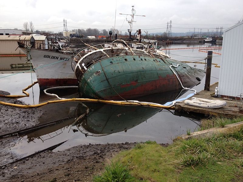
([field_image_credit])Derelict vessel, Helena Star

Pictured here in 2014, the old freighter Helena Star has been allowed to become derelict, leaking oil and pulling down its neighboring vessel, the Golden West. In 2014, the State of Washington announced it was pursuing criminal charges against the owner of the Helena Star, which sank in Tacoma's Hylebos Waterway, releasing oil and other pollutants.
([field_image_credit])Barge explosion

A fire burns at Delong Dock after an explosion on a fixed barge in Whittier, Alaska.
([field_image_credit])Golden Ray

A Coast Guard Air Station Savannah MH-65 Dolphin helicopter rests on the side of the Golden Ray, a 656-foot vehicle carrier, to drop off supplies for Coast Guard crews and port partners who attempt to locate and rescue the remaining four crew members aboard the Golden Ray, Sept. 9, 2019, in St. Simons Sound, near Brunswick, Georgia.
([field_image_credit])Vessel grounding in Missouri

Vessel grounding in Missouri
([field_image_credit])Tank farm fire in Houston
 Deer Park facility near Houston. More than 1,100 federal, state, and local first responders, agencies, and environmental cleanup contractors participated on-scene assessing, booming, and removing products from affected areas.")
Tank farm fire in Houston
([field_image_credit])Diesel spill in Kodiak, Alaska

Diesel spill in Kodiak, Alaska
([field_image_credit])Grounded barge on Harbor Island, Seattle

Grounded barge on Harbor Island, Seattle
([field_image_credit])Burning commercial fishing vessel in Oregon - fuel removed

Burning commercial fishing vessel in Oregon - fuel removed
([field_image_credit])Burning commercial fishing vessel in Oregon

Burning commercial fishing vessel in Oregon
([field_image_credit])Grounded fishing vessel in Alaska

Grounded fishing vessel in Alaska
([field_image_credit])Train derailment and sulfuric acid release

Train derailment and sulfuric acid release
([field_image_credit])Grounded fishing vessel in Alaska

Grounded fishing vessel in Alaska
([field_image_credit])Staten Island bunker fuel spill

Staten Island bunker fuel spill
([field_image_credit])Staten Island bunker fuel spill

Staten Island bunker fuel spill
([field_image_credit])Staten Island bunker fuel spill

Staten Island bunker fuel spill
([field_image_credit])Staten Island bunker fuel spill

Staten Island bunker fuel spill
([field_image_credit])Abandoned barge on Kodiak Island

Abandoned barge on Kodiak Island
([field_image_credit])Abandoned barge on Kodiak Island

Abandoned barge on Kodiak Island
([field_image_credit])Abandoned barge on Kodiak Island

Abandoned barge on Kodiak Island
([field_image_credit])Oil spill following ship fire

Oil spill following ship fire
([field_image_credit])Oil spill following a ship fire in Houston

Oil spill following a ship fire in Houston
([field_image_credit])Houston chemical fire
 Deer Park facility near Houston.")
Houston chemical fire
([field_image_credit])Houston chemical fire - sampling

Houston chemical fire - sampling
([field_image_credit])Selendang Ayu oil spill site

Selendang Ayu oil spill site
([field_image_credit])Selendang Ayu oil spill

Selendang Ayu oil spill
([field_image_credit])Selendang Ayu oil spill

Boom used at the Selendang Ayu oil spill.
([field_image_credit])Vessel collision and spill in Houston Ship Channel

Salvage operations in the Houston Ship Channel on May 13, 2019. Barge MMI 3041 capsized while in transit with Barge Kirby 3001ST on May 10, 2019 after the tanker Genesis River collided in the Houston Ship Channel.
([field_image_credit])Vessel collision and spill in Houston Ship Channel

A vessel collision occurred near Houston when a 755-foot tanker, MV Genesis River, and the tug Voyager collided in the Houston Ship Channel. Crews begin cutting into outer hull of capsized barge, MMI 3041 on May 13, 2019 located in the Houston Ship Channel in preparation for offloading.
([field_image_credit])Vessel collision and spill in Houston Ship Channel

A vessel collision that occurred near Houston when a 755-foot tanker, MV Genesis River, and the tug Voyager collided in the Houston Ship Channel. Crews prepare for cold-tap drilling operations to offload product and enable removal of barge from the Houston Ship Channel, May 13, 2019. Barge MMI 3041 capsized while in transit with Barge Kirby 3001ST on May 10, 2019 after the tanker Genesis River collided in the Ship Channel.
([field_image_credit])Coimbra

Coast Guard crew members work alongside New York State Department of Environmental Conservation and Resolve Marine Group to help assess the condition of the Coimbra wreck on April 30, 2019. The Coimbra was a supply ship owned by Great Britain when the ship was sunk off the coast of Long Island, during World War II by a German U-boat.
([field_image_credit])Coimbra

Sheen from oil leaking from the Coimbra. The Coimbra was a supply ship owned by Great Britain when the ship was sunk off the coast of Long Island, during World War II by a German U-boat.
([field_image_credit])Coimbra

Coast Guard crew members work alongside New York State Department of Environmental Conservation and Resolve Marine Group to help assess the condition of the Coimbra wreck on April 30, 2019. The Coimbra was a supply ship owned by Great Britain when the ship was sunk off the coast of Long Island, during World War II by a German U-boat.
([field_image_credit])Cosco Busan

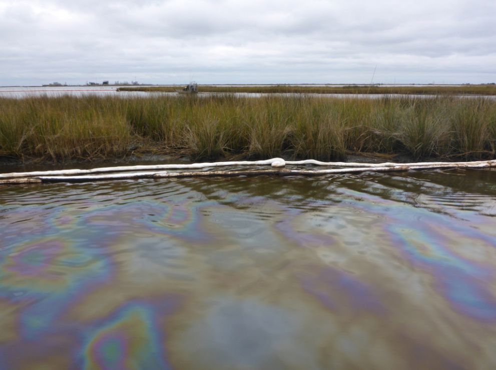
Lake Washington A10 well leak

View of oiled marsh and boom with oil sheen in foreground at the Lake Washington/Rattlesnake Bayou in Louisiana in December 2018.
([field_image_credit])Lake Washington A10 well leak - boom and response vessels

Overflight view of oil collection at the site of the Lake Washington A10 Well Leak, at the Lake Washington/Rattlesnake Bayou in Louisiana in December 2018.
([field_image_credit])Overflight view of the Lake Washington A10 well leak

View of oil trapped in a marsh area following the Lake Washington A10 Well Leak, at the Lake Washington/Rattlesnake Bayou in Louisiana in December 2018.
([field_image_credit])Lake Washington A10 well leak - oiled marsh

Oiled marsh following the Lake Washington A10 Well Leak, at the Lake Washington/Rattlesnake Bayou in Louisiana in December 2018.
([field_image_credit])Lake Washington A10 well leak - oiled grasses

Oiled grasses following the Lake Washington A10 Well Leak, at the Lake Washington/Rattlesnake Bayou in Louisiana in December 2018.
([field_image_credit])Deepwater Horizon - oil on water

Oil visible on the water’s surface in the Gulf of Mexico after the 2010 Deepwater Horizon oil spill.
([field_image_credit])Lave flow - Kilauea Volcano
 entered the ocean at Kamokuna, Hawaii County, NOAA collaborated with Hawaii Volcanoes National Park and the USGS Hawaiian Volcano Observatory in this effort.")
NOAA provided guidance for establishing a science-based safety zone where lava flowing from Kilauea Volcano (seen here in 2011) entered the ocean at Kamokuna, Hawaii County, NOAA collaborated with Hawaii Volcanoes National Park and the USGS Hawaiian Volcano Observatory in this effort.
([field_image_credit])Barge Apex collision

A view of the damaged barge Apex 3508, whose tug boat collided with another on Sept. 2, 2015, causing an oil spill on the Mississippi River near Columbus, Kentucky. The rest of the oil on board the barge was removed.
([field_image_credit])Sheen from Barge-E2MS-303 oil spill

Sheen visible at the water’s edge after Barge E2MS 303 collided with a towboat on February 22, 2014 and began leaking 750 barrels of Bakken crude oil into the lower Mississippi River.
([field_image_credit])Barge E2MS 303 collision

Barge E2MS 303 collided with a towboat on February 22, 2014 and began leaking 750 barrels of Bakken crude oil into the lower Mississippi River.
([field_image_credit])Argo Merchant sinking

As it sunk, the bow section drifted 400-500 yards to the southeast and was eventually sunk by the U.S. Coast Guard, while the stern section remained aground. Also, see full gallery of Argo Merchant photos: http://response.restoration.noaa.gov/argo-merchant-grounding-and-oil-spill.
([field_image_credit])Sinking of the Argo Merchant

When the Argo Merchant ran aground, it was carrying 7.7 million gallons of No. 6 fuel oil, a heavy refined oil. Its grounding was due to navigational errors. The vessel was found to be 24 miles off course, and carrying two unqualified crew as helmsman, a broken gyrocompass, outdated maps, and an inaccurate radio direction finder. Also, see full gallery of Argo Merchant photos: http://response.restoration.noaa.gov/argo-merchant-grounding-and-oil-spill.
([field_image_credit])Texas City Y oil spill

The Coast Guard, with state and local partners, is responds to an oil production platform fire in Bayou Sorrel, Louisiana, March 15, 2016. One of the tanks reportedly collapsed, releasing an unknown amount of crude oil into a canal.
([field_image_credit])Bayou Sorrel platform fire

The Coast Guard, with state and local partners, is responds to an oil production platform fire in Bayou Sorrel, Louisiana, March 15, 2016. One of the tanks reportedly collapsed, releasing an unknown amount of crude oil into a canal.
([field_image_credit])Shell--Green Canyon oil spill

Skimming operations being conducted on May 14, 2016, in response to an estimated 88,200 gallons of crude oil discharged from a segment of flow line at the Glider Field approximately 90 miles south of Timbalier Island, Louisiana.
([field_image_credit])Pipeline break at Refugio State beach

NOAA responded to the May 19, 2015 oil spill resulting from a pipeline break at Refugio State Beach, near Santa Barbara, California, which released an estimated 100,000 gallons of crude oil, with a reported 21,000 gallons reaching the ocean.
([field_image_credit])The drilling ship Kulluk aground near Kodiak Island, Alaska

A U.S. Coast Guard aerial survey reveals the rugged, remote landscape and the conical drilling unit Kulluk, grounded 40 miles southwest of Kodiak City, Alaska.
([field_image_credit])Vinyl Chloride Spill After Train Derailment
")
Seven train cars derailed near Paulsboro, N.J., when the bridge over Mantua Creek collapsed on November 30, 2012. Four tank cars containing vinyl chloride were dumped into the creek. ([field_image_credit])
R/R Cougar Ace

The "Cougar Ace", a 654-foot container ship transporting over 4,800 automobiles from Japan to Vancouver, British Columbia, Canada, began to take on water for an unknown reason late on July 26, 2006, about 245 nautical miles southwest of Atka, Alaska, and started to list to its port side. ([field_image_credit])
M/V Selendang Ayu

During early December of 2004, a huge storm drove the floundering M/V Selendang Ayu onto the rocky shoals on the west side of Unalaska Island in the Aleutian Islands, Alaska. Here, the vessel broke in two, releasing more than 75 percent (337,000 gallons) of its total petroleum fuel load of IFO-380 and marine diesel. Nearly all the oil was driven onto the mostly rocky shorelines of Makushin and Skan Bays.
([field_image_credit])Lake Perot Well Blowout

On January 21, 2007, a well head blowout occurred in Lake Perot, La.
([field_image_credit])M/V New Carissa

On February 4, 1999, the M/V New Carissa, a 639-foot bulk freight ship of Panamanian registry, went hard aground in heavy seas about 150 yards off a stretch of remote, undeveloped sandy beach three miles north of Coos Bay, Ore. The ship was intentionally ignited to burn the fuel oil and later broke in two.
([field_image_credit])Barge Millicoma

On March 21, 2005, Barge Millicoma ran aground near the mouth of the Columbia River off the coast of Washington state. The 350-foot barge broke loose from a tugboat towline in bad weather on the Columbia River bar. After two days, the ship was refloated and transported to Astoria, Ore., without incident.
([field_image_credit])M/V Kuroshima

On November 26, 1997, M/V Kuroshima, a 370-foot freighter, ran aground in Summer Bay, Alaska, after dragging anchor during a heavy storm near Dutch Harbor, Alaska.
([field_image_credit])M/V Kent Reliant

On September 18, 2003, M/V Kent Reliant grounded at the entrance to San Juan Harbor, Puerto Rico.
([field_image_credit])Hurricane Katrina

A boat, displaced and damaged in the aftermath of Hurricane Katrina, in late August/early September of 2005 in the U.S Gulf of Mexico region.
([field_image_credit])M/T Igloo Moon

The M/T Igloo Moon, a chemical tanker carrying a full cargo (6,589 metric tons) of butadiene to Houston, Texas, ran aground November 6, 1996, on a sand bottom, in 25 feet of water, within the Biscayne National Park boundary, in Florida. The vessel was also carrying 57,000 gallons of IFO 380, a heavy fuel oil similar to number 6; 30,000 gallons of marine diesel; and 6,000 gallons of lube oil.
([field_image_credit])Exxon Valdez Oil Spill

On March 24, 1989, the tanker Exxon Valdez ran aground on Bligh Reef in Prince William Sound, Alaska. Within six hours of the grounding, the Exxon Valdez spilled approximately 10.9 million gallons (259,500 barrels) of its 53 million gallon cargo of Prudhoe Bay crude oil. The oil would eventually impact more than 1,100 miles of non-continuous coastline in Alaska, making the Exxon Valdez the largest oil spill in U.S. waters at the time.
([field_image_credit])Deepwater Horizon Oil Spill

The Deepwater Horizon oil spill began in the Gulf of Mexico on April 20, 2010, when the BP deep ocean well Macondo blew out. The blow-out resulted in an explosion aboard the drilling rig Deepwater Horizon, killing 11 rig workers. The rig caught fire and sank two days later. As a result, approximately 3.19 million barrels (nearly 134 million gallons) of crude oil gushed from the seafloor for nearly three months. This incident became the largest oil spill in U.S. waters. Find the latest NOAA information related to this oil spill.
([field_image_credit])Barge DM 932

On July 23, 2008, the T/V Tintomara collided with the tug/barge (M/V Mel Oliver and DM932) near downtown New Orleans, La. The barge was ripped in half and spilled 6,738 barrels (283,000 gallons) of fuel, closing the Mississippi River to shipping for six days.
([field_image_credit])M/V Cosco Busan

The container ship M/V Cosco Busan struck the Bay Bridge in San Francisco Bay, Calif., on November 7, 2008. An approximate 100-foot gash in the hull of the vessel resulted, and 1,380 barrels (58,000 gallons) of fuel oil were released into the water.
([field_image_credit])M/V Cape Flattery

On February 2, 2005, M/V Cape Flattery, 550-foot cement carrier grounded at the entrance of Barber's Point, Hawaii, resulting in injury to coral.
([field_image_credit])Bouchard Barge No. 120

On April 27, 2003, Bouchard Barge No. 120 grounded at the entrance to Buzzard Bay in southern Massachusetts. The barge discharged approximately 2,333 barrels (98,000 gallons) of heavy number 6 fuel.
([field_image_credit])M/T Athos I

On November 26, 2004, the M/T Athos I, a 750-foot tanker, hit obstructions in the Delaware River near Philadelphia, Pa. The tanker, registered in Cyprus, was carrying 325,000 barrels (13.6 million gallons) of heavy crude oil from Venezuela.
([field_image_credit])Adak Oil Spill

On January 11, 2010, approximately 3,200 barrels (134,400 gallons) of diesel were released into a coastal stream from an underground tank operated by Adak Petroleum on Adak Island, Alaska.
([field_image_credit])Where the Cosco Busan came into contact with the San Francisco Bay Bridge.
