One Step Toward Reducing Chemical Disasters: Sharing with Communities Where Those Chemicals Are Located

APRIL 27, 2015 -- The year 2013 saw two major chemical disasters in the United States, which tragically killed 17 people and injured hundreds more.
As a result, President Obama signed Executive Order 13650 (EO 13650) August 1, 2013, followed by a report the next year to improve the safety and security of chemical facilities and to reduce the risks of hazardous chemicals to workers and communities.
As part of this directive, six federal agencies and departments, including the U.S. Environmental Protection Agency (EPA), formed a work group to investigate how to better help local communities plan for and respond to emergencies involving hazardous substances.
Out of these work group discussions came one area needing improvement which might sound surprising to the average person: data sharing.
Specifically, the work group highlighted the need to improve data sharing among the various federal programs that regulate hazardous substances and the state and local communities where those chemicals are produced, stored, and transported.
EPA works with NOAA on the chemical spill planning and response software suite known as CAMEO. These software programs offer communities critical tools for organizing and sharing precisely this type of chemical data.

Lots of Chemicals, Lots of Data
Many parts of the federal government, including several of the agencies involved in the work group, regulate hazardous chemicals in a number of ways to keep our communities safe. That means collecting information from industry on the presence or usage of hazardous substances in communities across the nation. It also results in a lot of data reported on the hazardous materials manufactured, used, stored, and transported in the United States. Making sure these data are shared with the right people is a key goal for chemical safety.
However, federal agencies do not require industry to report all of this information in consistent formats across agencies. Furthermore, this reported information on hazardous chemicals is generally not available to local emergency planners and responders—the very people who would need quick access to that information during a disaster in their community.
Trying to access, collect, and share all of this information is a challenge for state and local emergency responders trying to prevent the type of chemical disasters that devastated West, Texas, and Geismar, Louisiana, in 2013. Fortunately, however, NOAA and EPA have a suite of software tools—known as CAMEO—that helps make this task a little easier.
One State's Approach to Better Data Sharing
As required by the Emergency Planning and Community Right-to-Know Act (EPCRA), which was passed to help communities plan for emergencies involving hazardous substances, each state, Local Emergency Planning Committee, and local fire department receives hazardous material information via hazardous chemical inventories, or "Tier 2" reports. This information represents one part of the picture for local communities, but as the federal work group pointed out, it is not enough.
Already familiar with the CAMEO software suite, Oklahoma’s state emergency planners decided to use this complementary set of programs to tackle the goal of better sharing chemical safety data, as outlined in Executive Order 13650.
Under EPCRA, each state is required to have a State Emergency Response Commission to oversee the law’s hazardous chemical emergency planning programs. In Oklahoma, the group is known as the Oklahoma Hazardous Materials Emergency Response Commission (OHMERC).
As their first step toward improving chemical data sharing with local planners, OHMERC set out to obtain hazardous material information from the EPA, Department of Homeland Security, and Bureau of Alcohol, Tobacco, Firearms, and Explosives. Then, they sought to make that information available to all Oklahoma Local Emergency Planning Committees (LEPC). Subsequently, these federal agencies began to contact other state representatives to explore avenues to share these data.
Each of the three federal agencies OHMERC contacted provided non-sensitive hazardous material program data—plus the state already had access to some of the information—but these data were in different file formats. Some were contained in spreadsheets, others as PDF files, and still others delivered in text documents. As a result, there was no consistent format for delivering the information to local emergency planners.
Going Local
Oklahoma Local Emergency Planning Committees already use the CAMEO suite of software to manage their Tier 2 (EPA hazardous chemical inventory) reports. As a result, OHMERC decided to use the database program CAMEOfm to deliver additional information from other federal hazardous material programs to these local committees.
For each Tier 2 report, CAMEOfm has an "ID and Regs" section, which typically contains standard identifying codes for each local facility dealing with chemicals. For the appropriate facilities, OHMERC added new designations to the ID fields for the additional regulatory data from the Department of Homeland Security, EPA, and Bureau of Alcohol, Tobacco, Firearms, and Explosives.
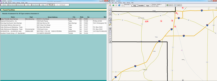
Now, local planners can search CAMEOfm to see which facilities in their jurisdiction are subject to several other hazardous material regulatory programs. If interested, local planners then can contact a facility, inquire why it is regulated by a particular program, gather more information, and plan directly with that facility.

Since all the CAMEOfm records are linked to the MARPLOT mapping program (also part of the CAMEO software suite), Local Emergency Planning Committees now have the information mapped as well. For example, a planner from Tulsa County can search CAMEOfm for locations with chemicals regulated under the Department of Homeland Security’s Chemical Facility Anti-Terrorism Standards program (CFATS) and the EPA's Risk Management Plan and Toxics Release Inventory programs. Next, the planner can display the results on a map using MARPLOT.
In addition, Oklahoma facilities regulated under EPA's Risk Management Plan program have been encouraged to include the non-sensitive parts of their plans in the "Site Plans" section of CAMEOfm. Many, though not all, of these sites did so, realizing this was an effective method to ensure the local first responders had access to that important information.
Getting Data in Ship Shape
Oklahoma's Local Emergency Planning Committees now have all of this chemical safety information in a consistent format, located in a familiar program where they easily can access it for planning and response efforts.
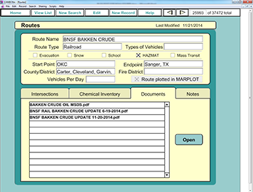
Another timely example of how Oklahoma is using this CAMEOfm and MARPLOT combination is for managing information on rail shipments of Bakken crude oil through the state. Bakken oil is a highly flammable type of oil typically shipped by train from the Bakken region of North Dakota and Montana and has been involved in a number of high-profile explosions and fires after train cars carrying it have derailed.
OHMERC entered this shipment information, provided by the railroads, into CAMEOfm, where it becomes linked to the appropriate railroad map objects in MARPLOT. OHMERC then sends this material in the CAMEOfm and MARPLOT format to the relevant Local Emergency Planning Committees.
Using these programs to better share data is a step that any emergency planner or responder can take. You can find more information about the CAMEO software suite at response.restoration.noaa.gov/cameo.
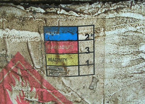
This is a guest post by Oklahoma emergency planner Tom Bergman. He is the author of the CAMEO Companion and host of the www.cameotraining.org website. Tom is the EPCRA (Emergency Planning and Community Right-to-Know Act) Tier 2 Program Manager for the State of Oklahoma and has been a CAMEO trainer for many years. He has conducted CAMEO training courses in Lithuania, Poland, England, Morocco, and 45 U.S. states. Photo of chemical drum used via Creative Commons: killbox, Attribution 2.0 Generic License
 An official website of the United States government.