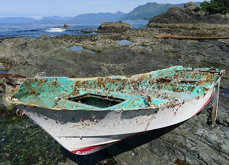
Small Japanese Boat Found near Vancouver Island, Canada, Even as Summer Currents Hold Marine Debris at Bay for now
AUGUST 24, 2012 -- On remote Spring Island, northwest of Vancouver Island, Canada, a small boat inscribed with Japanese characters washed up with the tide this summer. A Canadian provincial official has confirmed this boat was lost during the 2011 Japan tsunami. Emergency Management British Columbia matched the serial number on the boat's hull with one on the Japanese consulate's list of vessels lost due to the tsunami. Eric Gorbman, who owns a nearby resort, and Kevin Head found and reported the boat on August 9, 2012.
A Summer Decrease in Debris
While this brings the total number of confirmed tsunami debris sightings to 11, summer weather patterns have created a lull in debris turning up on nearby Washington's coast. This has the state Department of Ecology taking back some of the additional trash receptacles they provided near public access points earlier this summer. Recent decreases in reported marine debris in these areas, along with reports of someone using them to dump household waste, led to the removal.
"We want to ensure we are stretching our dollars as far as we can," said Peter Lyon, a Washington Department of Ecology regional manager. "In June, when the boxes were placed along beaches, a southwest wind pattern directed more debris ashore in those areas than we are seeing now. When weather patterns shift again in the fall, we are likely to see higher amounts of debris again. So we want to conserve our resources in case that happens."
The Washington Department of Ecology states that the trash bins can be easily and quickly redeployed within about 24 hours to accommodate possible increases in marine debris in the future. The funding to stock the bins and litter bags came from Department of Ecology’s litter account, setting aside $100,000 to deal with marine debris. These supplies help support community and volunteer efforts to collect and dispose of debris on Washington beaches.
Where Is the Debris Now?
NOAA's Office of Response and Restoration has oceanographers Glen Watabayashi and Amy MacFadyen using our GNOME model to give us an understanding of where debris from the tsunami may be located today. GNOME is a software modeling tool used to predict the possible route pollutants might follow in a body of water, and we use it most frequently during an oil spill.
Our oceanographers are incorporating into this model how the winds and ocean currents since the tsunami may have moved items through the Pacific Ocean. However, rather than forecasting when debris will reach U.S. shores in the future, this model uses data from past winds and currents to show possible patterns of where debris may be concentrated right now.
"For me the story is not what's been found but what hasn't been found," said NOAA oceanographer Glen Watabayashi. "With all the summer vessel traffic along the West Coast and out in the North Pacific, there have been no reports of any large concentrations of debris."
Learn more at http://marinedebris.noaa.gov/tsunamidebris/.
 An official website of the United States government.
