 An official website of the United States government.
 Map of the Month: Natural Resource Damage Assessment Settlements: 1990-2019
The Environmental Response Management Application (ERMA®) is NOAA’s online mapping tool that integrates both static and real-time data, enabling users to quickly and securely access, analyze, and display spatial data.
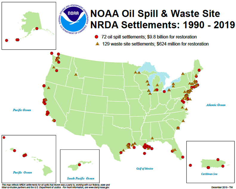
This map shows the locations of over 200 oil spill and hazardous waste sites where NOAA and partners from state, tribal, and federal agencies and industry have recovered over $10.4 billion to restore a wide variety of critical public habitats and resources nationwide.
Natural Resource Damage Assessment (NRDA) is the process that NOAA and other trustees use to study the effects of these pollution incidents on fish, wildlife, surrounding habitats, and public use of those resources. Scientists work together to identify the extent of natural resource damage and specify the type and amount of restoration required.
Since 1990, NOAA’s Damage Assessment, Remediation, and Restoration Program (DARRP) has been integral to the NRDA process through its work assessing, restoring, and protecting polluted coastal environments.
Our restoration projects benefit coastal communities by enhancing fisheries and wildlife, restoring protected species (e.g., sea turtles, dolphins) and sensitive habitats (wetlands, corals). These projects also provide economic benefits from recreation (fishing, boating, swimming), tourism, green jobs, coastal resiliency, property values, and quality of life.
For more information about the NRDA process, visit the DARRP website. To access an interactive version of this map, click here and explore individual projects.
January’s Map of the Month comes from Tom Brosnan in Washington D.C. and Terrance Wang in Seattle.