 An official website of the United States government.
 Map of the Month: Rapid Response to Pollution Threats Following Hurricane Ida
The Environmental Response Management Application (ERMA®) is NOAA’s online mapping tool that integrates both static and real-time data, enabling users to quickly and securely access, analyze, and display spatial data.
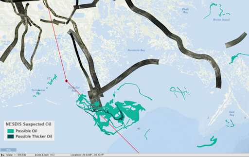
This map of the Port Fouchon area is displaying the aerial overflight imagery collected by the National Geodetic Survey (NGS) as well as possible oil observed in satellite imagery obtained by the National Environmental Satellite, Data, and Information Service. The red track is the best track line for Hurricane Ida provided by the National Hurricane Center (NHC).
Last month, on the 16th anniversary of the landfall of Hurricane Katrina, Hurricane Ida made landfall near Port Fourchon, Louisiana as a Category 4 hurricane. In the aftermath of Ida’s arrival, OR&R and partner agencies have been using ERMA (Environmental Response Management Application) as a common operating picture in the response and recovery operation.
ERMA has been used to provide scientific support and data to U.S. Coast Guard response efforts, including the display of aerial imagery collected by NGS and potential locations of oil spills from NOAA’s National Environmental Satellite, Data, and Information Service (NESDIS), marine debris targets, and navigational hazards.
To learn more, please visit the live map on Gulf of Mexico ERMA.
This "Map of the Month" is brought to you by George Marino from the OR&R Disaster Preparedness Program and Assessment and Restoration Division.