Map of the Month: Sea Turtle Nesting Habitat Density
The Environmental Response Management Application (ERMA®) is NOAA’s online mapping tool that integrates both static and real-time data, enabling users to quickly and securely access, analyze, and display spatial data. The "Map of the Month" series highlights unique maps from throughout ERMA's use and history.
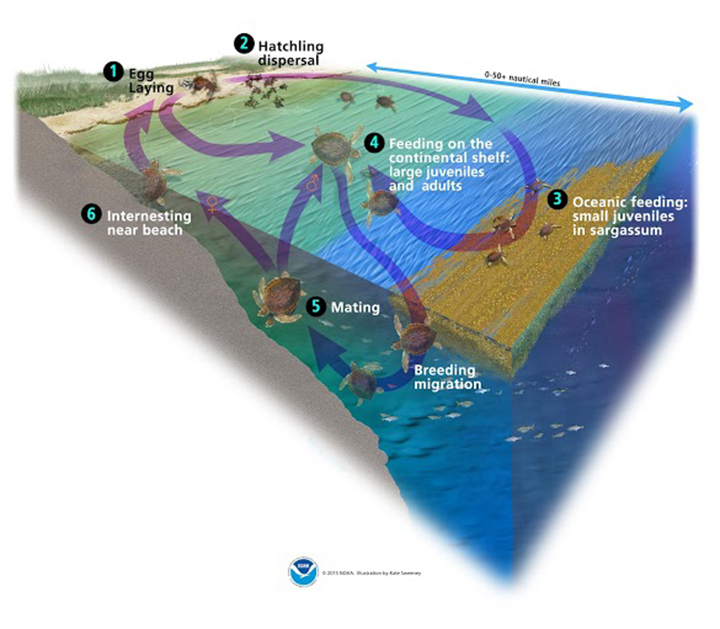
June 16, 2021 — Today we’re Shell-ebrating National Sea Turtle Day! Did you know that sea turtles in the Gulf of Mexico are born on beaches and spend their early years floating among matts of sargassum seaweed? Since oil spills can impact both of these habitats, it’s important for NOAA scientists to understand sea turtle life cycles to understand the impacts of pollution and restore the environment afterwards.
This map shows sea turtle nesting habitat density (how many sea turtles are laying eggs in that area) in yellow, orange, and red. The blue shading shows areas where sensitive sea turtles could be found in the event of an oil spill. Sargassum habitat, the floating seaweed where young turtles drift with ocean currents, is shown in green shading.
All of this information is available in ERMA for NOAA experts to access quickly to protect sea turtles in the event of an oil spill emergency. Check out our sea turtle graphic to learn about their life cycle, and our interactive ERMA Map to learn more!
This Map of the Month is brought to you by Adam Rotert and Megan Ewald from the Assessment and Restoration Division.
more images

 An official website of the United States government.

