Mapping Tool ERMA Gets a New Look, Updates to Improve Usability
SEPT. 19, 2022 — On Sept. 1, 2022, the Office of Response and Restoration’s Environmental Response Management Application (ERMA) team released a new version of the application. The overhauled look and layout focuses on providing a streamlined interface to visualize and explore spatial data.
While the most notable change is the user interface, there are multiple other enhancements and security features included in the update. This new layout leverages the latest technology along with a responsive design that supports mobile and tablet use. On a desktop, the tools menu is located on the right side of the application but moves to the bottom on smaller screens.
ERMA is the common operational picture for NOAA and the U.S. Coast Guard during environmental responses like oil spills. It provides centralized access for environmental resource managers with the data necessary to make informed decisions during a response, damage assessment and recovery/ restoration. NOAA used input from our users to inform the new design of the application.
What’s New:
For years, the application relied upon its original layout and interface to provide users with tools to explore spatial data. However, this new version of the application keeps all the same functionality but streamlines and consolidates workflows. NOAA has replaced the numerous tabs with a menu bar that can be collapsed to show more of the map. Additionally, application headers and banners have been shortened to keep the focus on the map data.
Search: Consolidated every type of search a user can perform is now contained within the main search bar. Before, users would have to search for vessels in a different part of the tools.
Query: The workflow has been streamlined allowing a user to select one of the three query types in a dropdown.
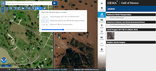
Swipe Map Tool: A new map tool is located along with the other map tools and can be enabled using the double arrow icon. When it is enabled, a vertical line appears that can be moved left or right. The settings allow a user to select the data can be turned off or on each side of the line. The swipe tool was funded by the Disaster Preparedness Program’s Lagniappe Awards, which aimed at providing functionality that helps users compare pre and post storm imagery. Shown below is pre- and post-storm Hurricane Harvey imagery.
more images
more images