 An official website of the United States government.
 NOAA Response Teams Provide Scientific Support to Well Rupture off Louisiana Coast

An overflight displays the affected area of marsh environment near Garden Island Bay, Louisiana on April 27, 2025. Image credit: NOAA.
NOAA’s Office of Response and Restoration (OR&R) is aiding in the response to an oil and natural gas release following a well rupture in a marsh environment in Plaquemines Parish, southeast of New Orleans, Louisiana.
JUNE 11, 2025 — On Saturday, April 26, 2025, a well was reported to be discharging oil and natural gas into marsh and surrounding waters near Garden Island Bay, Louisiana. The leak originated from Spectrum OpCo, LLC, Garden Island Bay Production Facility’s company well (Well #59). A Unified Command, composed of the U.S. Coast Guard and the Louisiana Oil Spill Coordinator's Office, was established to direct the spill response efforts. The wellhead was secured on Sunday, May 4, 2025, ending the discharge of oil and natural gas. The well is located in the Pass-A-Loutre Wildlife Management Area, an environmentally sensitive area.
NOAA began providing on-site and remote scientific support at the request of the U.S. Coast Guard on Monday, April 28, 2025. OR&R is delivering cutting-edge, real-time visual surveillance to support coordinated response efforts across the Unified Command. Oil recovery and mitigation efforts are ongoing. NOAA leads scientific support to a multi-agency workgroup tasked with evaluating cleanup strategies.

NOAA Scientific Support Coordinator observes the extent and condition of oil during an overflight of the Well #59 rupture, April 28, 2025. Image credit: Forefront and NOAA.
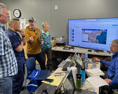
Members of the OR&R response team brief USCG Rear Admiral David C. Barata Eighth District Commander on NOAA’s incident support from the Incident Command Post on May 3, 2025. Image credit: NOAA.
Mitigation and Recovery of Discharged Oil
OR&R provided on-site and remote scientific support, including oil spill trajectory analyses and forecasts, identifying potential ecological resources at risk, conducting overflights of the spill, capturing satellite and high-resolution aerial imagery, and integrating aerial and on-water observations into spatial maps for use by responders.
Containment and recovery operations included flushing methods and on-water skimming cleanup techniques to collect recoverable oil out of vegetation and the area around the secured wellhead to transfer it to storage tanks and facilities. While oiled areas were evaluated for in-situ burning — the controlled burning of discharged oil — burning was not used for this response. Instead, teams employed selective cutting of marsh vegetation in areas of heaviest impact, and deployed Pom Pom sorbents, which absorb and capture oil through synthetic filaments, to recover standing emulsified oil. Containment booms to capture oil were adjusted based on shifting winds throughout the response.
OR&R continues to support aerial surveys of impacted shorelines to assess the response team’s progress towards meeting shoreline cleanup endpoints.
OR&R is also providing situational awareness and a common operating picture to the Unified Command via the Environmental Response Management Application (ERMA®). ERMA is an online mapping tool that integrates overflight and unmanned aircraft system (UAS) high-resolution imagery and photographs collected by NOAA with operational data, including containment and recovery operations, and air monitoring data. The integration of scientific expertise, spatial data tools, and data management capabilities are essential to operational effectiveness; and enables timely, strategic decision-making for cleanup and mitigation efforts.

An ERMA dashboard displaying aerial assessment data of Well #59 incident spill area. Left: Imagery of the well source collected by remotely controlled uncrewed aerial systems, commonly called drones, and processed into high resolution mosaics. The accompanying legend explains the meaning of the symbols used in the map, including the well source, dark oil, etc. Right: Overflight image captured on May 2, 2025.
Assessing Damages to Natural Resources
NOAA scientists and partners from natural resource trustee agencies collected data on-site from May 13-16, 2025 to support the Natural Resource Damage Assessment for the oil spill.
The field team, consisting of staff from NOAA, Louisiana Department of Environmental Quality, and Louisiana Coastal Protection and Restoration Authority, collected water column and surface sediment samples throughout the impacted area and in an adjacent reference site. Passive samplers, consisting of silicone bands that absorb oil compounds from the water column, were used over the three-day deployment to collect the water column samples. Samples will be analyzed for oil compounds at the NOAA National Centers for Coastal Ocean Science Hollings Marine Lab. The field team also observed shoreline oiling and recorded the species, number, and degree of external oiling of birds within and between sampling locations. Together, these data will provide information on the habitats, plants, and animals exposed, and the level of exposure to oil, in the impacted area.
The trustees will combine these field data with response observations (e.g., drone and satellite imagery, wildlife reports) to quantify the extent and severity of natural resource injuries resulting from the oil spill, which will inform the type and amount of restoration needed to compensate the public.
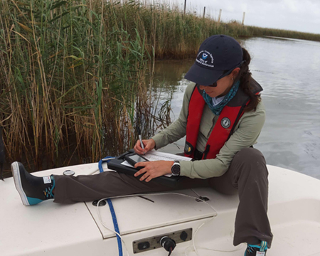
OR&R scientist documents field sample collection along an oil-stained marsh edge. Image credit: NOAA.
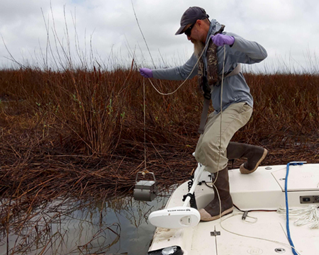
OR&R scientist collects surface sediments in a heavily impacted marsh area near the ruptured wellhead. Image credit: NOAA.
Mobilized Experts and Resources Across NOAA
The National Weather Service deployed an on-site meteorologist to support response and restoration efforts, providing real-time weather updates to guide planning and adjustments to on-water and flight operations. NOAA’s Satellite Analysis Branch is providing 24/7 support to OR&R, the U.S. Coast Guard, and offices within the Department of Homeland Security. This includes distribution of near-real time Marine Pollution Surveillance Reports that identify potential oil from satellite imagery and tailored satellite products upon request. NOAA Fisheries is engaging with state and federal agencies, local stranding network partners, and contractors employed by Spectrum OpCo, to assess potential needs for intervention and response to trust resources, including sea turtles and marine mammals; and providing best management practices to avoid impacts to protected resources from cleanup operations.
For operational questions related to the Well #59 incident, visit the latest U.S. Coast Guard press release.
more images


 and LDEQ scientist (left) prepare to deploy a silicone passive sampling band adjacent to oiled marsh edge habitat. Image credit: NOAA.")

more images