OR&R Provides Scientific Support to U.S. Coast Guard for Oil Spill off Louisiana Coast
DEC. 4, 2023 — On November 16, 2023, OR&R and U.S. Coast Guard (USCG) response teams activated as reports came in regarding a leak in a pipeline in the Gulf of Mexico, off the coast of Plaquemines Parish, Louisiana. The source of the leak was reported to be at least 19 miles offshore of the Mississippi River Delta, near the pipeline system of Main Pass Oil Gathering, LLC (MPOG).
In response to the crude oil release, known as the MPOG 11015 incident, a Unified Command was established by the USCG, the responding party MPOG, and the Louisiana Oil Spill Coordinator's Office, in coordination with NOAA, Louisiana Department of Environmental Quality, Forefront Emergency Management and other federal, state and local agencies to develop and execute a response strategy. For decades, the USCG and NOAA have played a joint role in ensuring vital operational support and response capabilities for oil and chemical spills. After the reports were received, OR&R began deploying to provide response support on-scene to the incident management team, the Federal On-scene Coordinator (U.S. Coast Guard), and Unified Command based in Belle Chasse, Louisiana.
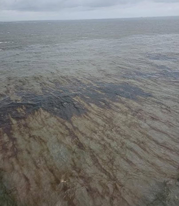
On-scene, response teams identified the leak as crude oil, however, the exact location, time of the release, and the amount of oil is still being evaluated. Initial engineering calculations indicate the potential volume of oil is 1.1 million gallons (about one tenth the size of the Exxon Valdez spill). On November 17, USCG aircraft and NOAA satellite imagery observed a slick of over 40 miles in length, heading southwest from the leak location; however, overflights in the following days observed intermittent surface sheens.
Since November 21, no new or continuous oil discharge has been reported. Remotely Operated Vehicle (ROV) surveys and assessments are ongoing by the pipeline owners, USCG, and Bureau of Safety and Environmental Enforcement (BSEE) to determine the source location of the spill. ROVs will continue to survey the pipeline, as weather conditions permit.
OR&R mobilized to provide scientific support
OR&R has provided scientific support, including spill trajectory and fate modeling, information on resources at risk, and coordination of NOAA capabilities with the spill response. OR&R obtained and analyzed samples from the pipeline to characterize the oil’s physical and chemical properties, enabling the response team to better predict how the oil will move and its impacts on the environment. A NOAA Scientific Support Coordinator reported to the incident command post on November 16, and additional NOAA OR&R staff continued to arrive in the following days. The staff included a science team led by OR&R’s chief scientist to conduct small science experimentation, drifter deployment, and data collection—separate from the response—to support future oil spill response and damage assessment technologies (funded as a research effort).
In the week following the arrival of responders on-scene, overflights observed intermittent surface sheens. Oil features such as golf ball-size tar balls and larger emulsified oil patties have been observed by vessels on-scene. Surface monitoring is ongoing with additional overflights and shoreline surveys in the Mississippi Delta. Initially, weather conditions during the week of November 17 impeded full access to some remote areas for surveying.
On November 19, OR&R began the initial phase of a Natural Resource Damage Assessment (NRDA), with a lead coordinator deploying on-scene for vessel deployment and assessments. OR&R engaged with trustees, including the Louisiana Oil Spill Coordinator's Office and U.S. Fish and Wildlife Service, on natural resource injury assessment and will continue to work together as they move through the NRDA process.
Experts across NOAA contribute to spill response
Beyond OR&R’s specific technical and scientific support, NOAA also engaged in multiple ways to the incident. At the time of the incident, NOAA Ship Oregon II was conducting a groundfish survey in the surrounding area and played a key role in the initial observation of the slick, and reported observations to OR&R to assist with assessments and trajectory forecasting. NOAA Fisheries supported the response effort by engaging with the Incident Command Wildlife Branch to identify oil-impacted sea turtles and marine mammals and possible tactics to help those animals, including rehabilitation. NOAA Fisheries also provided best management practices to mitigate the impact of cleanup activities on marine habitats and species, and provided technical support related to endangered and threatened species in the area including the Rice’s whale and sea turtles, for both response and Natural Resource Damage Assessment. In addition, NOAA’s National Environmental Satellite, Data, and Information Service produced Marine Pollution Surveillance Reports, using satellite imagery, to identify oil presence. Weather forecasts produced by NOAA’s National Weather Service supported the response and associated scientific support products.
Next steps for response effort
On November 22, the on-scene NOAA staff officially demobilized as the response became focused on locating the spill source and size. In the following weeks, NOAA will continue to support the USCG remotely in its response efforts. The Natural Resource Damage Assessment process to support restoration of injured natural resources will also continue, with support from OR&R’s Assessment and Restoration Division.
New information on the incident will be provided by the Unified Command. Learn more about NOAA’s role supporting oil spill response efforts and injured natural resource restoration.
 An official website of the United States government.
