 An official website of the United States government.
 Home | OR&R Research Projects | Detecting and Characterizing Oil Slick Thickness Using Remote Sensing
Detecting and Characterizing Oil Slick Thickness Using Remote Sensing
NOAA scientists teamed up with interdisciplinary partners to see if satellite technology, which was pioneered during Deepwater Horizon to detect and measure oil spill footprints on the surface of the ocean, is being advanced to estimate oil slick thickness.
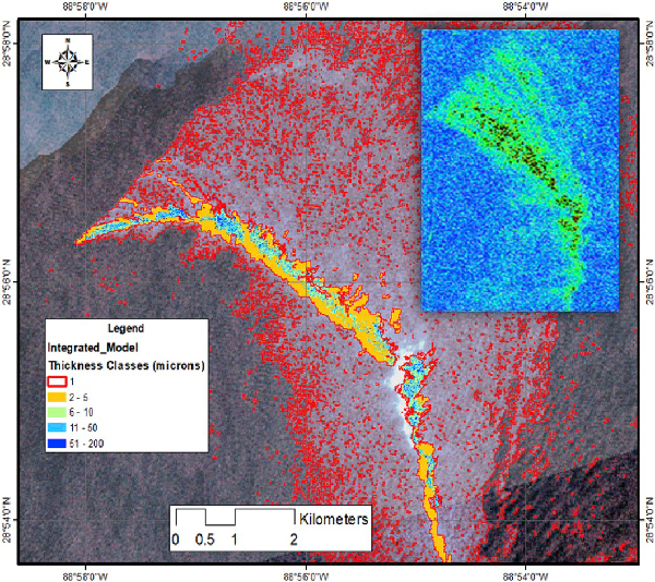
Satellite Synthetic Aperture Radar (SAR) can measure the roughness of the ocean’s surface. Oil dampens tiny, wind-driven waves and bounces less energy back to the satellite, making oil slicks appear darker than their surroundings. The team of scientists wanted to see if they could also detect the difference between thick crude oil, oil-water mixtures called emulsions, and thin sheens using SAR.
Researchers used two testing sites, a massive outdoor test tank, and an open water site. In both cases researchers on the ground measured the thickness of the oil slicks—using dip plates and other methods to directly measure the oil thickness—while multiple remote sensors zoomed in from above.
They found that SAR measurements were capable of differentiating oil from oil mixed with water, both at the testing tank and the open water siteo, and delivering that information in near-real-time.
Why is this Research Important?
It is not always practical, safe, or affordable to conduct measurements on-site, and satellites can see things that the human eye can’t. Satellite remote sensing can collect information over a greater area, and deliver information in near real-time.
This technology could help oil spill responders detect thick “actionable” oil that can be cleaned up, or contained, faster than ever before.
To Learn More Visit:
Bureau of Safety and Environmental Enforcement (BSEE) Report: Deepwater Horizon Lessons Learned, Methodology and Operational Tools to Assess Future Oil Spills.
Remote Sensing of Environment Article: Classification of oil spill by thicknesses using multiple remote sensors.
NOAA Office of Response and Restoration Blog: How Thick is the Oil Slick?