 An official website of the United States government.
 What’s New in ERMA®: Service Feeds, Dashboard Enhancements, and More
MAY 5, 2025 — NOAA’s Office of Response and Restoration recently released the latest version of the Environmental Response Management Application (ERMA®). ERMA is a web-based mapping application used by environmental responders and natural resource decision-makers. During environmental disaster response and cleanup, it serves as the common operating picture for NOAA, the U.S. Coast Guard, and other state and federal agencies by providing a consolidated view of static and real-time information that enhances situational awareness, improves interagency collaboration, and streamlines decision-making. Below are the key enhancements in the latest release, ERMA 5.5, including a host of new features and optimizations.

Expanded Capabilities for Data Display, Analysis, and Processing
With the latest release, ERMA has transitioned to a new data loader that significantly enhances the display of external data streams, such as live weather. Previously, data from external sources offered limited options for editing and querying. The new data uploader creates a table "copy" of the feed, which supports a wider variety of data types. This allows us to customize map symbology, calculate statistics for display in dashboards, and query data for these external data streams. Even though a copy is being used, ERMA still automatically updates the data and refreshes the table copy.
Enhanced Map Card Filtering In Dashboards
Within the Dashboard map card, ERMA users can now filter cards based on a custom-drawn polygon. This feature enables users to draw and select an area on the map to improve the relevance of the metrics and data showcased in the dashboard. This selection allows the dashboard to filter and display data within the defined region, making it easier for users to analyze information that is most pertinent to their needs.
For example, in the screenshot below of an ERMA dashboard displaying active cases from NOAA’s Damage Assessment, Remediation, and Restoration Program, users can draw an area of interest by selecting “Add” at the top of the map card.
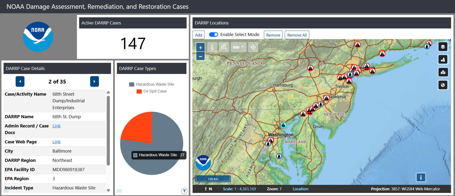

With the area of interest now drawn, use select mode to modify or highlight specific drawings and remove them, as needed. Cards on the left will change only to reflect the sites chosen in the area of interest. This is also reflected at the bottom left of the card with the rectangular icon.
The active DARRP cases card does not have this icon, so nothing has changed with the area of interest polygon filter added. This new feature ensures that your chosen area of interest is reflected across chosen dashboard cards, making analysis more intuitive and tailored to user needs.
Leveraging User Feedback for ERMA Improvement
As ERMA continues to evolve, enhancements introduced in this version highlight our commitment to improving user experience and data accessibility for environmental responders. New features streamline workflow and also equip users with more robust tools for analysis and decision-making during critical response efforts.
Users are encouraged to delve into the application, take full advantage of the latest updates, and provide suggestions about how the application could be improved or made more useful. Feedback is invaluable as we strive to refine ERMA further, and we look forward to sharing more exciting updates in the future.