After an Oil Spill, How—and Why—Do We Survey Affected Shorelines?
This is part of the National Ocean Service's efforts to celebrate our role in the surveys that inform our lives and protect our coasts.
MARCH 20, 2015 -- In March of 1989, oil spill responders in Valdez, Alaska, had a problem. They had a very large oil spill on their hands after the tanker Exxon Valdez had run aground on Bligh Reef in Prince William Sound. At the time, many aspects of the situation were unprecedented—including the amount of oil spilled and the level of response and cleanup required. Further complicating their efforts were the miles and miles of remote shoreline along Prince William Sound.
How could responders know which shorelines were hardest hit by the oil and where they should focus their cleanup efforts? Plus, with so many people involved in the response, what one person might consider "light oiling" on a particular beach, another might consider "heavy oiling." They needed a systematic way to document the oil spill's impacts on the extensive shorelines of the sound.
Out of these needs ultimately came the Shoreline Cleanup Assessment Technique, or SCAT. NOAA was a key player involved in developing this formal process for surveying coastal shorelines affected by oil spills. Today, we maintain the only SCAT program in the federal government although we have been working with the U.S. Environmental Protection Agency (EPA) to help develop similar methods for oil spills on inland lakes and rivers.
Survey Says
SCAT aims to describe both the oil and the environment along discrete stretches of shoreline potentially affected by an oil spill. Based on that information, responders then can determine the appropriate cleanup methods that will do the most good and the least harm for each section of shoreline.
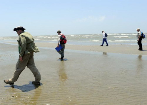
The teams of trained responders performing SCAT surveys normally are composed of representatives from the state and federal government and the organization responsible for the spill. They head out into the field, armed with SCAT’s clear methodology for categorizing the level and kind of oiling on the shoreline. This includes standardized definitions for describing how thick the oil is, its level of weathering (physical or chemical change), and the type of shoreline impacted, which may be as different as a rocky shoreline, a saltwater marsh, or flooded low-lying tundra.
After carefully documenting these data along all possibly affected portions of shoreline, the teams make their recommendations for cleanup methods. In the process, they have to take a number of other factors into account, such as whether threatened or endangered species are present or if the shoreline is in a high public access area.
It is actually very easy to do more damage than good when cleaning up oiled shorelines. The cleanup itself—with lots of people, heavy equipment, and activity—can be just as or even more harmful to the environment than spilled oil. For sensitive areas, such as a marsh, taking no cleanup action is often the best option for protecting the stability of the fragile shoreline, even if some oil remains.

Data, Data Everywhere

Having a common language for describing shoreline oiling is a critical piece of the conversation during a spill response. Without this standard protocol, spill responders would be reinventing the wheel for each spill. Along that same vein, responders at NOAA are working with the U.S. EPA and State of California to establish a common data standard for the mounds of data collected during these shoreline surveys.
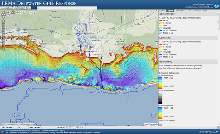
Managing all of that data and turning it into useful products for the response is a lot of work. During bigger spills, multiple data specialists work around the clock to process the data collected during SCAT surveys, perform quality assurance and control, and create informational products, such as maps showing where oil is located and its level of coverage on various types of shorelines.
Data management tools such as GPS trackers and georeferenced photographs help speed up that process, but the next step is moving from paper forms used by SCAT field teams to electronic tools that enable these teams to directly enter their data into the central database for that spill.
Our goal is to create a data framework that can be translated into any tool for any handheld electronic device. These guidelines would provide consistency across digital platforms, specifying exactly what data are being collected and in which structure and format. Furthermore, they would standardize which data are being shared into a spill's central database, whether they come from a state government agency or the company that caused the spill. This effort feeds into the larger picture for managing data during oil spills and allows everyone working on that spill to understand, access, and work with the data collected, for a long time after the spill.
Currently, we are drafting these data standards for SCAT surveys and incorporating feedback from NOAA, EPA, and California. In the next year or two, we hope to offer these standards as official NOAA guidelines for gathering digital data during oiled shoreline surveys.
To learn more about how teams perform SCAT surveys, check out NOAA's Shoreline Assessment Manual and Job Aid.
 An official website of the United States government.
