 An official website of the United States government.
 An Example Shoreline Ranking
 Shorelines on Environmental Sensitivity Index (ESI) maps are color-coded based on sensitivity to oil. Shorelines that are least susceptible to oil are ranked as 1 and are color-coded dark purple on ESI maps. Shorelines that are most likely to be damaged by oil are ranked as 10 and appear in red.
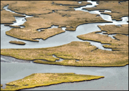
Below is an example of the physical description and predicted oil behavior for a shoreline with an ESI rank of 10A. Shoreline types meeting these definitions include salt- and brackish-water marshes, such as the section of marsh shown at right (from the Alabama ESI atlas).
Shorelines that fall under the ESI 10 ranks (10A-E) are the most sensitive habitats because of their high biological use and value, difficulty of cleanup, and potential for long-term impacts to many organisms.
Description of a 10A Shoreline
- Intertidal wetlands containing emergent, herbaceous vegetation.
- Width of the marsh can vary widely, from a narrow fringe to extensive areas.
- Sediments are composed of organic muds except on the margins of islands where sand is abundant.
- Exposed areas are located along bays with wide fetches and along heavily trafficked waterways.
- Sheltered areas are not exposed to significant wave or boat wake activity.
- Resident flora and fauna are abundant with numerous species with high utilization by birds, fish, and shellfish.
- Very common behind barrier islands and along the outer coast.
Predicted Oil Behavior for 10A Shorelines
- Oil adheres readily to intertidal vegetation.
- The band of coating will vary widely, depending upon the water level at the time oil slicks are in the vegetation; there may be multiple bands.
- Large slicks will persist through multiple tidal cycles and coat the entire stem from the high-tide line to the base.
- If the vegetation is thick, heavy oil coating will be restricted to the outer fringe, although lighter oils can penetrate deeper, to the limit of tidal influence.
- Medium to heavy oils do not readily adhere to or penetrate the fine sediments, but can pool on the surface or in burrows.
- Light oils can penetrate the top few centimeters of sediment and deeply into burrows and cracks (up to one meter).
More Information about Shoreline Rankings
ESI Shoreline Types: Study photos of many shoreline types shown on ESI maps.
Anatomy of ESI Maps: Learn about the basic elements of ESI maps, including the types of information that are mapped.