 An official website of the United States government.
 Shoreline Rankings
 Environmental Sensitivity Index (ESI) maps use shoreline rankings to rate how sensitive an area of shoreline would be to an oil spill. The ranking scale goes from 1 to 10.
A rank of 1 represents shorelines with the least susceptibility to damage by oiling. Examples include steep, exposed rocky cliffs and banks. The oil cannot penetrate into the rock and will be washed off quickly by the waves and tides.
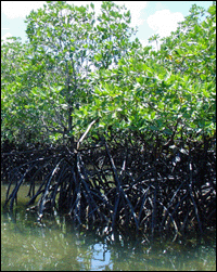
A rank of 10 represents shorelines most likely to be damaged by oiling. Examples include protected, vegetated wetlands, such as mangrove swamps and saltwater marshes. Oil in these areas will remain for a long period of time, penetrate deeply into the substrate, and inflict damage to many kinds of plants and animals. The photo at right shows oil coating a significant portion of a mangrove swamp.
Note: Follow the links along the top of the page to see the full list of shoreline sensitivity rankings and an in-depth example of an ESI shoreline with a rank of 10A. You can also visit our photo collection, ESI Shoreline Types, to see photos of many of the shoreline types.
Classifying Shorelines for ESI Maps
To assign each shoreline a rank from 1 to 10, ESI map developers use information and observations from a combination of sources:
- Overflights
- Aerial photography
- Remotely sensed data
- Ground truthing (visits to individual shorelines to assess aerial observations)
- Existing maps and data
Establishing Shoreline Rankings
ESI shoreline rankings are defined using factors that influence sensitivity to oiling, including:
- Relative exposure to waves and tidal energy
- Biological productivity and sensitivity
- Substrate type (grain size, permeability, trafficability, and mobility)
- Shoreline slope
- Ease of cleanup
- Ease of restoration
More Information about ESI Maps
Anatomy of ESI Maps: Learn about the basic elements of ESI maps.
Biological Resources: Learn how ESI maps categorize and display oil-sensitive animals and their habitats, and habitats that are themselves sensitive to spilled oil (such as coral reefs).
Human-Use Resources: Learn how ESI maps categorize and display the location of human-use resources (such as public beaches) that are vulnerable to oil spills, or that could be used as access points for oil spill cleanup.
Related Publication
Oil Spills in Mangroves: Planning and Response Considerations: A 2002 report summarizing current research on mangrove ecosystems for spill response decision makers.