Coast Survey’s Operational Forecast System Informs Shipwreck Oil Spill Scenarios
Submitted by ryan.v.smith on
 An official website of the United States government. Here's how you know we're official.
A .gov website belongs to an official government organization in the United States.
A small lock or https:// means you’ve safely connected to a .gov website. Share sensitive information only on official, secure websites.
Submitted by ryan.v.smith on
Submitted by ryan.v.smith on
Submitted by ryan.v.smith on
Submitted by ryan.v.smith on
Submitted by ryan.v.smith on
With the latest release, ERMA has transitioned to a new data loader that significantly enhances the display of external data streams, such as live weather. Previously, data from external sources offered limited options for editing and querying. The new data uploader creates a table "copy" of the feed, which supports a wider variety of data types. This allows us to customize map symbology, calculate statistics for display in dashboards, and query data for these external data streams. Even though a copy is being used, ERMA still automatically updates the data and refreshes the table copy.
Within the Dashboard map card, ERMA users can now filter cards based on a custom-drawn polygon. This feature enables users to draw and select an area on the map to improve the relevance of the metrics and data showcased in the dashboard. This selection allows the dashboard to filter and display data within the defined region, making it easier for users to analyze information that is most pertinent to their needs.
For example, in the screenshot below of an ERMA dashboard displaying active cases from NOAA’s Damage Assessment, Remediation, and Restoration Program, users can draw an area of interest by selecting “Add” at the top of the map card.
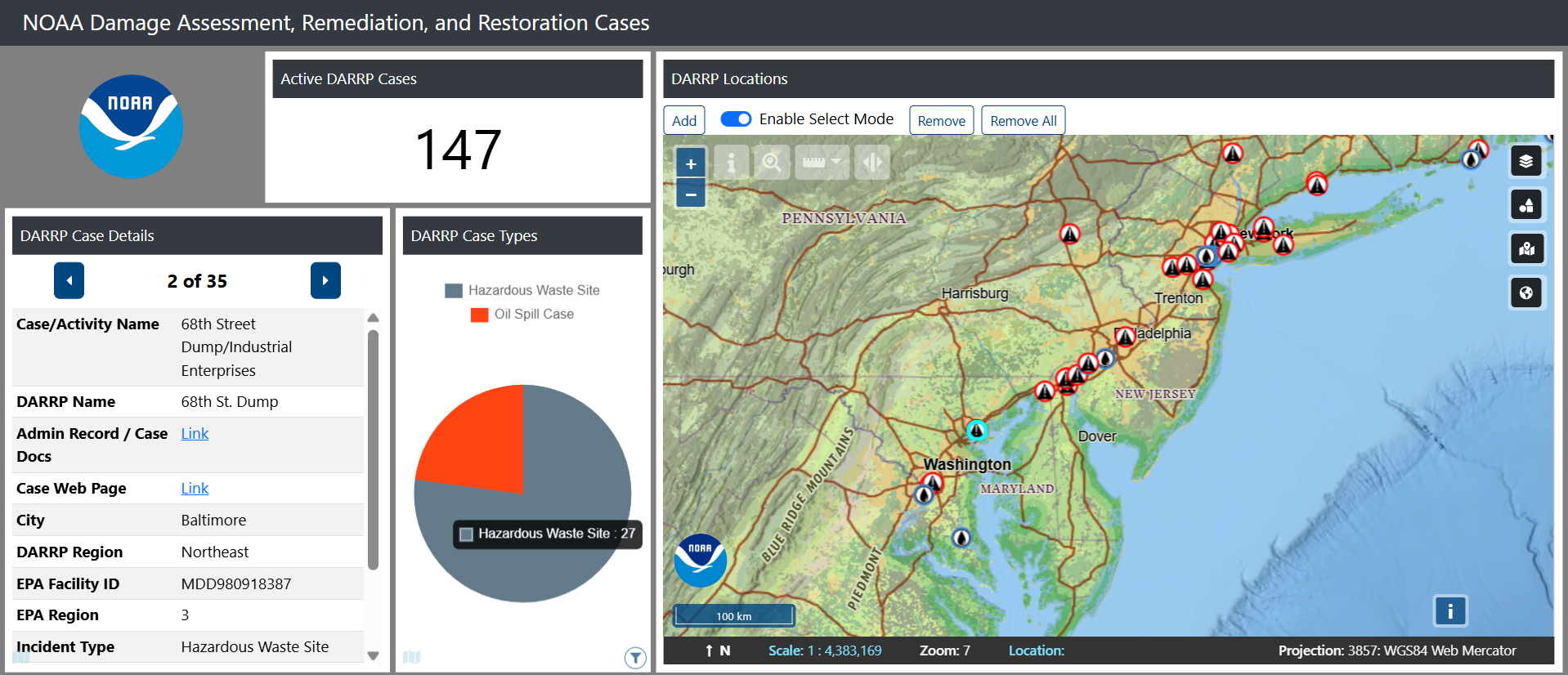

With the area of interest now drawn, use select mode to modify or highlight specific drawings and remove them, as needed. Cards on the left will change only to reflect the sites chosen in the area of interest. This is also reflected at the bottom left of the card with the rectangular icon.
The active DARRP cases card does not have this icon, so nothing has changed with the area of interest polygon filter added. This new feature ensures that your chosen area of interest is reflected across chosen dashboard cards, making analysis more intuitive and tailored to user needs.

Submitted by ryan.v.smith on
Submitted by ryan.v.smith on
Submitted by ryan.v.smith on
Submitted by ryan.v.smith on
MAR. 24, 2025 — Under a five-year operational agreement, NOAA's Office of Response and Restoration (OR&R) and the U.S. Coast Guard (USCG) have committed to using OR&R’s web-based geographic information system tool ERMA® as the common operating picture for oil spills, related disaster support functions, and training. A common operating picture is a continuously updated overview of an incident compiled throughout an incident's life cycle, providing real-time situational awareness across all levels of incident management and across jurisdictions.
To support this interagency agreement, OR&R and partners have developed best practices and training materials to aid USCG pilots and other responders in effectively collecting and delivering imagery for oil characterization and mapping. This effort also identified tools to produce shore-based and open-water image maps and mosaic imagery that meet NOAA standards and requirements for data packaging. Commonly used in remote sensing, mosaic imagery is a technique where a series of adjacent, overlapping images—typically aerial or satellite photos—are “stitched” together to create a single, seamless image that provides an easy to interpret overview of a large area.
OR&R and partners recently released these resources in the form of two comprehensive job aids, titled "Oil Spill Response Uncrewed Aircraft Systems (UAS): Guidance and Training," and "Oil Spill Response Data Management, Storage, and Delivery Guidance.” These resources cover every stage of response operations for the use of UAS use for shoreline and on-water spill response—from mission planning and data collection to image mapping and short and long-term data storage—ensuring seamless integration with NOAA systems like the Data Integration Visualization and Reporting (DIVER) warehouse and ERMA.
Key highlights of the new resources include training materials for USCG pilots to capture imagery for oil characterization and mapping; tutorials and a quick reference matrix for selecting optimal remote sensing tools based on specific response needs, and updated resources integrated into USCG Aviation Training Center programs and UAS flight Operations protocols.
These job aids expand OR&R's resource library, including the Open Water Oil Identification Job Aid for Aerial Observation, published in 2016 to standardize language and streamline assessments of oil appearance and distribution on water. Together, these tools equip response teams with the knowledge and resources to act swiftly and effectively during critical situations.
Funding for the Oil Spill Response Uncrewed Aircraft Systems (UAS) Guidance and Training Job Aid was provided by the USCG Great Lakes Oil Spill Center of Expertise (GLCOE). This job aid was developed by Research Planning, Inc. in close collaboration with USCG’s GLCOE and NOAA OR&R.
.jpg "Nadir images, shown as \"red kites,\" are stitched together into a “mosaic” image map from data collected by U.S. Coast Guard small UAS and posted to the ERMA® common operating picture, providing situational awareness and decision support.")
 Guidance and Training.")
MAR. 24, 2025 — The Trajectory Analysis Planner, or TAP, is an important tool in the NOAA Office of Response and Restoration (OR&R)’s suite of oil spill response and planning tools.
TAP estimates the probability that an oil spill from potential sources might threaten specific shorelines, including how long it might take for spilled oil to arrive onshore, which locations could be most heavily impacted, and how much oil might threaten a location. These results help the U.S. Coast Guard (USCG) and state and local responders to prepare for and limit environmental damage from potential oil spill events.
With funding from and in collaboration with the USCG Great Lakes Oil Spill Center of Expertise (GLCOE), OR&R has developed a new TAP project for Lake Erie simulating spills from 20 potential spill sites in the Lake Erie area—including 13 shoreline sites where oil is stored or transferred and seven sites in shipping lanes where incidents could occur.
Implementations of TAP analyze hundreds of trajectory runs of OR&R’s GNOME (General NOAA Operational Modeling Environment) tool, driven by modeled wind and water currents. Unique to the new Lake Erie TAP is the incorporation of ice concentration over a long time record.
An important advancement for Lake Erie TAP is that the effects of ice on oil transport are included in the model. Ice cover, shown to limit the transport of spilled oil, is highly variable on Lake Erie. Including this variable in the analysis aids in the development of realistic local-area contingency plans for oil spill response.
The USCG GLCOE is mandated to identify gaps in oil spill research as it relates to the Great Lakes; conduct research, development, testing, and evaluation of response technologies and techniques; and educate and train responders in USCG District 9. This latest TAP project joins several other related advancements in the Great Lakes region.
“The addition of Lake Erie to NOAA’s WebTAP affords a new level of open access for contingency planners, community members, and anyone concerned about the possibility of oil spills in Lake Erie from known shoreline-based points or hypothetical maritime accidents out in the shipping lanes,” says USCG GLCOE Research Scientist Matt Alloy, Ph.D., who oversaw the project. “The addition of three different views—all-season, without ice present, and with ice present—demonstrates the need for contingency planning to account for seasonal factors such as ice cover.”
Oil spill responders and planners can view Lake Erie TAP results within OR&R’s WebTAP viewer.

Submitted by ryan.v.smith on
Submitted by ryan.v.smith on
Submitted by ryan.v.smith on
Submitted by ryan.v.smith on
Submitted by ryan.v.smith on
Submitted by ryan.v.smith on
Submitted by ryan.v.smith on
Submitted by ryan.v.smith on