Back to top

NOAA Launches ERMA Mapping Tool for Responding to Arctic Oil Spills

Short title: 
NOAA Launches ERMA Mapping Tool for Responding to Arctic Oil Spills

JULY 31, 2012 — The uncertain, rapidly changing conditions of the Arctic Ocean call for emergency responders to take extra precautions in preparing for the possibility of a remote oil spill. Because of this, NOAA's Office of Response and Restoration, along with the Department of the Interior’s Bureau of Safety and Environmental Enforcement (BSEE), have launched an Environmental Response Management Application (ERMA®) for the Arctic region.

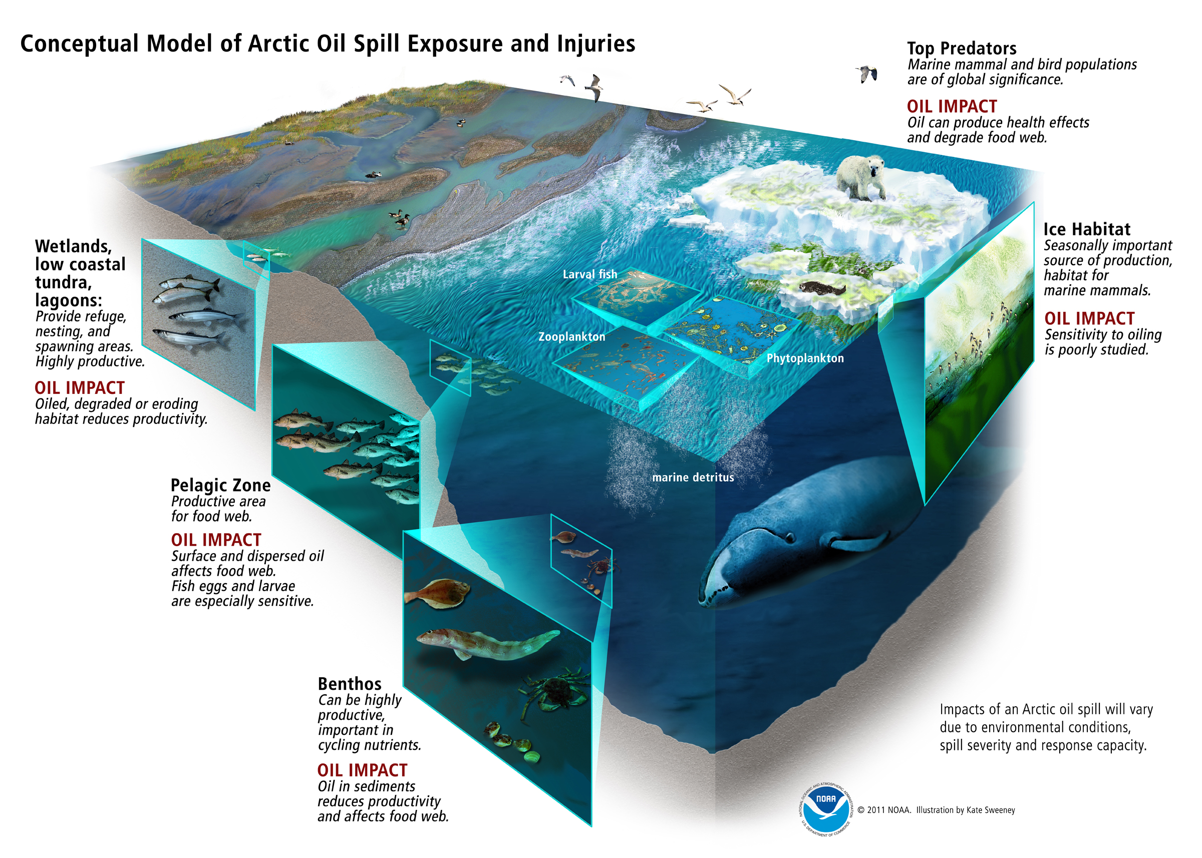
Arctic ERMA, the same interactive online mapping tool used by federal responders during the Deepwater Horizon/BP oil spill, will help address the many complex challenges the Arctic presents. This comes at a key time for the area, as growing ship traffic and proposed energy development, including offshore drilling, are increasing the risk of oil spills. ERMA brings together all of the available information needed for an effective emergency response in the Arctic. In an emergency situation, ERMA is equipped with constantly updated oceanographic observations and weather data from NOAA as well as critical information from BSEE and other federal and state response agencies. Depending on the need, responders can further customize the tool with environmental, logistical, and operational data, such as areas where sensitive species may be, fisheries may be closed, or navigation may be restricted.

"Arctic ERMA builds on the lessons we learned on usability, data management, and data visualization from the Deepwater Horizon/BP disaster," commented Dr. Amy Merten, OR&R Spatial Data Branch Manager. "The Arctic ERMA team is thrilled to work with our diverse group of partners, ranging from Alaskan village elders to federal agencies, as they challenge us in how we share data and visualize information that can improve our collective oil spill preparedness. The Arctic ERMA site is now live, but it's a living work in progress."

Dr. Merten led the team developing Arctic ERMA. Integrating and synthesizing data—some in real time—into a single interactive map, ERMA provides a quick visualization of the situation, improving communication and coordination among responders and environmental stakeholders. NOAA developed Arctic ERMA to address escalating energy exploration and transportation activity in the region, which increases the risk of oil spills and other accidents. The Alaska Ocean Observing System; the State of Alaska; the University of Alaska, Fairbanks; the University of New Hampshire; and Alaska’s Northwest and North Slope Arctic Boroughs are working with NOAA to keep this database current with information as it becomes available.

Arctic ERMA pulls into one platform data such as the location, extent, and concentration of sea ice; locations of ports and pipelines; and vulnerable environmental resources. This tool also includes cultural and subsistence resources based on traditional and local knowledge. In addition to providing local and natural resource information, BSEE has helped improve access to key environmental, commercial, and industrial data sources throughout lease areas in the Arctic. BSEE and other organizations will optimize real-time sensors to feed the data directly into ERMA during both potential oil spills and exercises simulating the release of hazardous materials. You can view Arctic ERMA online at https://www.erma.unh.edu/arctic. Earlier this summer, NOAA, BSEE, and the U.S. Coast Guard used Arctic ERMA during an industry-sponsored training exercise simulating an oil spill in the Chukchi Sea.

"It's an incredibly popular tool," said John Whitney, NOAA's Scientific Support Coordinator for Alaska. "My colleagues responding to oil spills in local, state, and federal government as well as industry continue to give very positive feedback about how valuable Arctic ERMA will be when they are trying to get information about a spill."

Arctic ERMA is the product of a partnership among NOAA's Office of Response and Restoration, NOAA's Office of Ocean and Coastal Resource Management, the Oil Spill Recovery Institute, DOI's Bureau of Safety and Environmental Enforcement, and the University of New Hampshire's Coastal Response Research Center. Besides the Arctic, ERMA is currently available for seven other geographic regions. The launch of Arctic ERMA is part of ongoing efforts by the Interagency Working Group on Coordination of Domestic Energy Development and Permitting in Alaska, which President Obama established in July 2011. This working group aims to coordinate the federal agencies responsible for overseeing the safe and responsible development of onshore and offshore energy in Alaska. Read the press release.

Ice and open water in the Beaufort Sea north of Alaska.
Ice and open water in the Beaufort Sea north of Alaska. (NOAA)
Aerial view of belugas in formation in the Chukchi Sea.
An aerial view of beluga whales, a species which may be vulnerable during an Arctic oil spill, in formation in the Chukchi Sea. (NOAA)
Node Weight: 
5

What NOAA Does for the Beaches of Brigantine

Short title: 
What NOAA Does for the Beaches of Brigantine

This is a post by Vicki Loe, Communications Coordinator for the Office of Response and Restoration. JULY 27, 2012 — Imagine your first trip to the ocean: walking along a sandy beach, listening to the sounds of waves and shorebirds, appreciating the smell of salt in the wind. I was surprised to read recently that beaches only gained popularity as places to relax and enjoy during the past century. Before that, according to author John Gillis, the coast was associated with ship wrecks, danger, and the hard labor accompanying fishing and maritime industry. This trend changed when beaches became more accessible, and people began to see the shore as a refuge and even "sanctuary."

My family vacationing on Brigantine in the 1960s.
My family vacationing on Brigantine in the 1960s. (Vicki Loe)

I still return to the same beach in Brigantine, New Jersey, which I visited every year as a child. I am happy to say that, in spite of the increased residential development of that island, it seems not much has changed since I started vacationing there in the 1960s. However, the future of our beaches is uncertain when faced with threats such as climate change and sea level rise, severe hurricanes, overdevelopment, oil spills, and marine debris. With all of this in mind during my annual visit there last week, I looked at the Jersey shore with new eyes. I realized how appreciative I am of the work that NOAA and other organizations do to preserve our beaches so that future generations can continue to enjoy them the way I have been able to. Brigantine is only one of the many small ocean communities that generations of Americans look forward to visiting along our coasts each year. It is a barrier island just north of Atlantic City. Settled in 1890, it is now home to nearly 9,500 residents. The island is less than seven miles long, with the entire northern third of the island devoted to a wildlife refuge.

Guidelines for visitors reduce the risk of injury or stress to the North Brigantine Natural Area.
Guidelines for visitors reduce the risk of injury or stress to the North Brigantine Natural Area. (NOAA)

Uninhabited by humans, the refuge is composed of sand dunes, maritime forest, and tidal marsh. During the summer visitors can see a variety of endangered birds, including Piping Plover, Black Skimmer, American Oystercatcher, and Least Tern. When I was there last September, I watched a pod of bottlenose dolphins playing near the shore. That was shortly after Hurricane Irene made landfall near Brigantine on the morning of August 28, causing significant beach erosion and flooding. In the developed area to the south, most of the beaches are guarded during the day in the summer to keep swimmers safe. In the evenings, after people have gone home with their umbrellas and beach chairs, the remainder surf, fish, and walk the beach. Boating and recreational fishing are a big part of life on the bay side of the island. What does NOAA do to protect coastal areas like this around the country? The National Weather Service provides valuable information on weather conditions, including severe weather warnings. Recently, they helped guide the development of a smartphone application that gives the U.S. Coast Guard, beach lifeguards, and researchers a way to report and receive up-to-date warnings on dangerous rip currents, which have been a particular problem for swimmers this past year.

A young girl goes surf fishing with her father in the early evening. (NOAA)
    </div>
A young girl goes surf fishing with her father in the early evening. (NOAA)

NOAA also provides nautical charts for the coastal waterways surrounding islands like Brigantine to ensure safe navigation for commercial and recreational boating and fishing as well as commercial shipping. NOAA's Office of Response and Restoration works closely with the U.S. Environmental Protection Agency on hazardous waste sites in coastal areas to protect human health and minimize damage to NOAA marine resources. When an accident or hazardous substance release occurs, NOAA's Damage Assessment, Remediation, and Restoration Program works to assess injury and implements rehabilitation and restoration. Additionally, the Office of Response and Restoration has customized an online mapping tool called ERMA® (Environmental Response Management Application) for this part of the Atlantic coast. ERMA integrates data such as ship locations, weather, and ocean currents, in a centralized, easy-to-use format for environmental responders and decision makers. This tool would be especially valuable in the case of an oil spill, for example. The NOAA Marine Debris Program provides education on the harm caused by man-made litter polluting the ocean and coasts. Even this year, beaches not far from Brigantine reported sightings of medical waste washing up near the shore. The program also provides valuable information to fishers on the proper disposal of monofilament fishing line, which can entangle and injure birds and other wildlife.

NOAA Scientific Support Coordinator Frank Csulak.

Through a partnership with NOAA's National Marine Fisheries Service, the Marine Mammal Stranding Center (based on Brigantine) responds to marine mammals and turtles in distress along all of New Jersey's waterways and oversees their rehabilitation and release back into the wild. Frank Csulak is a good example of one of the many individuals who has devoted his career to the preservation of our coastal resources. Csulak is NOAA's Scientific Support Coordinator and has worked for the Office of Response and Restoration in New Jersey for years. Raised on the New Jersey shore, he is the primary scientific advisor to the U.S. Coast Guard for oil and chemical spill planning and response in the area. Through his tireless work, he helps reduce the influence of pollution on the waterways and shores of the Mid-Atlantic states. So, the next time you visit the Jersey shore, you can thank Frank Csulak, NOAA, and our many partners for delivering another beautiful day at the beach.

Kids play in the sand the same way they have for generations. (NOAA)
Kids play in the sand the same way they have for generations at Brigantine, New Jersey. (NOAA)
Node Weight: 
5

Waking up to our Relationship with Oil

Short title: 
Waking up to our Relationship with Oil

This is a post by Vicki Loe, Communications Coordinator for the Office of Response and Restoration. JULY 17, 2012 -- When I think about oil consumption, I immediately think of gasoline and how much I drive. And I often feel pretty good about it because I drive a relatively fuel-efficient car. But oil is part of plenty of other products in our lives too. Seattle, the city in which I live, recently has banned plastic bags, which are made from oil, and also prohibits restaurants and grocery stores from using Styrofoam (oil-based) containers for take-out food. A lot of people would agree that society's heavy dependence on oil has some negative consequences, which means we are happy about improving fuel efficiency and avoiding Styrofoam cups. But when I look over a list of everyday items made from oil, I am struck by how many of them we might use just in the first hour of a typical day.

For starters, the pillow I sleep on likely contains oil products. I wake up every day to the sound of my iPhone alarm at 6:30 a.m., and the phone's parts and the plastic encasing wouldn't exist without oil. It's a similar story for my shower curtain, shampoo, and bath soap. My toothbrush, toothpaste, and the container that holds my floss are made of oil. Same goes for my deodorant and moisturizer. My hair dryer and brush are plastic, so we can add them to the list. Lots of cosmetics contain oil, so if I wear lipstick or nail polish, there’s another one. If the clothes I put on contain synthetic fibers or my shoes have rubber soles, they too contain oil. So I grab my sunglasses (made of plastic) and head for my car, which has plastic parts, enamel, and tires that all were derived from oil, and—we can't forget—the gasoline that still powers it, however efficiently. By now, it’s 7:30 a.m., and I have used at least 20 products that are manufactured with oil, and I haven’t even made it to the coffee shop yet, where, thankfully, my coffee will come in a paper cup (but with a plastic lid).

Because oil plays such a huge role in most of our lives in the U.S., companies are drilling and transporting a lot of it in marine waters. That means that when accidents happen, oil can—and does—get spilled into the marine environment.

Scientists at the Office of Response and Restoration prepare for and respond to these oil spills: forecasting the movement and behaviors of spilled oil and chemicals, evaluating the risk to natural resources, and recommending the best cleanup measures. That means that we need to understand oil in order to deal with it properly.

Our society's relationship with oil is complex. For something that is so pervasive in our lives, many of us actually do not know much about it. In a special series on this website over the next several months, we will delve into a variety of topics, including what oil actually is, what makes it so useful, and why it can be so toxic in the marine environment.

Protest sign reading 'spOILed.'
Credit: derek_b; used under Creative Commons Attribution 2.0 Generic (CC BY 2.0) License
Beach open: Avoid oil and wildlife sign.
Credit: Lisle Boomer; used under Creative Commons Attribution-NoDerivs 2.0 Generic (CC BY-ND 2.0) License
Node Weight: 
3

Salmon Habitat Successfully Restored after 2006 Diesel Spill in Washington's Cascade Mountains

Short title: 
Salmon Habitat Successfully Restored after 2006 Diesel Spill in Washington's Cascade Mountains

JULY 13, 2012 — Salmon in Washington's White River watershed should be breathing (through their gills) a collective sigh of relief. A mile of their habitat on the Greenwater River in the Cascade Mountains finally has returned to a more natural state.

This restoration project is compensating for a diesel spill in nearby Silver Creek when a faulty pump overfilled a fuel tank and despoiled the area on November 3, 2006.

This small 200-gallon operating, or "day," tank was part of a Puget Sound Energy generator station that supplies backup power to the nearby Crystal Mountain ski area.

Normally, the system senses when the day tank is low and fills it by pumping fuel from large underground tanks, automatically shutting down the flow of diesel when the day tank is full.

On that November day, however, a system failure sent an extra 18,000 gallons of fuel gushing through the day tank from three 12,000-gallon underground tanks. The wave of diesel eventually seeped underground into Silver Creek, where it not only affected endangered Chinook salmon and bull trout but at least five miles of the creek and 16 acres of wetlands.

NOAA and our co-trustees evaluated how extensive the environmental injuries were and recovered damages from Puget Sound Energy. The trustees then worked with local partners to carry out restoration activities, which are now complete. The projects emphasized Chinook salmon and their river habitat in the White River watershed (where Silver Creek is located).

The Greenwater River floodplain project rehabilitated natural river and floodplain processes in order to expand where and how salmon navigate the White River watershed. According to the Fish and Wildlife Service in Washington, "This project removed road fill along the Greenwater River and incorporated large woody material into the channel as engineered log jams."

Historically, log jams were prevalent in Pacific Northwest rivers [PDF] and would help slow and redirect a river's straight, fast-moving currents. The benefits for salmon are two-fold: This action chisels deep pools and pockets into the riverbed, which adult and young salmon need to feed and find refuge from predators, and it also overflows some water outside of the main river channel, creating slower-moving tributaries perfect for older salmon as they prepare to spawn. Engineering log jams through restoration projects like this one helps recreate these benefits for salmon [PDF].

Two key partners in this project's efforts were South Puget Sound Salmon Enhancement Group and the Mt. Baker-Snoqualmie National Forest.

Crews place large wood material which will become engineered log jam habitat for
Crews place large wood material which will become engineered log jam habitat for salmon in the Greenwater River. (South Puget Sound Salmon Enhancement Group)
Returning salmon swim through the new engineered log jam habitat.
Returning salmon, possibly a male and female preparing to spawn, swim through the new engineered log jam habitat along the Greenwater River in Washington. (South Puget Sound Salmon Enhancement Group)
Node Weight: 
7

How Would Chemical Dispersants Work on an Arctic Oil Spill?

Short title: 
How Would Chemical Dispersants Work on an Arctic Oil Spill?

JULY 9, 2012 — If there were a huge oil spill in the Arctic, would chemical dispersants work under the frigid conditions there? And once dispersants break down oil into smaller droplets, how toxic are the oil and chemicals to key species in the short Arctic food web? Would the dispersed oil and dispersant actually biodegrade in cold Arctic waters? With Shell currently on track to drill several exploratory wells in the Chukchi and Beaufort Seas this summer, these are very timely questions—and finally, we are beginning to find some answers.

For the last three years, a special oil industry research group (called a "joint industry program") has been trying to resolve these questions before any major oil exploration, development, and production happens off the northern Alaskan Arctic coastline. Lead scientists Dr. Jack Word of Newfields Environmental (Port Gamble, Wash.) and Dr. Robert Perkins of University of Alaska, Fairbanks, coordinated this research program to determine the viability of using dispersants on Arctic Ocean oil spills.

Conceptual model of an Arctic oil spill's impacts on marine food webs.
The illustration, not associated with this study, shows potential oil spill impacts to wildlife and habitats in the Arctic Ocean. Click for larger view. Credit: NOAA/Kate Sweeney, Illustration. Read on our blog about the process of developing this model.

Aiming for as realistic Arctic conditions as possible, they captured arctic zooplankton (krill and Calanus copepods, which are tiny marine crustaceans) as well as larval and juvenile fish (arctic cod and sculpin) from the coastal waters of the Beaufort Sea. These organisms are key players in the Arctic food web and culturing them in order to conduct toxicity tests hopefully would reveal how negative impacts from oil and dispersants could cascade through the ecosystem. The researchers also conducted toxicity and biodegradation tests in actual waters collected from the Beaufort Sea. Five oil companies were pooling their talents and financial resources to conduct these tests and gather information: Shell, ConocoPhillips, Statoil, ExxonMobil, and BP.

NOAA's Scientific Support Coordinator for Alaska, John Whitney, was fortunate enough to serve on a unique, yet very important, part of the group: the Technical Advisory Committee, which is composed of non-industry technical and non-technical stakeholders. We met once a month to discuss the results and advise them on ongoing scientific tests. Drs. Word and Perkins and their colleagues recently presented the results of this research at a workshop in Anchorage, Alaska. The workshop began with Tim Nedwed of ExxonMobil making a strong case for immediate and robust access to all the major oil spill response options—mechanical methods, in situ burning, and dispersants—in order to deal with a large oil release in the Arctic or any other location.

Mechanical methods (e.g., skimmers) and in situ burning typically encounter spilled oil at low rates, historically removing only 5% to 15% of the oil on the water's surface. This makes chemical dispersants a very attractive option when approaching a big spill using a large aircraft (such as a C-130) to deliver dispersants. After all, Dr. Nedwed pointed out, the ultimate goal of dispersants is to deliver a significant boost to the rate of oil biodegradation that happens naturally after most oil spills. Here are some of the major findings from their research:

  1. Arctic marine species show equal or less sensitivity to petroleum after exposure than temperate (warmer water) species.
  2. The Arctic test organisms did not show significant signs of toxicity when exposed to recommended application rates of the dispersant Corexit 9500 by itself, which also tends to biodegrade on the order of several weeks to a few months.
  3. Petroleum does biodegrade with the help of indigenous microbes in the Arctic’s open waters under both summer and winter conditions.
  4. Chemical dispersants more fully degraded certain components of oil than petroleum that was physically dispersed (for example, from wind or waves breaking up an oil slick).
  5. Under various scenarios for large and small oil spills treated with Corexit 9500, the effects on populations of arctic cod, a keystone species in the Arctic, appeared to be minor to insignificant.

This workshop garnered attention from the oil industry, government regulatory and natural resource agencies, academia, Alaska North Slope residents, private consultants, and non-governmental organizations. It concluded with a brief discussion of Net Environmental Benefit Analysis, a scientific process of weighing the costs against the benefits to the environment, with emphasis on the importance of making this process both science-based and, at the same time, compatible with listening to the subsistence Alaska Native population, a significant and valuable voice in the Arctic.

An arctic cod rests in an ice-covered space.
An arctic cod, a key part of the Arctic food web, rests in an ice-covered space in Alaska's Beaufort Sea, North of Point Barrow. This species was one of the subjects of the research program on dispersant effects in the Arctic. (Shawn Harper/Hidden Ocean 2005 Expedition: NOAA Office of Ocean Exploration)
Node Weight: 
5

How Is Japan Tsunami Marine Debris Cleaned up on the West Coast?

Short title: 
How Is Japan Tsunami Marine Debris Cleaned up on the West Coast?

JULY 2, 2012 — Marine debris: This persistent, global problem has received a lot of attention lately. Over the past couple months, debris from the March 2011 tsunami that struck Japan has started to wash ashore on the West Coast. Items such as a fishing boat, an intact Harley Davidson motorcycle, a soccer ball, and a 66-foot dock have been identified and confirmed as tsunami-related debris. These items were traced back to the devastating event, and in the case of the soccer ball, the owner, 16 year-old Misaki Murakami, was reunited with his personal memento given to him by his third grade classmates.

The challenge with all marine debris, including debris from the tsunami, is that it is difficult to trace it back to its origin with certainty. And marine debris, regardless of the source, poses environmental and safety risks and can impact commerce and recreation. So, how is debris handled? It depends on two factors: type and location.

Large pieces of marine debris that pose a hazard to navigation are handled by the Coast Guard. One large item, the dock that washed up in Oregon, is being removed by the state. Oregon Parks and Recreation reports as of June 26, 2012: "The derelict dock at Agate Beach will be dismantled and removed starting the week of July 30 ... Ballard Diving and Salvage (Vancouver, Wash.) has been contracted to complete the work for $84,155. The work will take up to seven days."

The U.S. EPA, Coast Guard, the state, or local responders remove hazardous debris found on the beach, such as oil or chemical drums. However, the vast majority of marine debris, small and inert items such as plastic bottles, different types of packaging, buoys, and Styrofoam, are cleaned up by volunteer groups. Here's a case in point: The southwestern coast of Washington state has been impacted by thousands of pieces of small debris—the most prevalent being Styrofoam. Volunteer groups like Grass Roots Garbage Gang have tackled and removed the influx of tons of marine debris from the beaches along the Long Beach Peninsula.

The group mobilized volunteers along miles of shoreline and has packed hundreds of garbage bags with debris. Washington state is also assisting by deploying Washington Conservation Corps teams in a cleanup effort, and in Oregon, the state has set up dozens of disposal stations along the coast. It's important to remember that marine debris is an everyday problem, and its impacts are far-reaching. And, it is thanks to these volunteers and the commitment of West Coast state agencies, nonprofits, supporting industries, federal, local,and Tribal governments that marine debris will be removed as much as possible.

Styrofoam found on Washington's Long Beach Peninsula.
Styrofoam found on Washington's Long Beach Peninsula during the Grass Roots Garbage Gang cleanups. (Ellen Anderson)
Dock washed ashore.
The 66-foot-long floating dock from Japan which washed ashore in Oregon more than a year after the 2011 tsunami. The state is coordinating its removal. (Oregon Parks and Recreation Department)
Node Weight: 
4

Living in the Age of Plastic: Conserving Plastic vs. Conserving the Environment from Plastic

Short title: 
Living in the Age of Plastic

JUNE 28, 2012 — Today, we live an era dominated by plastics—versatile, ubiquitous, "disposable" plastics. In this "Age of Plastic," enter Odile Madden, a research scientist studying historic plastic artifacts at the Smithsonian's Museum Conservation Institute. Using her training in materials science, Madden works to understand the materials—from their condition to their chemical composition—used in Smithsonian exhibits. She preserves these materials for as long as possible so that everyone who visits the museums can continue to enjoy these pieces of cultural history.

The sensitive nature of the work demands non-invasive techniques that will not harm the artifact. It also stands in stark contrast to environmental conservation, which depends on materials that break down quickly and do not stick around a long time. For example, an abandoned fishing net drifting in the open ocean will have a much lower chance of accidentally ensnaring marine life ("ghost-fishing") if it breaks down quickly. The NOAA Marine Debris Program, on the other hand, works on the opposite end of the plastics spectrum from Madden. She and her team of cultural conservationists strive to maintain the integrity of valuable plastic artifacts, while at NOAA we're trying to conserve marine environments by, for example, getting rid of plastic debris.

Madden's continued interest in pursuing the technical and philosophical issues surrounding plastic use prompted her to coordinate the recent interdisciplinary symposium, "The Age of Plastic: Ingenuity and Responsibility." Presentations covered everything from the space program's use of plastics to the history of synthetic fibers. They also examined the challenges of preserving plastic in museums and of recycling plastics at the end of their lifecycles and had an open look at how plastics are perhaps indispensable in science and human health. Nancy Wallace, program director for the NOAA Marine Debris Program, participated in an equally engaging panel discussion, where she highlighted the potential hazards of plastics that unintentionally end up as marine debris. (Unsurprisingly, the negative side of plastics.) Still, two important perspectives emerged from outside the world of marine debris:

  1. The difference between "conservationists": Museums use "conservation" to mean saving materials, while environmentalists use "conservation" to mean saving the natural environment. Museums want the material to last as long as possible while we at NOAA would be happy if plastics degraded quickly into its molecular components: carbon, hydrogen, and oxygen. (Technically, the word "plastic" captures incredible variation in material type and structure. "Synthetic polymer" is more accurate but doesn't have much public cachet.)
  1. The difference in values: The use of a material often defines its value. Materials that are meant to be art are arguably more valuable than materials used in life. Probably few people would disagree that there is an intrinsic difference in a resin sculpture housed at the Smithsonian versus the one-time-use spoon you pick up at the cafeteria. But we must ensure that materials are used and disposed of correctly, in ways that respect their value. Plastics are valuable—they were invented for a reason and serve a lot of fantastic purposes—but have become significantly devalued in today's throw-away culture.
A cellulose nitrate Victorian Black Comb circa 1890.
A cellulose nitrate Victorian Black Comb (ca 1890). Celluloid novelties made to imitate precious materials such as ivory and tortoise shell were popular from about 1880 to the 1930s. (Smithsonian Institution Collections)

There is another, unfortunately ironic, conservation connection. In his keynote speech, Robert Friedel of the University of Maryland pointed out that in the early days of synthetics, objects were created to imitate natural materials. In part, this was done to stop poaching of hawksbill sea turtles for tortoiseshell and elephant tusks for ivory. Materials once used to conserve nature now occur in such quantity that natural environments are at risk from them. Nevertheless, it was clear from this symposium that people care: both about preserving museum artifacts and about the baby albatross that chokes on ingested plastic bits. There are so many different, equally valuable perspectives on the use of plastics. All of these perspectives are needed if we are to move forward, as a society, with a more thoughtful approach to material use and conservation. Find out more about plastic as marine debris, including whether plastic ever "goes away," from the NOAA Marine Debris Program website.

Plastic spoons.
Plastic of the "disposable" variety. (Alex Smith, Creative Commons Attribution 2.0 Generic License)
Node Weight: 
4

The Ship M/V Jireh Runs Aground a Coral Reef in Puerto Rico

Short title: 
The Ship M/V Jireh Runs Aground a Coral Reef in Puerto Rico

JUNE 26, 2012 -- Late last week a small freighter, the M/V Jireh, ran aground on Mona Island, an uninhabited island off Puerto Rico. The 22-square-mile island, an ecological reserve, is about 41 miles west of the main island of Puerto Rico.

NOAA, U.S. Fish and Wildlife Service, Commonwealth of Puerto Rico, and U.S. Coast Guard are focusing on recovering the fuel and oil on board the freighter to minimize the environmental impact.

Efforts are underway to remove about 2,000 gallons of fuel oil from the Jireh. So far, a major oil spill appears to have been averted, but there is concern about the physical impact of the ship itself.

As the ship plowed into the reef, it crushed and toppled corals. Unless restored, these unstable and barren areas may take generations to recover as tiny young coral larvae struggle to find a stable place to attach to the reef. Scientists are currently conducting a survey to see how much coral the ship affected.

[UPDATE JUNE 28, 2012: After surveying the underwater area around the grounded vessel, NOAA divers concluded that the ship caused minimal impact to coral. As of June 27, they were assessing whether any coral colonies or endangered species 300 feet out from the ship might be in its path as salvage teams attempted to refloat and remove it. NOAA would proactively remove and transplant any vulnerable species before salvage operations began.

Response crews have confirmed the Jireh is sound enough for them to go ahead and remove the diesel on board. They have deployed 100 feet of containment boom around the smaller response vessel ready to receive the fuel pumped off the Jireh. They also are removing a variety of oiled cargo from the ship, including mangoes, water bottles, cinder blocks, grain, bags of horse feed, and carbonated drinks.]

An injury doesn't only stem from the grounded vessel. Anchors for the protective boom meant to contain any spilled oil have to be placed carefully to prevent additional damage, and care needs to be taken when the salvage tugs start to rig their own anchors and cables. About 800 feet of oil boom is currently strung around the vessel.

Some emergency actions can be taken to restore the coral reef, but recovery will still be slow. NOAA's Office of Response and Restoration works to minimize those environmental impacts and develop restoration alternatives. If you are interested in other photos showing how we address coral injuries, take a look at the Maitland, Fla., and Cape Flattery, Hawaii, cases.

Mona Island is uninhabited, but there is a lot of shipping traffic nearby, and it has been affected by other ship groundings. In July 1997, the 325-foot container ship Fortuna Reefer ran aground on the south shore of the island, damaging approximately 6.8 acres of coral habitat. In September 1997, NOAA initiated an emergency restoration to the reef dominated by elkhorn coral (Acropora palmata) that was completed by mid-October 1997.

A ship aground on coral reef in Puerto Rico and surrounded by protective boom.
The ship M/V Jireh, run aground a coral reef in Puerto Rico, is surrounded by protective oil boom. Credit: U.S. Fish and Wildlife Service.
Node Weight: 
5

Mapping How Sensitive the Coasts Are to Oil Spills

Short title: 
Mapping How Sensitive the Coasts Are to Oil Spills

JUNE 21, 2012 — The U.S. shoreline stretches 95,471 miles, from the coast of Alaska to the Great Lakes to the Gulf of Mexico. However, these shores vary greatly in type, in how people use them, and in which species of birds, fish, and wildlife inhabit them. These differences affect how sensitive the shorelines are to spilled oil and other environmental hazards.

NOAA works with the federal and state governments to produce Environmental Sensitivity Index (ESI) maps, which identify coastal locations that may be especially vulnerable to an oil spill. This series of maps shows the shorelines, wildlife, and habitat most sensitive to oil, as well as the resources people use there, such as a fishery or recreational beach.

For example, an ESI map in North Carolina might indicate an estuary where piping plovers, a threatened shorebird, nest between March and August. It would also display a color-coded ranking revealing that the saltwater marsh is highly sensitive to oiling and show the presence of and contact information for a nearby marina.

Quick Decisions

When a shoreline is threatened by an approaching oil spill, responders must decide quickly which locations along a shoreline to protect. Making these decisions sometimes requires difficult tradeoffs. Having this valuable information ready beforehand helps spill planners and responders prioritize areas to protect from oil and identify appropriate cleanup strategies.

For NOAA's Office of Response and Restoration, one of our main goals in oil spill response is to reduce the environmental consequences of both spills and cleanup efforts. We help create and maintain ESI maps to facilitate the decision-making process surrounding these efforts. Some of the human-use resources on ESI maps include potential access points and staging areas, including boat launches and airports, which would be useful during an oil spill response.

Pelican escaping oiled waters after the tank ship Eagle Otome spill.
Pelican escaping oiled waters after the tank ship Eagle Otome spill near Port Arthur, Texas, in January of 2010. (NOAA)
Environmental Sensitivity Index maps close-up.
Shorelines on Environmental Sensitivity Index maps are color-coded by sensitivity to oil. Symbols mark localized areas for biological and human-use resources.
Node Weight: 
3

Restoration Amid Hanford's Nuclear Waste and the Largest Environmental Cleanup in the U.S.

Short title: 
Restoration Amid Hanford's Nuclear Waste and the Largest Environmental Cleanup in the U.S.

JUNE 15, 2012 — Recently NOAA's Office of Response and Restoration staff had the opportunity to tour the U.S. Department of Energy’s Hanford Nuclear Reservation, where NOAA is working on the Hanford Natural Resource Damage Assessment (NRDA). The goal of the Hanford damage assessment is to restore the natural resources affected by contamination from decades of nuclear defense activities at the Hanford Nuclear Site. Between 1944 and 1987, Hanford, located in eastern Washington state, produced plutonium for atomic weapons, starting with the "Fat Man" bomb dropped on Nagasaki in 1945.

During the Cold War years, the facilities grew to include nine nuclear reactors and associated processing plants. While producing plutonium for the U.S. defense program throughout the Cold War, billions of gallons and millions of tons of nuclear waste were generated, contaminating the ground around waste sites, the reactor and processing facility buildings, and groundwater. The site accounts for two-thirds of all the high-level radioactive waste in the entire country (by volume). There are 149 large eroding tanks filled with old nuclear waste that is in the process of being transferred into new tanks and eventually will be mixed with glass, a process called vitrification, for stability and permanent storage.

Since 1989, Hanford has been in cleanup mode and is the largest environmental cleanup in the U.S., employing about 11,000 people. Technicians work to mitigate contaminated groundwater before it reaches the Columbia River, which borders the site for 51 miles. They work on demolishing facilities, encasing ("cocooning") old reactors, and burying tons of waste material into huge pits that are lined to prevent contaminants from leaching into the soil. A new waste treatment plant is underway that will handle the vitrification process for the nuclear waste currently stored in tanks. The process of cleaning up is likely to continue for decades.

Burned-out shell of Hanford High School.
Hanford High School as it looks today. It is the only building left from the original town of Hanford, Wash. (Dept. of Energy)

While touring Hanford, it is easy to be struck by the enormity of the site as well as the magnitude of the problem and the range of cleanup activities in progress. The 586-square-mile area is a desert steppe ecosystem mostly covered in grasses and sagebrush, with very few trees. For the most part nothing breaks the horizon but the now sealed-up, tall, windowless, nuclear reactors. There are rolling hills and bluffs along the Columbia River, as well as the sites of two former small towns: Hanford, which gave the larger site its name, and White Bluffs. Both towns were evacuated permanently to make way for the top-secret nuclear project in 1943. All that is left of them is the burned-out cement shell of Hanford High School, outlines of where sidewalks and streets once were, and a bank that had been in downtown White Bluffs. Some former residents return in the summer for a picnic on the site of the vanished communities. For thousands of years before these two small towns existed, the area was inhabited by Native American people who gathered mussels, spear-fished salmon, and hunted the bison that previously roamed there.

The site is still important as a cultural meeting place and fall fishing ground for descendants of the Native people. Also of concern to the Native American people are the more than 600 archeological sites that have been discovered within the Hanford Nuclear site. Three Tribes, as well as representatives from the states of Washington and Oregon, the U.S. Departments of Energy and Interior, U.S. Fish and Wildlife, and NOAA are all involved in the environmental damage assessment. This collective group of trustees operates by consensus to replace lost or injured resources. They face diverse interests as they continue to collaborate throughout this process. A particular challenge of interest to NOAA is whether to initiate environmental restoration in the Columbia River before the full cleanup and damage assessment is complete. For more information on tours of the Hanford Nuclear Site, see the U.S. Department of Energy Hanford Site Tours.

The front face of Hanford's B Reactor, where uranium fuel slugs were loaded.
The front face of Hanford's B Reactor, where uranium fuel slugs were loaded into the reactor when it was operating. The reactor began operating in September 1944; it was shut down from 1946-1948, and then went back into service until 1968. (Dept. of Energy)
Spent fuel rods stored underwater at the Hanford Nuclear Reservation.
Spent fuel rods are stored underwater at the Hanford Nuclear Reservation. (Dept. of Energy)
Node Weight: 
4

Mussel Memory: How a Long-Term Marine Pollution Program Got New Life

Short title: 
How a Long-Term Marine Pollution Program Got New Life

JUNE 11, 2012 — Scraping small black mussels off of slippery rocks in the Pacific Northwest's chilly, wet January weather probably doesn't sound like much fun. However, thanks to the dedicated folks who endure those conditions (and to several other important partners), these mussels and others tested in NOAA's National Mussel Watch Program will keep telling us about water pollution levels and seafood safety for years to come. For example, just last month a fishing boat caught fire and sank near Washington's Whidbey Island. The boat ended up leaking diesel fuel into waters near a Penn Cove Shellfish Company mussel farm, and the company took the precautionary measure of stopping the harvest. NOAA scientists Alan Mearns and Gary Shigenaka rushed to the scene. With help from the shellfish company's co-owner Ian Jefferds, NOAA sampled mussels from six mussel floats and two beach sites and received the lab results of the oil pollution screening a few days later. They confirmed that the mussels had low levels of diesel contamination.

The Washington State Department of Health had shut down all shellfish harvesting in Penn Cove on May 15 and just reopened some areas on June 5. Unfortunately, NOAA didn't have an existing Mussel Watch site in this cove. Nevertheless, thanks to comparable Mussel Watch sites nearby, we have a decent idea of what the contaminant levels in Penn Cove mussels might have looked like before this oil spill. But not long ago this valuable shellfish-monitoring program almost disappeared from Washington waters.

Endangered Research During the past couple years, the Office of Response and Restoration's Alan Mearns has worked together with Dr. Dennis Apeti at NOAA's National Centers for Coastal Ocean Science and Dr. James West at Washington Department of Fish and Wildlife to help revive and expand the National Mussel Watch Program in the state of Washington.

Marshland along the Delaware River.
Penn Cove Shellfish mussel farm floats, with protective floating boom surrounding the site where the fishing vessel sank in the background. NOAA scientists helped sample these mussels for diesel pollution. (NOAA/Alan Mearns)

Under NOAA, the National Mussel Watch Program has been monitoring trends in contaminant levels in the mussels (Mytilus spp.) living in Washington waters since 1986. Regionally, this program has been tracking changing levels of pollution at up to 20 different locations in Puget Sound, the Straits of Georgia and Juan de Fuca, and Washington's Olympic Coast. This provides valuable water quality data on background levels and trends of fossil-fuel byproducts and other chemicals. These include about 50 polycyclic aromatic hydrocarbons (PAHs), which are potentially cancer-causing pollutants.

By sampling mussels, we've discovered that parts of Puget Sound have significantly higher amounts of PAHs than anywhere else in the U.S., including heavily trafficked ports like Los Angeles and San Francisco Bay. However, a steady decrease in funding over the past several years threatened to end NOAA's mussel monitoring in Washington and across the country. As early as 2006, Dr. Mearns was working as a volunteer member of the Snohomish County (Washington) Marine Resources Committee to convince the county, the Stillaguamish Tribe, and the Tulalip Tribe to help save the program by funding and coordinating their own local mussel sampling—and had some success by 2006 and 2007. But that alone wouldn't be enough to save the program. In 2009, Dr. Mearns approached scientists at the Washington State Department of Fish and Wildlife, who evaluate trends in Puget Sound’s environmental quality. Chief Eco-toxicologist Dr. West bit at the opportunity to help and got his department involved.

Volunteer Muscle By the winter of 2009–10, Dr. Mearns and his team of federal, state, and local partners were ready to save the program with the help of citizen scientists. These were the hardy volunteers trained to collect mussels using scientific methods around Puget Sound and on the Olympic Coast. Many of these volunteers are part of Washington State University Beach Watchers, a program active in marine education, research, and stewardship.

Volunteers sample mussels at a Mussel Watch beach site near Edmonds, Wash.
Snohomish County Marine Resources Committee members and Snohomish County BeachWatcher volunteers sample mussels at the Edmonds Jetty Mussel Watch site, one of the National Mussel Watch Program sites. (NOAA/Alan Mearns)

Alongside these volunteers was staff from the Snohomish County Marine Resources Committee and the Olympic Coast National Marine Sanctuary. And of course, Dr. Mearns and his fellow NOAA colleague Debra Simecek-Beatty were out in their rain gear gathering mussels too. From January through March 2010, both old and new collection sites in Washington had been sampled, and the mussels were sent to a NOAA-contracted laboratory for chemical analysis. Then on April 20, 2010, the Deepwater Horizon/BP well blowout caused nearly every qualified pollutant chemistry laboratory in the U.S. to drop everything and support the oil spill response and assessment in the Gulf of Mexico. The Washington samples were ready and waiting but got set aside for more than a year.

Forging Ahead Anxiously awaiting results, but undaunted, Washington Department of Fish and Wildlife began preparing for the next biennial survey in 2012. Thanks to new U.S. EPA funding, they now could expand the Washington program to test mussels at nearly 30 locations, which were sampled this past February. Just last month, they finally received the long-awaited 2010 lab results. Preliminary inspection revealed a new hotspot of oil byproducts in Elliot Bay while several past locations like this disappeared from urban areas. Dr. Mearns has been providing guidance for the data analysis, particularly for the petroleum hydrocarbons (PAHs).

Mussels and barnacles on rip rap rocks at a Mussel Watch site.
Mussels and barnacles on rip rap rocks at a Mussel Watch site. Note also the seaweed, Fucus (popweed), and several dog whelk snails (that prey on mussels). (Snohomish County Marine Resources Committee).

The recent Washington Mussel Watch expansion is now poised to open sampling at 60 sites, including completely new areas, such as the San Juan Islands; to sample during different seasons to pin down big runoff pollution events; and potentially to use a new technique that allows sampling in areas where mussels aren't living already (by placing clean mussels in a bag attached to a buoy anchored at sea). This Mussel Watch triumph of partnerships not only gives scientists and natural resource managers in Washington the ability to track the benefits of pollution management actions, but it also gives them a basis for comparing background contaminant levels in the event of an oil spill like the one near Whidbey Island, Wash. When cleaning up spilled oil, it helps us to know how "clean" any particular place was before oil spilled there.

Person scraping mussels off intertidal rocks at Hat Island.
Kathleen Herrmann of the Snohomish County Marine Resources Committee (MRC) samples mussels at Hat Island, 5 miles offshore of Everett, Wash. (MRC/Lincoln Loehr)
NOAA and Penn Cove Shellfish Co. staff sample raft-grown mussels.
NOAA's Gary Shigenaka and Tim Jones of Penn Cove Shellfish Co. sample raft-grown mussels from one of the numerous culture rafts, five days following the nearby sinking of the derelict vessel, Deep Sea. (NOAA/Alan Mearns)
Node Weight: 
5

Building Relationships out on the Ice in the Arctic Circle

Short title: 
Building Relationships out on the Ice in the Arctic Circle

JUNE 8, 2012 -- It's difficult to appreciate fully the challenges of dealing with an oil spill in Arctic conditions until you venture for yourself above the Arctic Circle to a remote village such as Kotzebue, located on Alaska's northwest coast. There you can see some of those challenges first hand. A handful of Office of Response and Restoration staff recently converged up north to attend a workshop on involving the community not only when responding to oil spills but also when measuring and restoring the resulting damage to natural resources. Due to the prospect of increased ship traffic and offshore oil drilling in Arctic regions, the risk of an oil spill in Arctic waters is growing. As a result, Alaska's Northwest Arctic Borough sponsored this workshop to discuss oil spill response and restoration issues. NOAA attended along with several other state and federal agencies, and the Coastal Response and Research Center facilitated the meeting.

The workshop also included discussions about how to integrate local community knowledge into the newly released Arctic Environmental Response Management Application (ERMA), an online mapping tool that integrates different types of environmental information for decision makers during disasters. Located 33 miles north of the Arctic Circle, Kotzebue is a hub of travel for this area of Alaska, allowing participants from 11 villages in the Northwest Arctic Borough to attend this workshop. During the course of the meeting, community members from Kotzebue and surrounding villages expressed concerns about oil spill response capabilities and how a spill would affect their subsistence lifestyle. These initial discussions are extremely useful in NOAA's efforts to broaden our understanding of how people are so closely tied to and dependent on natural resources in the Arctic—and how we would be able to evaluate those connections in case an oil spill interfered with them. The most important goal of the workshop that we were able to achieve was to enhance relationships and the knowledge exchange between local Alaskan communities and government agencies.

Man in the distance walking on sea ice.
Venturing out onto the ice. (Elspeth Hilton)

One way to picture the value in these relationships is to imagine venturing out onto the vast sea ice next to Kotzebue. This is a thick layer of ice frozen over the Arctic Ocean. Some of us visiting NOAA staff saw snowmobilers and skiers speed across it, and we observed numerous small groups ice fishing on it. Two days later, the first layer of snow on the ice had firmed up, enabling us to walk out onto it without sinking up to our knees in snow. The big question was, How safe was it? We could see some cracks in the ice, but two days ago it was being heavily used. Even though there was no one out on the ice at the time, eventually we deduced that it was safe.

Very timidly, we walked out onto the sea ice, but no issues arose except cold fingers. What we needed and desired, however, was guidance from the locals who knew the ice. Those who live in this amazing corner of the world know the status of the ice and would have been able to direct us if there were any safety problems. This experience, although on a very small scale, can be compared to the objectives of this workshop. One of the central goals was to start building relationships between those who know the local environments with those emergency responders and restoration experts who will need their guidance and expertise if an oil spill does occur.

Overlook of Kotzebue, Alaska.
Overlook of Kotzebue, Alaska. (Elspeth Hilton)
A classic building on the Kotzebue waterfront.
A classic building on the Kotzebue waterfront. (Elspeth Hilton)
Node Weight: 
5

Bringing Urban Waterfronts Back to Life: Philadelphia Edition

Short title: 
Bringing Urban Waterfronts Back to Life: Philadelphia Edition

MAY 18, 2012 -- If you visit the waterfronts of many cities in the U.S., you will find a common scene: abandoned eyesores with artificial, hardened, and denuded shorelines. They attract trash, invasive species, and crime and repel just about everything else. But where some see ecological and economic wastelands, others envision tremendous opportunities for reviving coastal communities. We were there at the invitation of the Delaware River City Corporation and Pennsylvania Environmental Council, two of a series of partners who were interested in transforming this urban wasteland into a jewel—a waterfront park that would provide the public with a rare amenity: safe and attractive access to the Delaware River. It also had the potential to serve as a model for reclaiming blighted city shorelines. At the time, NOAA and co-trustee agencies from Pennsylvania, New Jersey, Delaware, and the U.S. Fish and Wildlife Service were looking for restoration projects that could help offset the environmental impacts from the 2004 release of 265,000 gallons of oil from the tanker M/V Athos I. Some of the oil washed up on these shorelines, and we were interested in options for reversing some of the harm. As we walked around and listened to the park’s proponents, I admit that it was tough to imagine how this dump site, full of concrete rubble and weeds, could be turned into a park. But the more we listened, the more we realized that they had a vision, a plan, and a passion for returning the shoreline to the people. The trustees agreed to partner with the Delaware River City Corporation by contributing part of the settlement from the Athos oil spill to add a living shoreline to the park, including wetland plantings. Now, four and a half years later, I was back on May 14 to witness the grand opening of Lardner's Point Park. This 4.5-acre riverfront oasis is Philadelphia's newest park and includes a river overlook, fishing pier, picnic tables, connections to a trail system, riverbank forest, and a living shoreline with tidal wetlands.

Lardner's Point Park sign.

On that blustery day in May, the visionaries were out in force to recognize the accomplishment of a dream come true, including Philadelphia Mayor Michael Nutter, Rep. Allyson Schwartz, former Rep. Robert Borski, and other state and local officials and community groups. The famous Philadelphia Mummers provided entertainment. Another guest that showed up unannounced was a rare and threatened Pennsylvania red-bellied turtle, which was seen visiting the newly restored shoreline habitat. In an effort to continue this momentum, NOAA is also coordinating with other federal agencies, the city, and community groups in preparing an application for Philadelphia to become an Urban Waters Federal Partnership site, a program under America's Great Outdoors Initiative. We look forward to future successes in restoring urban waterfronts and ecological and economic benefits to more coastal communities. By Tom Brosnan, Communications Branch Chief in the Office of Response and Restoration's Assessment and Restoration Division Editor's note: Learn more about NOAA's longstanding efforts to clean up and restore the Delaware River and see the amazing transformation of Lardner's Point in these before and after photos.

Philadelphia Mayor Michael Nutter.
Philadelphia Mayor Michael Nutter spoke at the opening of Lardner's Point Park, the fresh, new face of urban waterfront. (NOAA)
Red-bellied turtle swimming.
A young red-bellied turtle (a threatened species) enjoys the newly restored habitat at Lardner's Point in Pennsylvania. (Pennsylvania Environmental Council/Rebecca Kennedy)
Node Weight: 
3

Mapping Safety, the Free and Easy Way

Short title: 
Mapping Safety, the Free and Easy Way

This is a guest entry by emergency planner Tom Bergman.

MAY 10, 2012 -- Many of you are familiar with Google Maps or MapQuest, examples of free online mapping tools that have probably saved you from driving around lost for hours. But I bet you haven't heard of another free mapping tool, known as MARPLOT, which has definitely saved more than a few people's lives.

Back in 1986, NOAA and Environmental Protection Agency staff created MARPLOT, along with several other programs in a software suite called CAMEO, to help emergency planners and responders deal with chemical spills. Even today, the CAMEO software programs remain popular tools for hazardous material releases worldwide.

One of these programs, CAMEOfm, gives anyone the ability to create and place custom objects (like a hospital or school) on a MARPLOT map and link those objects to data (like the hospital's emergency contact information) stored in the CAMEOfm database.

But I can tell you that this software doesn't only come in handy when a truck full of chemicals tips over next to a hospital. MARPLOT, when linked up with the database application CAMEOfm, is regularly operated as a free and easy-to-use Geographic Information System (GIS). One of the attractive features of these two programs is that they operate independently of any internet or server connection. This can be critical for responders during emergencies, when internet and cell phone service may simply not be available.

This was certainly the case on March 2, 2012, when a category EF3 tornado struck the Kentucky town of West Liberty with winds between 136–165 miles per hour. When the Urban Search and Rescue team arrived on scene from Lexington, Ky., they discovered that the severe weather had disabled the area's internet and cell phone service.

Fortunately, the local emergency manager was able to supply search and rescue team commander Gregg Bayer with a laptop computer which had MARPLOT installed with local map data and aerial photos of the affected region. They quickly were able to organize their search efforts and create customized maps by drawing search zones and map symbols directly on top of aerial photos. The MARPLOT program was instrumental in helping the emergency responders get familiar with the area, document suspected paths of destruction, and obtain 2010 U.S. Census estimates for the number of people and buildings affected—all without internet, cell phone, or server access.

A month later, on April 4, 2012, an even stronger tornado (rated EF4) ravaged northeastern Oklahoma and southwestern Kansas. Several area counties used MARPLOT and CAMEOfm to track the path of the tornado and then document and manage information related to recovery efforts, including photographs and videos of the storm damage.

Map view of schools possibly affected by severe weather.
In this view of MARPLOT, you can see two schools which might be affected by a severe weather event in Orlando, Fla. Click to enlarge.

Since 2009, a school district in Orlando, Fla., has been making extensive use of these free tools to develop high quality maps for emergency planning activities.

To prepare for Florida's not-unusual hurricanes, the district's emergency manager, Joe Mastandrea, combines school facility information in MARPLOT with predicted storm paths imported from the hurricane-tracking program HURREVAC 2010. This helps the school district know which schools might be affected (and to what degree) by an approaching storm and be ready to keep everyone safe.

Another, completely different, application of this software has started recently in a number of Oklahoma counties: taking inventory of their road signs. The county evaluates each of its road or highway signs using a "reflectometer," an instrument that predicts the sign's anticipated lifespan.

The information from the reflectometer is imported into MARPLOT, which plots the sign's location and allows users to search and display the data for each sign. By tracking when each sign needs to be replaced with a new, more reflective sign, the counties can make roads safer for drivers traveling at night.

In the reality of counties with only 3,000 people and no paid firefighters, emergency staff can't afford to hire GIS specialists (much less the fancy software) to do this kind of work. Fortunately, they can afford to download the free MARPLOT and other CAMEO suite software and easily put it to use.

The CAMEO staff at NOAA and EPA are constantly revising and improving all the CAMEO programs. Do you have your own experiences using the CAMEO programs? You can post and read stories about CAMEO software suite usage at www.cameotraining.org. For more information about obtaining the CAMEO programs, visit http://response.restoration.noaa.gov/cameo and https://www.epa.gov/cameo.

Tom Bergman is the author of the CAMEO Companion and host of the www.cameotraining.org website. Tom is the EPCRA (Emergency Planning and Community Right-to-Know Act) Tier 2 Program Manager for the State of Oklahoma and has been a CAMEO trainer for many years. He has conducted CAMEO training courses in Lithuania, Poland, England, and 43 U.S. states.

Aerial view of tornado damage to downtown West Liberty, Kentucky.
An aerial view of the damage to downtown West Liberty, Ky, after the March 2, 2012, EF3 tornado hit the area. (NOAA/National Weather Service/Allen Bolling)
Node Weight: 
3

Are Your Clothes Shedding Plastic Into the Ocean?

Short title: 
Are Your Clothes Shedding Plastic Into the Ocean?

APRIL 30, 2012 -- When you pull your favorite fleece jacket snugly around you, you probably never think about how it could be contributing to marine pollution. However, recent research has investigated exactly that, exploring whether synthetic fabric products (such as fleece) could be a potential source of microscopic plastic fibers in the ocean and on beaches. While at University College Dublin (Ireland), lead researcher Mark Browne conducted an experiment which included washing fleece clothing and then counting the number of fibers left over in the wastewater from the washing machines. He found that one piece of clothing could yield nearly 2,000 plastic fibers in a single wash—which would wind up not only in the wastewater but eventually in the marine environment. In a complimentary experiment, he explored whether similar plastic fibers end up in beach sediments. His research uncovered that microplastic fibers, mostly polyester and acrylic, are showing up on beaches across the world, whether samples were gathered near sites where wastewater was discharged or not. In other words, teeny plastic fibers from your synthetic clothing could make their way to the ocean. Because synthetics (plastics) can persist for a long time and travel along ocean currents, the topic of microplastic pollution has emerged in the past five years as a cause for concern. The premise and conclusions of Dr. Browne's research are provocative. This study is one of the first of its kind to pinpoint a specific source of microplastic marine debris. Because of the complexity of the topic, we still don’t have good estimates for how much of this debris is out there and how it enters the environment. Dr. Browne's work is a good example of a hypothesis-driven research project that has filled important knowledge gaps in our estimation of what kinds of debris end up on beaches. It has implications for how we could prevent this source of microplastic marine pollution. His research is also timely—an international working group (GESAMP) has just taken up the topic of microplastic debris and will be performing a global assessment of its sources and impacts. More than anything, this research points to the complex nature of marine debris. Who would have thought that plastic particles from our clothing could make their way into the ocean? Unfortunately, there is not a single solution that will fix all the problems associated with marine debris, but good science allows us to find the best options for dealing with them. For now, wash carefully, and educate yourself and others on the issue of plastics in our ocean.

Node Weight: 
4

Getting Ready for Offshore Oil Drilling in Cuba and the Bahamas

Short title: 
Getting Ready for Offshore Oil Drilling in Cuba and the Bahamas

APRIL 27, 2012 -- For the past year, NOAA and the U.S. Coast Guard have been studying the possible threats that new offshore oil drilling activity near the Florida Straits and the Bahamas pose to Florida. For example, the proximity of Cuba's oil fields to U.S. waters has raised a lot of concerns about what would happen if a spill like the 2010 Deepwater Horizon/BP oil well blowout happened. If a large oil spill did occur in the waters northwest of Cuba, currents in the Florida Straits could carry the oil to U.S. waters and coastal areas in Florida. However, a number of factors, like winds or currents, would determine where any oil slicks might go. NOAA's National Ocean Service has more information about how we're preparing for worst-case scenarios there:

The study focuses on modeling the movement of oil in water to predict where, when, and how oil might reach U.S. shores given a spill in this region of the ocean. Models help to determine the threat to our coasts from a potential spill by accounting for many different variables, such as the weathering processes of evaporation, dispersion, photo-oxidation, and biodegradation—all of which reduce the amount of oil in the water over time. Currents and winds also play a role in determining where oil will move in water. For example, there are three major currents that would dominate movement of spilled oil near the Florida Straits: Loop Current, Florida Current, and the Gulf Stream.

If oil did reach U.S. waters, marine and coastal resources in southern Florida could be at risk, including coral reefs and the Florida Keys National Marine Sanctuary, located north of the Cuban drilling sites. We'll be watching the drilling activity there very carefully. If a spill does happen, NOAA will be ready to share our scientific expertise on oil spill response with the U.S. Coast Guard.

A diver explores coral in the Florida Keys National Marine Sanctuary.
A diver explores coral in the Florida Keys National Marine Sanctuary. (NOAA)
Map of potential oil producing areas in the North Cuban Basin.
Potential oil producing areas in the North Cuban Basin. (U.S. Geological Survey)
Node Weight: 
5

Early Restoration to Begin in Gulf of Mexico After Deepwater Horizon/BP Oil Spill

Short title: 
Early Restoration to Begin in Gulf of Mexico After Deepwater Horizon/BP Oil Spill

APRIL 20, 2012 — An estimated $60 million in early restoration projects soon will begin along the Gulf Coast following the nation's largest oil spill, according to the Deepwater Horizon Natural Resource Damage Assessment Trustee Council. "The early restoration projects will drive both ecological and economic renewal," said NOAA trustee Monica Medina, Principal Deputy Undersecretary of Commerce for Oceans and Atmosphere. "Through these and future projects, the trustees intend to build a regional restoration economy." With finalization of the "Deepwater Horizon Phase I Early Restoration Plan & Environmental Assessment," [PDF] eight restoration projects will be implemented in Alabama, Florida, Mississippi, and Louisiana. The projects provide for marsh creation, coastal dune habitat improvements, nearshore artificial reef creation, and oyster cultch restoration, as well as the construction and enhancement of boat ramps to compensate for lost human use of resources. This is the first early restoration plan under the unprecedented April 2011 agreement with BP to fund $1 billion in early restoration projects in the Gulf of Mexico. Meant to address injuries to natural resources caused by the Deepwater Horizon/BP oil spill, the funding enables the trustees to begin restoration before the completion of damage assessment activities. The $1 billion will go towards the following early restoration projects:

  • Each Gulf state—Florida, Alabama, Mississippi, Louisiana and Texas—will select and implement $100 million in projects;
  • The Federal Resource Trustees, NOAA and the U.S. Department of the Interior, will each select and implement $100 million in projects;
  • The remaining $300 million will be used for projects selected by NOAA and Department of the Interior.

"This milestone agreement will allow us to jump-start restoration projects that will bring Gulf Coast marshes, wetlands, and wildlife habitat back to health after the damage they suffered as a result of the Deepwater Horizon spill," said Secretary of the Interior Ken Salazar. During what has been deemed the largest oil spill in U.S. history, NOAA's Office of Response and Restoration provided forecasts of oil movements, advised the U.S. Coast Guard on cleanup operations, produced and maintained the Common Operational Picture, and managed large volumes of data streams and assessed resources threatened by spilled oil. We continue to work with state and federal agencies to document impacts to the Gulf of Mexico’s natural resources and the public’s lost use of them.

Workers in a marsh and boat.
An area of marsh oiled in the Gulf of Mexico during the Deepwater Horizon/BP oil spill. (NOAA)
Node Weight: 
4

Japanese Soccer Ball Lost During Tsunami Washes Up in Alaska

Short title: 
Japanese Soccer Ball Lost During Tsunami Washes Up in Alaska

APRIL 19, 2012 — More than a year and thousands of miles later, a soccer ball washed away during the Japan tsunami has turned up on a remote Alaskan island and eventually could be headed back to the Japanese school grounds it originally came from. An observant beach comber on Middleton Island, in the Gulf of Alaska, found a soccer ball and volleyball [UPDATE BELOW]** with Japanese writing on them.

A school name is stenciled on the soccer ball, and his wife was able to translate the writing to trace it to a school. We have confirmed that the school was in the tsunami zone, but because the school is set up on a hill, it wasn't seriously impacted. This may be one of the first opportunities since the March 2011 tsunami that a remnant washed away from Japan has been identified and could actually be returned to its previous owner. When something gets washed up on a beach, unless it has a unique and traceable identifier, like the registration numbers on a boat, it can be difficult to tell if the item was set adrift by the tsunami, or if it was lost or discarded at sea some other time.

The NOAA Marine Debris Program has been monitoring floating debris from the tsunami for the past year, and some very buoyant items have already made the long journey across the Pacific. The derelict fishing vessel the U.S. Coast Guard ended up sinking off Alaska in early April had drifted at least 4,500 miles before being spotted off Canada's west coast. In addition, a few suspect items like plastic fishing floats used in coastal aquaculture in Japan have washed up ashore. But so far most of the reported items can’t be traced definitively back to the tsunami.

Marine debris is an everyday problem along the Pacific Coast, and buoyant items like bottles and plastics wash up on our coasts from Asia (and other places) all of the time. However, some of the most touching items found so far have been these sports balls from Japan. The story of where the soccer ball was found is also interesting. Middleton Island, Alaska, is by all definitions a very remote place. The 4.5 mile long island in the Gulf of Alaska is about 70 miles from the Alaska mainland, and 50 miles from the nearest island. A few people work on the treeless and windswept island, where they maintain the Federal Aviation Administration (FAA) Radar, Navigation, and Communication facilities there. Bird watching and beach combing are popular recreation activities there. It was David Baxter, a technician at the radar station, who ultimately found the sports balls washed up on the beach.

NOAA is working with the U.S. State Department, the Japanese Embassy, and the Japanese consulate in Seattle to confirm the details of the school connection and to set up a process to return any future items. The soccer ball may be the first identifiable item that could be returned. Unfortunately, the volleyball doesn't have enough information on it for the Japanese consulate to continue investigating a possible owner, although the technician's wife is continuing the search on her own. The loss of life and suffering caused by the tsunami will be felt for generations, and the soccer ball is only one small example of how that event has touched us here in North America. Information on significant marine debris sightings in the North Pacific Ocean and on the coast is a big help to us as we improve our models and predictions about the debris’ paths. If you find an item you think may be related to the Japan tsunami, take a picture, note the location, and report it to us at DisasterDebris@noaa.gov.

**UPDATE (4/24/2012): The soccer ball's owner, 16 year-old Misaki Murakami, has been located and confirmed that this is indeed his ball. He lost everything in the 2011 Japan tsunami and is grateful that this object of sentimental value has been found. He received it in 2005 as a gift from his classmates in third grade before moving to a new elementary school, and one of the messages on the ball reads "Good luck, Murakami!!" (or rather "Hang in there, Murakami!!"). David Baxter and his wife Yumi plan to send him the soccer ball. The volleyball found on the same Alaskan island a few weeks later has been traced to a 19 year-old woman, Shiori Sato, whose home was washed away in the Japan tsunami.

Japanese soccer ball.
The soccer ball with Japanese writing, which came from a school in the tsunami zone and later washed up on an Alaskan island. (David Baxter)
Node Weight: 
5

56 years after Gruesome Chemical Catastrophe, Science Prevented Second Texas City Disaster

Short title: 
56 years after Gruesome Chemical Catastrophe, Science Prevented Second Texas City Disaster

APRIL 16, 2012 — On a cool April morning in 1947, the S.S. Grandcamp sat docked in Texas City, waiting as it was loaded with sacks of ammonium nitrate fertilizer. A few years earlier, this humble cargo ship had been part of the U.S. Navy's Pacific Fleet.

After World War II, the U.S. government gave it to France as a gift to help rebuild a shattered Europe, where it was renamed the Grandcamp and converted into a slightly less grand cargo ship, which now found itself waiting fatefully in a Texas port.

The Grandcamp's freight that day, ammonium nitrate fertilizer, is usually a relatively safe cargo, but it can quickly become unstable and explosive under certain conditions, which is also why it is used as an industrial and military explosive.

Arriving by train in Texas City, this cargo may have become too warm to ship safely, but at the time, few chemical safety regulations existed, and the fertilizer was packed onto the Grandcamp along with its previous shipments of twine, peanuts, tobacco, and 16 cases of small arms ammunition.

Around 8:00 a.m. on April 16, after about 2,300 tons of fertilizer were loaded, workers noticed smoke and vapors coming from the ship.  No one knew what caused the fire in the hold. The captain ordered the hatches battened and tarpaulins thrown over them, calling for steam to be piped into the ship—a firefighting technique he hoped would put out the fire but preserve the cargo. However, this would only make things worse.

Damaged houses one mile away from the explosion.
Damaged Texas City houses one mile away from the explosion. Photo taken on April 18, 1947. (Courtesy of Special Collections, University of Houston Libraries. UH Digital Library)

Shortly after 9:00 a.m., the ship exploded with tremendous force. The resulting explosion launched the cargo 2,000 to 3,000 feet into the sky, caused a 15-foot tidal wave, and was felt as far as 250 miles away.

A nearby ship, the S.S. High Flyer, also loaded with ammonium nitrate, ignited and about 16 hours later, also exploded.

The combined explosions resulted in the largest industrial disaster of its time in the U.S., taking the lives of an estimated 500–600 people. Thousands more were injured.

On a warm November evening in 2003, Barge NMS 1477 sat docked in Texas City, just across from the same dock where the Grandcamp had been waiting fatefully 56 years earlier. Loaded with 197,000 gallons of concentrated sulfuric acid (>97%), the barge capsized during the final stages of loading on November 3. With the barge now floating upside down at the dock, acid began slowly leaking from the vents as seawater rushed in, dangerously diluting the acid.

Charlie Henry, then NOAA's Scientific Support Coordinator for the region, quickly reported to the scene to support the United States Coast Guard Captain of the Port. While the situation appeared stable, the threat of a possible disaster was slowly growing. Inside the bowels of the barge, an aggressive chemical reaction was taking place.

Barge NMS 1477 tilted on its side at a Texas City dock.
Barge NMS 1477 later tilted on its side, where it was coincidentally located at the same Texas City dock as the S.S. High Flyer. (NOAA)

Highly concentrated acid is actually stable when shipping, but partially diluted concentrated sulfuric acid is highly corrosive. As the acid began mixing with small amounts of seawater, it began eating away at the barge's steel structure, releasing heat and explosive hydrogen gas.

The gravity of this situation was not lost on Charlie and others involved in the response. This was quickly becoming a very dangerous situation for the responders and the local public.

With the gruesome 1947 catastrophe on their minds, the local NOAA responders along with a Louisiana State University chemist providing scientific support arrived at the site of the partially sunken barge on November 5, and the Seattle-based NOAA response team also went into high gear.

The response team included the U.S. Coast Guard, the Texas Commission of Environmental Quality, Texas Parks and Wildlife, the U.S. Environmental Protection Agency, and NOAA, as well as representatives from the barge's operator, Martin Product Sales LLC, all working together to minimize the impact of this incident.

The dock where the barge overturned in the Port of Texas City.
The dock where the barge overturned in the Port of Texas City in 2003. (NOAA)

The barge had now tilted on its side and rested on the bottom at the dock. This was the same spot that the unfortunate S.S. High Flyer was docked in 1947. Everyone's immediate concern was the potential for an explosion from the hydrogen gas now built up in the barge. The gas had expanded the barge's side-plates and vigorously bubbled from vents located underwater near where the side of the barge rested on the bottom.

Since 1947, this area in Texas City had been extensively developed to support the chemical and oil industries, meaning that an explosion on the barge could lead to even more damage and disaster than before.

Because the threat of explosion was so great, the responders made the unusual but necessary decision to do a controlled spill of the vessel's remaining sulfuric acid into the adjacent harbor waters. To dilute such large volumes of acid to a concentration considered below an environmental hazard, it would have to be mixed with huge volumes of water. The buffering salts in seawater would also help mitigate the acid. The operation was complete by November 13, nine days after the accident.

Aerial photo of Texas City Port taken April 20, 1947.
Aerial photo of Texas City Port taken April 20, 1947. (Courtesy of Special Collections, University of Houston Libraries. UH Digital Library)

The decision to intentionally spill the cargo wasn't easy, but later environmental sampling showed that the acid was highly buffered and diluted when it entered the adjacent open bay. Furthermore, tidal flow and the movement of ships in the area appeared to help reduce the environmental impacts as well. Monitoring continued as the "footprint" of the plume of the discharged acid dissipated throughout the waters.

Fortunately, a smart use of science helped avoid another explosion in Texas City. The scarred propeller from the S.S. High Flyer sits at the entrance to the Port at Texas City as a reminder of a less fortunate emergency response which now happened 65 years ago.

Sources included:

1947 Texas City Disaster | Moore Memorial Public Library

The Texas City Disaster, 1947 By Hugh W. Stephens | University of Texas Press

Sulfuric Acid Barge NMS 1477 Leaking | IncidentNews.noaa.gov

Agencies Respond to Capsized Barge | MarineLink.com

Barge cast 100 feet inland by explosion.
This barge, originally located near the Grandcamp's explosion, was lifted out of the water and landed 100 feet inland. The firetruck at left (behind the man) was thrown there by the second explosion. Photo taken April 18, 1947. (Courtesy of Special Collections, University of Houston Libraries. UH Digital Library)
Node Weight: 
3

100 Years After the Titanic and the Dangers of Sea Ice

Short title: 
100 Years After the Titanic and the Dangers of Sea Ice

APRIL 13, 2012 -- One of the greatest marine accidents of the 20th century involved an ocean liner hitting an iceberg. The 100th anniversary of the Titanic sinking is April 15.

Can you imagine what it must have been like for the crew trying and failing to turn the massive, 883 foot-long ship just before hitting the iceberg?

It can take sometimes as many as 5 miles to turn and stop a large vessel. But did you know that another great maritime accident of the 20th century came from a ship changing course to avoid ice?

On March 24, 1989, the tanker Exxon Valdez left its namesake port in Alaska, loaded with 53 million gallons of North Slope crude oil bound for Long Beach, Calif. Most people know that hours later the Exxon Valdez grounded at Bligh Reef, spilling some 10.8 million gallons of crude oil into Prince William Sound.

Just before midnight, Captain Joe Hazelwood called the Coast Guard Vessel Traffic Center on the radio and said he was changing course and diverting from the designated traffic lanes. But the Exxon Valdez wasn't just taking a short cut across the Sound. The Captain intentionally turned the ship to "wind my way through the ice."

The Columbia Glacier is about 30 miles from the port town of Valdez, Alaska, and some of the ice that breaks off the glacier floats out into the shipping lanes.

The traffic center acknowledged and confirmed the Exxon Valdez's new course. A few minutes later the Exxon Valdez made another course change, but this one was was not reported to the Valdez traffic center. Twenty minutes later the Exxon Valdez ran aground. A lengthy analysis of the events leading up to the grounding can be found at the Exxon Valdez Trustee Council website.

Because of the hazard ice poses to shipping, NOAA's Office of Response and Restoration prepared a booklet guide to sea ice [PDF] to make it easier for captains and pilots to report and share information about ice conditions at sea.

Sea ice comes in a lot of forms and sizes and has some colorful names like "brash," "growler," "cake," and "bergy bits." The one that the Titanic hit likely would be classified as a "large berg," which can range in size from 401 to 670 feet.

You can find out more information about the Titanic and NOAA's role in discovering, studying, and protecting the site of this historic shipwreck, now a tragic symbol of the dangers of ice at sea.

Iceberg.
Sea ice consists of frozen sea water and is observed in terms of three basic parameters: concentration, stage of development, and form. (NOAA)
Node Weight: 
4

Pages

Subscribe to response.restoration.noaa.gov RSS