Back to top

How a Disaster Changed the Face of Ocean Conservation

Short title: 
How a Disaster Changed the Face of Ocean Conservation

OCT. 26, 2012 — The black ooze crept ashore on the waves, coating beaches and sea life with a sinister sheen. Residents watched, horrified, as relief workers labored to clean scores of oil-covered seabirds. Dead seals and dolphins washed up, poisoned by the toxic sludge.

This was the scene in Santa Barbara following the blowout of Union Oil's Platform A on Jan. 28, 1969, just six miles from the California coastline. Over a period of 10 days, the damaged well leaked more than 3.2 million gallons of crude oil into the Santa Barbara Channel in one of the worst environmental disasters in U.S. history.

The spill was a catastrophe, but it would also become a catalyst for a new era of conservation. Galvanized by the widespread public outcry against offshore drilling and environmental pollution, Congress passed a flurry of environmental legislation in the years following the spill, including the National Environmental Policy Act, the Clean Water Act, and the Coastal Zone Management Act.

One of those bills, the Marine Protection, Research and Sanctuaries Act, was signed into law 40 years ago on October 23, 1972. It granted the Department of Commerce the authority to create a groundbreaking kind of protected area called a "national marine sanctuary" for the preservation or restoration of American waters with special "conservation, recreational, ecological, or esthetic values."

Fittingly, one of the first marine sanctuaries would later be designated off Southern California, in waters once threatened by the oil spill that inspired the creation of the Sanctuaries Act. The Channel Islands, clearly visible from seaside towns like Santa Barbara and Ventura that had been tarnished by oil, are sometimes called the "Galapagos of North America" for their unique and fantastically diverse marine life.

In the late 1970s, a coalition of local governments and citizens still outraged over the spill banded together to safeguard these jewels of the California coast from further harm. Viewing sanctuary designation as their best shot at permanently protecting the waters around the islands from offshore drilling, the group approached NOAA’s Office of Coastal Zone Management—then in charge of the sanctuary program—to nominate the Channel Islands for sanctuary designation in 1978.

President Jimmy Carter signed off on the designation two years later, making Channel Islands National Marine Sanctuary the third addition to the fledgling National Marine Sanctuary System.

Over the last 40 years, the sanctuary system has grown from one sanctuary to 14 sites of all shapes and sizes, including the nearly 140,000-square-mile Papahānaumokuākea Marine National Monument in the remote Northwestern Hawaiian Islands. Today, the sanctuaries protect a wide range of diverse resources, from fantastic gardens of coral in the Gulf of Mexico to humpback whale breeding grounds in Hawaii. The sanctuary system even extends to the Great Lakes, where it protects immaculately preserved shipwrecks in Lake Huron.

Throughout their history, national marine sanctuaries have time and again proven to be the best option for preserving special places in our ocean and Great Lakes that are desperately in need of responsible stewardship. With four decades of experience to draw from, NOAA’s Office of National Marine Sanctuaries will continue to provide lasting protection for our irreplaceable underwater treasures over the next 40 years and beyond.

Oil rising to the ocean surface near drilling rig in Santa Barbara oil spill.
Aerial view of oil rising to the ocean surface (upper left) near the drilling rig, during the Santa Barbara oil spill off the California coast in 1969. (U.S. Geological Survey)
Santa Cruz, the largest of the northern Channel Islands off California.
Santa Cruz, the largest of the northern Channel Islands. (NOAA Channel Islands National Marine Sanctuary)
Node Weight: 
4

An Insider's Look at How NOAA Keeps Trash out of the Ocean

Short title: 
An Insider's Look at How NOAA Keeps Trash out of the Ocean

OCT. 19, 2012 — Most of us have seen marine debris in its smaller forms—water bottles, plastic bags and other consumer waste. But it can also take the form of abandoned vessels, drifting fishing nets, and even lost crab pots on the ocean bottom, still catching sea life long after they are lost. Peter Murphy is the Alaska Coordinator for the NOAA Marine Debris Program, which supports national and global efforts to research, prevent, and reduce the impacts of marine debris. Murphy and his colleagues work to understand these impacts and communicate them to policy-makers, stakeholders, and the public. Alaska, with its massive and remote coastline, significant coastal resources, and strong marine economy and culture, is a dynamic and important part of the marine debris landscape. Here, Murphy gives us the insider view of working at NOAA and what it takes to help keep trash off our coasts and out of the ocean.

Why is your work important?

Marine debris is an everyday, global problem that can have big impacts on natural resources, the economy, navigation, and even human health and safety. For example, derelict nets and traps can continue to fish for years after they're lost, and microplastics can be ingested by many different species. However, there's something people can do about it by making more sustainable choices in what they use, how they use it, and how they dispose of it. Doing research on the impacts and finding ways to communicate those findings to change behaviors is an important link that we work to make in the Marine Debris Program. I focus on Alaska, which has more coastline than the rest of the United States combined and a huge amount of natural resources, so there is even more opportunity for impact and for action.

What part of your job with NOAA did you least expect to be doing?

Working with detection technologies—satellites, radar, and especially sonar—was definitely an unexpected element of my work, but a very rewarding one. Translating sonar tracks into a map that guides divers to retrieve and examine crab pots 100 feet below the surface is a fun challenge.

If you could invent any tool to make your work more efficient and cost were no object, what would it be? Why?

First: A remote sensor that could definitively and reliably detect debris greater than one millimeter in size. One of our challenges is that we know there are areas of concentration in the open ocean, but when they go undetected, we don't know if it is because there isn’t anything there to detect (unlikely) or because our sensors can't pick up everything that’s there (more likely). Knowing that would help our work in assessing density, impacts, and behavior of debris. Second: A small, sturdy, reliable, and inexpensive device to convert plastics (including Styrofoam) into liquid fuel. Small communities in Alaska often do beach cleanups, but have nowhere to put the debris—primarily plastics—that washes ashore from all over the Pacific Rim. This would give them a way to not only empty their landfills, but provide a direct benefit in the form of energy for the work they do.

How did you become interested in communicating about science?

As I learned more about the oceans and the fascinating interconnections across the many systems that make it all work, I wanted to be able to explain and share that information in an accessible way. Seeing a concept—derelict fishing gear, ocean circulation, or plastic degradation—click for somebody at a booth we're hosting or during a presentation we're giving is a great feeling.

When did you know you wanted to pursue a career in science?

I was always fascinated with how things worked. My grandfather, an engineer at Boeing, gave me a subscription to Popular Mechanics as a kid, and I became fascinated with how people worked to innovate and solve problems using science. That respect and fascination stuck with me all through school.

NOAA marine debris expert Peter Murphy teaches a child about trash in our ocean
NOAA marine debris expert Peter Murphy has some fun teaching a child about trash in our oceans. (NOAA)
Node Weight: 
2

NOAA Opens Disaster Response Center in Gulf of Mexico

Short title: 
NOAA Opens Disaster Response Center in Gulf of Mexico

OCT. 15, 2012 — Today, NOAA dedicated a new facility for centralizing disaster coordination and response activities for federal, state, and local responders along the Gulf coast. The Gulf of Mexico Disaster Response Center, based in Mobile, Ala., was designed to expand both NOAA's regional presence and the federal capacity to plan for and respond to all types of emergencies, both environmental and man-made, in the Gulf region.

"The Gulf of Mexico Disaster Response Center will be critical to Alabama and other states in the region as they prepare for and respond to disasters, natural and otherwise, that affect the Gulf of Mexico and those that thrive off of its resources," said Sen. Richard C. Shelby of Alabama, who attended the opening ceremony. "By assisting susceptible communities like Mobile in their emergency preparedness, this facility will help to prevent unnecessary tragedies in future crises."

The vision for the NOAA Gulf of Mexico Disaster Response Center was borne out of the devastating 2005 hurricane season that included Hurricanes Katrina and Rita. Congress recognized the need for and later funded a central NOAA facility and program in the Gulf of Mexico dedicated to preparing for, responding to, and recovering from all types of disasters in the area.

The center allows NOAA to consolidate several programs in the Gulf region, streamlining response to emergencies. It will house navigation response crafts and their teams, as well as experts in oil and chemical spill response, incident meteorology, damage assessment, habitat conservation and restoration planning, marine debris, nautical charting, and navigation safety. To better support federal and regional emergency planners and managers, the facility will improve the accessibility, redundancy, and distribution of NOAA data, information, and tools to the people who most need them during disasters.

Here, NOAA can share with the Gulf of Mexico response community the broad range of products and services NOAA provides before, during, and after emergencies, whether it's a grounded ship or a tropical storm. In between actual emergencies, the center will serve as a coordination and training hub for federal, state, and local response preparedness activities.

Phone and internet network ports located in the nearly tornado- and hurricane-proof restrooms allow responders to continue working in the NOAA Disaster Response Center even during severe weather. (NOAA)

The new center itself is an environmentally friendly, 15,200-square-foot, hardened structure built away from storm surge threats, designed to withstand the wind assault of a major hurricane, and providing a physical location to pre-stage and coordinate post-disaster response activities. The entire facility is hardened to survive the kind of severe weather generated by a strong hurricane, though only the restrooms are built to withstand the damaging 200 mph winds of a Force-5 tornado. Even if a tornado threatened the area around the center, the staff and any visitors can take shelter in the restrooms while still being able to monitor the response situation outside using the internet and phone ports located there.

You can read more about why the Gulf of Mexico needs a Disaster Response Center, as well as some reflections on the new center from its director, Charlie Henry.

Senator Richard Shelby and NOAA leaders at Disaster Response Center opening.
U.S. Senator Richard B. Shelby joins NOAA Fisheries Assistant Administrator Eric Schwaab (left) and NOAA National Ocean Service Assistant Administrator David Kennedy (right) in cutting the ribbon formally opening the new $11 million LEED silver standard Gulf of Mexico Disaster Response Center. (NOAA)
NOAA's Gulf of Mexico Disaster Response Center.
In addition to office space, the NOAA Gulf of Mexico Disaster Response Center, located in Mobile, Ala., includes a training room, conference rooms, and a large multifunction space that can be used for emergency response operations and drills. (NOAA)
Node Weight: 
5

The Never-ending History of Life on a Rock

Short title: 
The Never-ending History of Life on a Rock

OCTOBER 12, 2012 -- In 1989 when NOAA ecologist Dr. Alan Mearns first caught sight of a certain seaweed-encrusted boulder in Alaska's Prince William Sound, he had little idea he would be visiting that chest-high, relatively nondescript rock year after year ... for the next two decades.

Or that, along the way, the boulder would eventually bear his name: Mearns Rock.

This particular rock—like many others in the southwest corner of the sound—was coated in oil after the tanker Exxon Valdez ran aground on nearby Bligh Reef and flooded the salty waters with nearly 11 million gallons of crude oil in March 1989.

For the next ten years, Mearns and other NOAA biologists examined how marine life in these tidal areas reacted to the Exxon oiling. Some of the rocky areas in their study had been oiled; others had later been cleaned of oil using high-pressure, hot-water hoses, while still others, serving as a "control" or baseline comparison, had been untouched by oil or cleaning efforts—as if the Exxon Valdez had never disemboweled its oily innards at all.

Looking Under a Rock

Over the years, Mearns and his fellow biologists were able to observe [PDF] the many faces of "normal" for this intertidal ecosystem—a dynamic habitat on the edge of land and sea and exposed to the rigors of both. In doing so, they and other scientists found that this ecosystem showed signs of recovery from oiling after about three or four years [PDF].

When the ten-year monitoring study ended, the NOAA team shifted to a smaller-scale, experimental phase of research that continues today. As part of this field-based research, Mearns (or occasionally one of his colleagues) still returns to Mearns Rock and up to eight other rocky sites to record an annual snapshot of the ecological processes there. He has observed the ebb and flow of the mussels, barnacles, and various seaweeds populating these boulders, which are set on sections of beach alternately flooded and drained by the Pacific Ocean's tides.

Photographic Memory

This collection of annual snapshots adds up to an ecological photo-journal of sorts, while also serving as a much less labor-intensive method of research. By taking the same photograph around the same time each year, Mearns is able to examine and compare the general year-to-year variability of the plants and animals living on Mearns Rock. You can see the progression of these annual changes occurring on Mearns Rock in a photo slideshow.

Mearns Rock boulder in rocky intertidal area.
The boulder nicknamed "Mearns Rock," located in the southwest corner of Prince William Sound, Alaska, was coated in oil which was not cleaned off after the 1989 Exxon Valdez oil spill. This image was taken in 2003. (NOAA)

But 24 years into this experiment, Mearns decided it was time for this kind of enduring, localized scientific observation to take on new energy. In January 2012 at the annual Alaska Marine Science Symposium in Anchorage, Alaska, he and Office of Response and Restoration colleague John Whitney presented a poster describing the decades of environmental trends at Mearns Rock.

The two hoped to garner the attention of others interested in turning this annual photo-surveillance of Mearns Rock and the other boulders from the original study—nine in all—into a volunteer-led project.

"It worked," Mearns reported. "Scientists and students stopped by to chat. At one point a half dozen of us gathered at the poster and several offered to visit sites in the summer of 2012."

But science requires consistency: everything needs to be done the exact same way. Mearns pulled together a reference guide for these volunteers, which would direct them to the study sites; tell them precisely where, when, and how to take photos at each location; and provide samples of past photos for comparison.

Passing the Torch

On an exceptionally clear and calm morning this past June, Mearns, other NOAA scientists, and a couple Coast Guard staff cruised across the waters of Prince William Sound aboard a 30-foot charter vessel. They visited three different locations around the sound, including Mearns Rock.

But unlike in the past, the crew wasn’t alone in their efforts. Mearns and Whitney had successfully recruited volunteers to help photograph the other six study areas in the sound.

In fact, the first volunteer, David Janka, skipper of Auklet Charters in Cordova, Alaska, had already taken photos the month before at three NOAA sampling sites on the northern end of Knight Island, which was heavily oiled during the Exxon Valdez spill. Janka was no stranger to this project; he had taken the annual snapshot of Mearns Rock several times in the past when Mearns was unable to venture out there himself.

The locations of intertidal boulders in NOAA study in southwest Prince William Sound, Alaska, with Alaska map inset.
The locations of intertidal boulders in Dr. Alan Mearns’ study in southwest Prince William Sound, Alaska. The Exxon Valdez oil spill occurred in the northeast corner of the sound (not on map). Key: Yellow sites were oiled and cleaned with high pressure, hot-water washing in 1989. Green sites were oiled but not cleaned in 1989. Blue sites were not oiled in the Exxon Valdez oil spill. Inset: Relative location of Prince William Sound.

First for Mearns and his crew on that June day, however, was stopping at an unoiled rocky site at Eshamy Bay Lodge, near Whittier, Alaska. It had been several years since their team had been able to photograph a site that had escaped the Exxon oiling, and Mearns was anxious to re-establish this one. While there, they worked on recruiting the manager of the nearby lodge to photograph that boulder in the future. Afterwards, they sped off to a second study site and finally to Snug Harbor, location of Mearns Rock.

A few weeks later, Dr. Thomas Dean, a marine biologist from San Diego working in Prince William Sound, joined the effort and, using Mearns’ reference guide, was able to photograph the seventh site, one on Knight Island’s Herring Bay. With only two study sites left to visit in 2012, Dr. Rob Campbell of the Prince William Sound Science Center pitched in to check off the eighth site. While out doing herring surveys, he stopped by the study site in Shelter Bay long enough to snap photos of two boulders the NOAA team had nicknamed "Bert" and "Ernie."

Finally, thanks to a tip from Dr. Campbell, Mearns reached out to Kate McLaughlin, a scientist and educator living in Chenega Bay, a Native village only a mile from the untouched Crab Bay control site on Evans Island. She happily agreed to help, and in July, she and her dog made a couple trips to that corner of Prince William Sound to secure the last photos.

An Unexpected Legacy

Yet Mearns and his research have managed to inspire an even larger effort which would expand on this type of coastal monitoring in Alaska. John Harper at Coastal and Ocean Resources, Inc. in Victoria, British Columbia, is leading an initiative to engage citizen scientists around the Gulf of Alaska.

One of the goals of this initiative, known as the Three Amigos Intertidal Sampling Program, is "to collect information on the condition of rocky intertidal communities and changes that occur over time." Supported by the Oil Spill Recovery Institute, Harper and his colleagues in this endeavor are developing a protocol and model for community-based environmental monitoring and admitted that their proposed approach for this program is inspired directly by Mearns Rock—an exciting legacy for an otherwise average boulder patiently setting at the ocean's edge, year after year.

NOAA scientists observe an intertidal boulder in Prince William Sound, Alaska.
The NOAA-led study team observes Mearns Rock (left of center) 
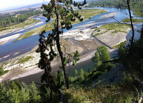
in Prince William Sound, Alaska, on June 5, 2012. (NOAA)
Node Weight: 
4

With Skiff Found off Maui, NOAA and Partners Confirm Hawaii's Latest Reports of Japan Tsunami Marine Debris

Short title: 
With Skiff Found off Maui, NOAA and Partners Confirm Hawaii's Latest Reports of Japan Tsunami Marine Debris

OCT. 6, 2012 — On the heels of Hawaii's first confirmed report of Japan tsunami debris, NOAA and our partners are already examining the second confirmed item: a barnacled skiff which a fisherman found off the Hawaii coast—and which he wants to keep. Using the skiff's registration number, NOAA worked through the Japan Consulate in Hawaii to track down its owner, who expressed no interest in having it returned or in whom took possession of it. The Zephyr, a longline fishing vessel, discovered the 20-by-6-foot skiff approximately 700 nautical miles northeast of Maui and reported it to the U.S. Coast Guard on September 29. After cleaning the aquatic species from its hull, the crew took it aboard and arrived with it in Honolulu Harbor the morning of October 5.

"We appreciate that this fisherman reached out to us and our partners at the Coast Guard and State of Hawaii to alert us of the skiff and determine appropriate measures to take," said Carey Morishige, NOAA's Marine Debris Program Pacific Islands regional coordinator. "Boaters are our eyes on the water and we need their help to be on the lookout for marine debris."

State marine invasive species experts have already examined the skiff for signs of remaining aquatic life, especially those which may be invasive to Hawaii. Although no items connected to the 2011 Japan tsunami have shown above-normal radiation levels, out of an abundance of caution, state Department of Health officials also checked the boat for radiation. Just a few weeks ago, the first confirmed piece of Japan tsunami debris in Hawaii [PDF]—a blue seafood storage bin—showed up off the southeast coast of Oahu. The bin belonged to the Japanese seafood wholesaler Y.K. Suisan, Co., Ltd., whose offices were affected by the 2011 Japan tsunami.

On the morning of September 18, personnel from Makai Ocean Engineering pointed out the buoyant blue container, which is used to transport seafood, near a pier on the southeastern shore of Oahu, and NOAA's Hawaii Undersea Research Laboratory fished the 4-by-4-foot box out of the water. While the lower, submerged portion of the bin was covered in gooseneck barnacles and crabs common in the open sea, a NOAA marine invertebrate scientist joined state aquatic invasive species experts in examining and confirming that none of the organisms were invasive. When the Hawaii Undersea Research Laboratory towed in the bin, they also found five Hawaiian red-footed boobies inside; three of which were dead, though two successfully managed to fly off.

A closeup of the seafood storage bin from Japan found near Oahu and encrusted with marine life.
A close examination of the seafood storage bin from Japan found near Oahu revealed a variety of wildlife both inside (Hawaiian red-footed boobies) and out (gooseneck barnacles and two species of open-water crabs). (Hawaii Undersea Research Laboratory)

Because both the skiff and the seafood bin have unique identifying information, both items have been definitively traced back to Japan and confirmed as lost during the tsunami of March 2011. These items were confirmed with the assistance of the Japan Consulate in Honolulu and Government of Japan. However, the assorted flotsam which Hawaii residents have reported recently is often nearly impossible to connect to the tsunami. It includes everything from unusual light bulbs and a hard hat to plastic containers and pieces of Styrofoam. Marine debris is an everyday problem, and items like these have been known to wash up on Hawaiian shores long before the 2011 tsunami.

While fishermen reportedly saw a floating concrete dock near the Main Hawaiian Islands, it has not been sighted again [PDF] since initial reports on September 19. In the meantime, NOAA has coordinated with the U.S. Coast Guard, State of Hawaii, and other agencies to prepare for its possible reappearance and support the state in its plan to deal with the dock before it makes landfall. The 30-by-50-foot dock appears similar to one that washed ashore in Oregon last June, which, when it arrived encrusted in sea life, prompted concerns about the possibility of aquatic invasive species from Japan. If this latest dock reappeared and proved to be a match, it would be the second of three docks reported missing from Japan following the March 2011 tsunami. However, despite aerial surveys by the U.S. Coast Guard and Hawaii's Department of Land and Natural Resources to identify the dock's location, no additional sightings have surfaced.

NOAA’s Office of Response and Restoration oceanographers have used our GNOME model to forecast the dock's possible movement using data on currents from the University of Hawaii's Regional Ocean Modeling System (ROMS) and wind forecasts from NOAA's National Weather Service. However, the accuracy of the model’s predictions is unknown due to the lack of observational data on where the dock was traveling over time. In addition, NOAA has prepared two satellite tracking buoys for Hawaii to use in case the dock is relocated. Hawaii's Department of Land and Natural Resources, the state's lead agency for responding to possible Japan tsunami marine debris, is asking that boaters, fishers, and pilots keep an eye out for debris. If sighted, the agency says to call in reports immediately to 1.808.587.0400.

The NOAA Marine Debris Program also is gathering sightings of potential Japan tsunami marine debris at DisasterDebris@noaa.gov. Find out what you should do if you think you have found marine debris from the Japan tsunami. Keep up with NOAA's latest efforts surrounding the issue of Japan tsunami marine debris at http://marinedebris.noaa.gov/tsunamidebris/.

The 20-by-6-foot skiff covered in barnacles is towed behind a fishing vessel.
After finding the 20-by-6-foot skiff covered in barnacles floating northeast of Maui, the crew of the F/V Zephyr towed it in and cleaned it up. This skiff is Hawaii’s second confirmed piece of marine debris connected to the 2011 Japan tsunami. (Peter Grillo, F/V Zephyr)
Towing in the 4-by-4-foot plastic seafood storage bin off Oahu.
NOAA's Hawaii Undersea Research Laboratory tows in the 4-by-4-foot plastic bin which was the first confirmed item of Japan tsunami marine debris in Hawaii. It was spotted at sea off the eastern coast of Oahu, Hawaii, on September 18, 2012. (Hawaii Undersea Research Laboratory)
Node Weight: 
7

A Superfund Success for Marsh Restoration near Galveston Bay, Texas

Short title: 
A Superfund Success for Marsh Restoration near Galveston Bay, Texas

OCT. 1, 2012 — In many ways, the Superfund site at the former home of the Malone Service Company in Texas City, Texas, is just like the hundreds of other waste sites scattered across this country.

It is located on what was once undeveloped land, bordered by productive wetland and marsh, a lake, and Galveston Bay, the nation's seventh largest estuary.

The stream of pollution began back in the 1960s when the company set up shop as an industrial waste disposal facility. This was before a veritable flood of federal and state laws (like the Clean Water Act and the Comprehensive Environmental Response, Compensation and Liability Act, a.k.a., CERCLA or the Superfund Law) began to regulate or prohibit dumping hazardous waste into the environment. (But mismanagement of the waste continued even after CERCLA was passed in 1980.)

The list of those potentially responsible for the pollution is long and ranges from large businesses to government entities to small private companies.

The Malone Service Company Superfund site map.
The Malone Service Company Superfund site and surrounding area near Texas City, Texas. Click to enlarge.

Here too, the contamination was varied (e.g., heavy metals, potentially toxic oil residues) and comprehensive, affecting the soil, water, and underwater sediments [PDF]. And, of course, it injured a number of natural resources, including birds, aquatic life, and their habitats.

What sets this case apart from most is that those potentially responsible for the pollution and the state and federal governments were able to work together to reach an agreement to clean up and restore the affected natural resources—no easy feat considering the long and complicated history.

Office of Response and Restoration scientist Jessica White entered the scene in 2004, working as a scientist to investigate how bad the contamination was and which natural resources were impacted. She has continued working on the Malone site as it makes its way from remediation toward recovery and long-term monitoring.

By participating in the Superfund process, she and the rest of the trustees (charged with protecting public natural resources) were able to get the information needed to conduct the damage assessment of those resources without having to perform independent studies. This saved both time and money.

Fortunately, this group was also able to contribute to this restoration process everything they know about these animals, plants, and habitats, ensuring that the environmental impacts were adequately addressed and that further impacts from cleanup would be minimized. Collaborating with the U.S. Environmental Protection Agency (EPA), which leads Superfund cleanups, made this a win-win situation.

Our damage assessment showed the natural resources living in coastal prairie habitat, freshwater habitat, and saltwater marsh habitat suffered significantly. In particular, birds and invertebrates really felt the effects of the contaminated water and sediments.

Campbell's Bayou cemetery and restoration workers.
The cemetery for the 19th century settlement known as Campbell's Bayou, a state historic site, is actually located on the Malone waste site. Restoration experts had to work around the cemetery. (NOAA/Jessica White)

(And in a highly unusual twist, the team had to work around a cemetery for the old settlement of Campbell's Bayou, which is a state historic site.)

So, how much would it cost to restore, replace, or acquire the equivalent of these injured habitats? After adding in the cost of a few other things, such as monitoring the environment's future health, the trustees and those paying finally settled on $3 million in damages.

Still ahead, however, is identifying the most appropriate restoration projects to make up for these losses. Likely restoration will take the form of preserving marsh habitat or acquiring marsh and oak motte (grove) habitat. It could even mean constructing new marsh nearby.

On top of the $3 million for restoration is another $56.4 million to clean up the remaining pollution. This remediation, which the EPA will oversee, will be the first step toward primary on-site restoration of the Malone Superfund site.

Unlike many other waste sites which sit lingering across the country, the trustees, EPA, and potentially responsible parties have overcome many obstacles to remove this source of contamination from the Texas City community and restore the habitat for the natural resources depending on it.

Migrating birds, drawn to the coast, will no longer die in the open oil pits, whose watery surfaces lured them in. In the future, this land may offer instead a safe source of freshwater for birds and enjoyment for the bird watchers who follow them.

Oil pit at Malone Service Company waste site.
Oil pits dominate the landscape at the Superfund site where the Malone Service Company processed waste chemicals and oils from 1964 to 1996. (NOAA)
Node Weight: 
5

Help Avert Disaster with CAMEO Chemicals for Your Smartphone

Short title: 
Help Avert Disaster with CAMEO Chemicals for Your Smartphone

SEPT. 25, 2012 — Picture this: a call comes in to a fire station—three train cars have derailed.

As the responding firefighters race to the scene, news comes over the radio that several chemical containers on board were damaged, some may be leaking their hazardous contents, and somebody mentioned smelling smoke.

What should the approaching firefighters do?

Fortunately, first responders now have a new place to find the critical information they need in this situation: their smartphone.

NOAA's Office of Response and Restoration recently launched a mobile website version of CAMEO Chemicals, an essential resource for emergency responders.

Because no one could possibly memorize response recommendations for the thousands of hazardous materials shipped across the U.S. or stored in facilities, we developed CAMEO Chemicals as a searchable chemical response encyclopedia.

Screen shot of CAMEO Chemicals mobile website for the chemical toluene.
A view of the mobile CAMEO Chemicals site for the chemical toluene. (NOAA)

This kind of quick access to information about a chemical is critical. A hazardous material incident can escalate quickly and, in the case of some toxic gas clouds, can cause harm and then dissipate within minutes.

Because of these factors, responders need to be able to find specific information, for example, whether the spilled chemical will react violently with water. Will it spontaneously combust? What happens if it's exposed to fire? And they need to know all of this at a moment's notice.

When time is of the essence, having multiple avenues to this key information can be invaluable. Most hazmat fire trucks carry print copies of response guides, such as the Emergency Response Guidebook, and many also roll with a laptop onboard with special software installed. One of those software products is our suite of programs called CAMEO, which includes CAMEO Chemicals and also the mapping application MARPLOT.

CAMEO Chemicals combines a number of data sources, including the Emergency Response Guidebook. The U.S. Environmental Protection Agency and NOAA have been partnering to keep this tool updated since the first version was installed on a Macintosh Plus computer and bolted to a table on a hazmat fire truck back in the 1980s.

(Actually, our office first created a Microsoft DOS version—but then switched to Macintosh, because Apple's then-new concept of using a mouse to navigate a computer seemed like the perfect, easy-to-use solution for firefighters.)

The cutting-edge Macintosh SE computer.
The cutting-edge Macintosh SE—on a fire truck near you! This successor to the Macintosh Plus loyally served CAMEO programmers for years. (NOAA)

Having CAMEO Chemicals installed on a laptop computer can be crucial if, say, you are responding to an area hit by a tornado and there is no internet connection or cellular service available.

But getting software installed by information technology staff can be difficult for some organizations, as is keeping it up-to-date. As a result, we released an online version of CAMEO Chemicals in 2007. Having it available on the web means anyone—such as a police officer—who is suddenly responding to a chemical accident can get this information on the fly.

This year, with the rising ubiquity of smartphones, the time seemed right to release a version of the website customized for mobile devices. Now, as of August 2012, a first responder with nothing more than a phone (with access to the Internet) can navigate thousands of chemicals with just the swipe of a finger.

A student from the nearby University of Washington joined our team in Seattle, Wash., and developed this mobile version of the CAMEO Chemicals website over the course of the summer. Thanks to him (and the EPA and NOAA, of course), emergency responders now have one more tool to add to their toolbox.

Explosions and fire at the Barton Solvents facility in Valley Center, Kansas.
Having instant and reliable access to chemical information is key for responders dealing with accidents such as the 2007 explosions and fire at the Barton Solvents facility in Valley Center, Kansas, north of Wichita. This incident led to the evacuation of thousands of residents and resulted in projectile damage offsite, as well as extensive damage to the facility. (U.S. Chemical Safety Board)
Node Weight: 
5

Weeks Later, Responders Still Dealing with Pollution Left in Hurricane Isaac's Wake

Short title: 
Weeks Later, Responders Still Dealing with Pollution Left in Hurricane Isaac's Wake

SEPT. 18, 2012 — Even though Hurricane Isaac blew off the weather radar several weeks ago, the pollution and destruction it left behind in the Gulf of Mexico still remain.

After the hurricane's initial landfall the week of Aug. 28, the U.S. Coast Guard received reports of 158 oil spills and 171 hazardous material targets in the affected areas in Louisiana. Some two weeks later, the numbers are down to 13 open oil discharges and 57 hazardous material targets remaining.

At this time, NOAA's Office of Response and Restoration has five support personnel, consisting of Scientific Support Coordinators and information management specialists, on scene in the New Orleans command post assisting response operations for these cleanups. The incidents ranged from very small (several gallons) to medium (60,000 gallons) sized releases of oil and a wide variety of chemicals.

Sample ESI map, showing part of the Point Reyes National Seashore.
Map of locations of oil and hazardous material spills in Louisiana resulting from Hurricane Isaac, as of Sept. 17, 2012. (NOAA)
NOAA's Lieutenant (junior grade) Kyle Jellison describing the location of oil spill sites to the U.S. Coast Guard Situation Unit inside the Hurricane Isaac command post in New Orleans, La.
NOAA's Lieutenant (junior grade) Kyle Jellison describing the location of oil spill sites to the U.S. Coast Guard Situation Unit inside the Hurricane Isaac command post in New Orleans, La. (NOAA/Ed Levine)

NOAA has been involved in assessing shorelines possibly affected by these spills, conducting aerial surveys of coastal waters, making cleanup recommendations, and performing final assessments of oiled areas that have been cleaned up. In addition, our experts have been coordinating the federal and state agencies involved, mapping data, and managing response information in databases.

This work is in support of the unified command, which is made up of the U.S. Coast Guard and Louisiana Oil Spill Coordinator's Office, along with several oil and chemical facilities identified as the originators of materials spilled during the hurricane.

Additionally, OR&R is collaborating with the U.S. Fish and Wildlife Service, NOAA National Marine Fisheries Service, NOAA National Weather Service, Louisiana Office of Historic Preservation, and the Louisiana Department of Wildlife and Fisheries' Scenic Rivers program to address impacts to natural resources and to determine when cleanups are complete. NOAA anticipates being on scene another week.

Three cleaned brown pelicans prior to being released.
Three cleaned brown pelicans prior to being released at the wildlife rehabilitation center. (NOAA/Ed Levine)
Node Weight: 
2

Making the Best of a Catch in Whale-Friendly Lobster Fishing

Short title: 
Making the Best of a Catch in Whale-Friendly Lobster Fishing

SEPT. 12, 2012 — Derelict fishing gear is a prevalent type of marine debris throughout the oceans, and like other forms of marine debris, it is a complicated issue without a clear solution. In New Hampshire and throughout New England states, regulations designed to protect important marine species and the personal property of lobstermen have unintentionally led to a significant marine debris issue.

To understand the issue, it's important to understand how the lobster fishery works in New England. Lobsters are caught using metal or wooden lobster "pots," which can be deployed in a number of configurations based off of the following general diagram. For many more configurations in addition to the one below, check out the Maine Lobstermen's Association 2012 Gear Report [PDF].

The diagram highlights two important gear modifications designed to prevent harmful interactions between local marine mammals and lobster gear that have also contributed to the marine debris issue: the weak link and sink line. The weak link is designed to allow the buoy to easily disconnect from the sink line if a marine mammal comes in contact with it. However, the buoy can also easily detach if a boat accidentally hits it, which can ultimately lead to lost gear.

The basic configuration of lobster trap deployment.

Up until 2009, the loss of traps through these accidental encounters with boats was mitigated through float lines; if the buoy was disconnected, the line attached to all of the lobster pots would at least still float at the surface. However, these float lines also posed a threat to marine mammals, which could become entangled. Regulations now require that sink lines are used on lobster pots. While the weak link and the sink line are important for marine mammals, these modifications can cause lobster pots to become marine debris.

Ghostfishing

Once lost, the derelict lobster pots can negatively impact the marine environment and economy. Lost pots can continue to fish for target and non-target species (known as "ghostfishing"), many times capturing and killing either protected or commercially important organisms. In addition, strong water currents can drag pots along the bottom, scouring and damaging sensitive marine habitats. Strong storms can even move lobster pots out of the water, impacting coastal habitats as well. The lost pots can also hinder the lobster fishery, by taking up prime real estate on the seafloor that could otherwise be used for fished pots.

While the derelict fishing gear issue poses a great problem, regulations in coastal New England states designed to protect the property of lobstermen unintentionally make cleanup of derelict pots difficult. In states such as Massachusetts, New Hampshire, and Maine (among others), removing or even touching fishing gear belonging to someone else is prohibited, even if the gear is unfishable. These laws were established when lobster pots were frequently being stolen to make lobster pot coffee tables. These regulations are important and remain to protect the catch and property of lobstermen; however, they hinder gear cleanups as a local regulatory official must be present at the cleanup to determine if gear can be removed.

Fishing for Solutions

While the ultimate solution lies in finding a way to prevent gear from being lost in the first place, the Fishing for Energy program provides a solution to cleaning up the gear currently present. In addition to the general program that provides bins for derelict gear disposal, each year a Fishing for Energy grant program offers competitive funding for groups to conduct assessments and removal of derelict fishing gear throughout the United States. Successful projects are required to engage fishermen and, in states where necessary, state marine regulatory officials. Engaging fishermen helps to increase awareness of the derelict fishing gear issue throughout the fishing community, and involving local regulatory officials alleviates legal hindrances to gear removal. As with the bin program, all collected gear is recycled or burned as a source of renewable energy with the help of Schnitzer Steel or Covanta Energy.

Derelict lobster traps collected from White Island in the Isles of Shoals.
Derelict lobster traps collected from White Island in the Isles of Shoals, Gulf of Maine. (Gabriela Bradt, UNH Sea Grant and Blue Ocean Society for Marine Conservation)
Node Weight: 
3

Healthy Habitat, Healthy Economy: Restoration Creates American Jobs

Short title: 
Healthy Habitat, Healthy Economy: Restoration Creates American Jobs

SEPT. 10, 2012 — For many former industrial sites around the country, the same heavy machines that injured habitat could also be used to reverse environmental damage, thus creating jobs both now and in the future. A recent study by the nonprofit Ecotrust [PDF, 1.6 MB] found that $411 million invested in restoration work in Oregon from 2001-2010 generated as much as $977 million in economic output. And labor-intensive restoration—like building oyster reefs in coastal Alabama—creates more than 30 jobs per million dollars invested. (That's more than twice as many jobs as the oil and gas and road construction industries combined.) NOAA's Restoration Center has even more studies like this from around the nation documenting the benefits of the "restoration economy."

Re-creating coastal habitats that were lost due to human impact doesn't just benefit wildlife. It also supports fisheries, tourism, and coastal resiliency for years down the road. Restoration projects create jobs for construction workers, landscapers, heavy equipment operators, and technical experts such as engineers and wildlife biologists. These same restoration projects also create demand for local businesses, such as plant nurseries and rock quarries. The Office of Response and Restoration is just one piston of the NOAA engine for coastal restoration. Restoration projects being led by NOAA are occurring all across this county. Visit NOAA's Restoration Atlas to locate one near you. Watch this video to learn even more about how the restoration economy is helping to keep people in jobs:

Heavy equipment removes dredge from a marsh restoration site.
Heavy equipment removes dredge and landfill material from this site of marsh restoration in Lincoln Park, N.J. According to a recent study, NOAA has created 33 jobs for every $1 million spent to restore habitat through "labor intensive" projects.
Node Weight: 
3

NOAA's Office of Response and Restoration Responds to Hurricane Isaac in the Gulf

Short title: 
NOAA's Office of Response and Restoration Responds to Hurricane Isaac in the Gulf

SEPT. 6, 2012 — Office of Response and Restoration staff continues to support the U.S. Coast Guard's assessment and response efforts following the landfall of Hurricane Isaac last week. Our office has two Scientific Support Coordinators and two information management specialists on scene in Louisiana. Additional support is being provided remotely for ERMA® (an online mapping tool for visualizing key environmental response data) and for response management. The Gulf of Mexico Regional ERMA site is being used as the U.S. Coast Guard Common Operational Picture and is providing operations, environmental, and situation unit support for the federal response efforts. Our information management and ERMA team members are coordinating with the Coast Guard, U.S. Environmental Protection Agency, and state and local partners to provide real-time situational awareness for local and remote agency personnel.

The primary focus is on oil and chemical pollution from sunken vessels, facility releases, toppled tanks and rail cars, and pipeline and rig spills. Pollution is to be expected following major storms like Isaac when flood waters carry all sorts of household and industrial debris. So far, Coast Guard and Louisiana Department of Environmental Quality assessment teams have investigated about 90 separate reports of pollution throughout the impacted areas. Facility owners are taking steps to clean up the majority of these incidents. Six sites require further assessment, and environmental response crews are taking steps to clean up or contain any oil releases.

The OR&R team is also tracking marine debris and evaluating the effect of the passing hurricane on shorelines affected by the Deepwater Horizon/BP oil spill. Shoreline Cleanup Assessment Technique (SCAT) teams are beginning operations along the Gulf Coast looking for new spills but also focusing on tarballs and oily residue discovered in the area oiled by the Deepwater Horizon/BP spill in 2010. Samples of tarballs are being collected and will be analyzed to determine the source.

Flooded Mississippi River after Hurricane Isaac.
Flooding on the Mississippi River, just west of New Orleans, La., in the aftermath of Hurricane Isaac. (NOAA)
Node Weight: 
3

Fishing for Energy: Where Old Fishing Gear Goes to Retire

Short title: 
Fishing for Energy: Where Old Fishing Gear Goes to Retire

SEPT. 5, 2012 — Although consumer debris is the most commonly collected item during beach cleanups, below the water lies another form of debris that is equally prevalent and harmful: derelict fishing gear. Defined as gear that has been lost or abandoned in the marine environment, derelict fishing gear poses a huge threat to marine organisms and the environment through impacts such as entanglements and ghost fishing. It consists of any items used for recreational or commercial fishing activities, such as nets, pots, ropes, and fishing line.

When the NOAA Marine Debris Program was established through the Marine Debris Research, Prevention, and Reduction Act of 2006, the program was charged with the "development of effective non-regulatory measures and incentives to cooperatively reduce the volume of lost and discarded fishing gear and to aid in its recovery."

In essence, we needed to develop a program to keep fishing gear from becoming marine debris. Enter the Fishing for Energy program. Fishing for Energy is a partnership between Covanta Energy, the National Fish and Wildlife Foundation, the NOAA Marine Debris Program (a part of the Office of Response and Restoration), and Schnitzer Steel, designed to provide a cost free disposal solution for derelict or otherwise unusable fishing gear to commercial fishermen across the nation. The program gives fishermen a place to dispose of derelict gear they come across while on the water and eases the financial burden associated with the disposal of unusable fishing gear in landfills. By placing bins at busy fishing ports, the program significantly increases the likelihood that derelict gear does not become marine debris.

How does Fishing for Energy work? The partnership strategically places dumpsters at busy fishing ports around the country, where commercial fishermen can easily dispose of old, unusable fishing gear. Full dumpsters of collected gear are then transported to local Schnitzer Steel facility, where metal gear is recycled and nets and pots are sheared for easier disposal. From there, the gear is brought to the local Covanta Energy facility where gear, such as ropes and nets, are burned as a source of renewable energy to power local communities.

Today, Fishing for Energy is represented in 9 states and 31 ports across the country. Since its establishment in 2008, about 750 tons of gear (nearly 1.5 million pounds!) have been prevented from becoming marine debris. Learn more about the issue of derelict fishing gear and the process of turning marine debris into energy through the NOAA Marine Debris Program's Fishing for Energy partnership.

Disposing of derelict fishing gear in a Fishing for Energy bin.
Disposing of derelict fishing gear in a Fishing for Energy bin. Collected gear is burned to create energy at Covanta Energy facilities or recycled through Schnitzer Steel. (National Fish and Wildlife Foundation)
A derelict stone crab pot rests on the bottom of the ocean.
A derelict stone crab pot rests on the bottom of the ocean in waters off the Florida coast. (NOAA)
Node Weight: 
9

Tropical Storm Isaac Past, Responders Continue Removing Grounded Ship from Corals near Puerto Rico

Short title: 
Tropical Storm Isaac Past, Responders Continue Removing Grounded Ship from Corals near Puerto Rico

AUG. 28, 2012 — With the passage of the Tropical Storm formerly known as Hurricane Isaac, salvage crews and coral ecologists are once again back on Mona Island, Puerto Rico, working to remove the grounded freighter M/V Jireh while also protecting the island's corals. In previous ship salvage cases involving coral habitats, biologists have observed considerable coral damage from not only the physical placement of anchors, cables, and support vessels, but also continued shifting and grinding from the grounded vessel.

As a result, crews are working carefully to keep that from happening here. In such a long and complicated salvage project, it is impossible to prevent all impacts, but crews are continuing to remove and reattach corals at risk from the grounded ship. Nearly 1,000 corals have been moved already. These transplanted corals are expected to have a high survival rate and reduce the overall impacts from the vessel removal operation. A NOAA-authorized biologist is on site during all coral relocation operations to make sure corals are properly handled and reattached to reefs.

Before responders attempt to refloat the vessel, qualified divers will evaluate the corals in the area and determine an exit path for the damaged ship that will have the least impact to the surrounding coral habitat. This may or may not turn out to be the same path the ship took when it entered the reef. Depending on conditions after the vessel's removal, the coral colonies may be relocated back to their original place on the reef. The U.S. Coast Guard and the rest of the response crew have been working carefully to cut up portions of the ship, in order to lighten the vessel enough to refloat and remove it from the reef. Once disassembled, the removed portions of the ship are loaded onto a barge and taken to Puerto Rico for recycling. Additionally, since the grounding on June 21, crews already have removed 600 tons of oiled cargo and more than 5,000 gallons of oil-water mixture.

Diagram of Jireh removal and disposal process.
Jireh removal and disposal process. (Jireh Grounding Unified Command) Click to enlarge.

In the diagram at right, you can see their plan for removing and disposing of this damaged vessel. Once the ship is refloated, the plan is to scuttle (purposefully sink) the wreck 12 miles away from Mona Island. After it is sunk, the wreckage is not expected to pose any additional risk to corals or other marine life. The difference with this shipwreck is the location.

"Intertidal wrecks are unstable and scour the reefs as they degrade and fall apart, while a wreck far out at sea becomes a stable deep-water habitat over time," said Doug Helton, Incident Operations Coordinator for the Office of Response and Restoration.

The Coast Guard reports that removing the Jireh from Mona Island is the best solution to protect the sensitive environment and coral reefs surrounding this highly valuable natural reserve. Once this threat is permanently removed, NOAA divers will conduct an assessment of the grounding area and continue to work with local environmental agencies to ensure its full recovery.

Response barges are anchored near the grounded M/V Jireh.
August 20, 2012 -- Response barges are anchored near the M/V Jireh (foreground), which grounded on coral reefs in June. (U.S. Coast Guard/Jaclyn Young)
Sections of the Jireh's hull are removed to lighten the vessel.
Aug. 18, 2012 -- Sections of the Jireh's hull are removed to lighten the vessel before it is attempted to be refloated and eventually sunk in deep water. (U.S. Coast Guard/Jaclyn Young)
Node Weight: 
3

The Toxicity of Oil: What's the Big Deal?

Short title: 
The Toxicity of Oil: What's the Big Deal?

Toxic Effects

We call something toxic if it harms living things. The amount of harm caused depends on how an organism is exposed and to how much oil. For example, crude oil is considered toxic and causes two main kinds of injury: physical and biochemical.

The physical effects of freshly spilled crude oil are all too obvious. You've likely seen the disturbing images of birds and other animals coated in crude oil, struggling to survive. When oil washes ashore, it can completely cover and smother the plants and animals living there.

Crude oil not only destroys the insulating properties of animal fur and bird feathers, which can lead to hypothermia, but it also impairs animals' abilities to fly and swim, sometimes causing oiled animals to drown.

During the months after the 1989 Exxon Valdez oil spill, researchers collected about 30,000 dead birds—ranging over 90 different species—from the oiled areas, and they estimated that perhaps ten times as many birds died.

Spilled oil also can harm life because its chemical constituents are poisonous. As we previously learned, petroleum-derived oil is a complex mixture of thousands of chemical compounds. Given oil's chemical complexity, we need to consider how these different components—and their very different effects on living things—cause harm.

Breaking It Down

Let's look at two important components of crude oil: volatile organic compounds (VOCs) and polycyclic aromatic hydrocarbons (PAHs). In terms of how long they remain in the environment, they represent two ends of a spectrum.

All crude oil contains VOCs, which readily evaporate into the air, giving crude oil a distinctive odor. Some VOCs are acutely toxic when inhaled, in addition to being potentially cancer-causing. At the site of a fresh oil spill, these VOCs can threaten nearby residents, responders working on the spill, air-breathing marine mammals, and sea turtles at the water surface. However, VOCs are generally a response concern only right after oil is spilled, because oil floating on the sea surface quickly loses its VOCs.

In contrast, PAHs can persist in the environment for many years, in some cases continuing to harm organisms long after the oil first spills. How PAHs in oil do that is an active area of research.

For example, our colleagues at NOAA's Auke Bay Laboratory near Juneau, Alaska, investigated the possible biological effects of oil that spilled from the Exxon Valdez in 1989 but still remains at very low concentrations in weathered oil in beach sediments at locations scattered around Prince William Sound.

The Auke Bay Lab researchers conducted a series of studies that continued for more than a decade. They found that even though the levels of PAHs leaching from weathered oil buried in beach sediments were very low, the PAHs still caused negative effects to incubating herring and salmon eggs. The good news from these studies is that over the years, the concentration of PAHs has declined in the Sound's beach sediments, to the point that those particular toxic effects on fish eggs have diminished as well. However, at a few sites in the Sound, sea otters are eating clams that may continue to be contaminated by leaching PAHs in buried oil.

The Northwest Fisheries Science Center, another NOAA research laboratory in Seattle, Wash., has studied the chemical physiology of how PAHs harm developing fish. The researchers found that some PAHs in oil inhibit proper heart development in fish embryos, which can either kill the fish outright or make them more susceptible to predation and disease.

With so many varying factors coming into play, predicting the impacts of an oil spill can be quite challenging. It’s important to know the specific chemical makeup of an oil (and how that makeup changes over time as the oil weathers). This information will give us clues about how that oil will interact with organisms and the environment and, hopefully, will help us figure out how to keep those impacts low.

NOAA veterinarian holding an oiled sea turtle.
Dr. Brian Stacy, NOAA veterinarian, prepares to clean an oiled Kemp's Ridley turtle during the response to the 2010 Deepwater Horizon/BP oil spill. Veterinarians and scientists from NOAA, the Florida Fish and Wildlife Commission, and other partners worked under the Unified Command to capture heavily-oiled young turtles 20 to 40 miles offshore as part of animal rescue and rehabilitation efforts. (NOAA and Georgia Department of Natural Resources.)
Heavy residual oiling remains in sediments in Prince William Sound.
Years after the Exxon Valdez oil spill, heavy residual oiling remains in sediments of Smith Island in Prince William Sound, Alaska, June 2011. (David Janka, R/V Auklet, NOAA)
Node Weight: 
4

Small Japanese Boat Found near Vancouver Island, Canada, Even as Summer Currents Hold Marine Debris at Bay for now

Short title: 
Small Japanese Boat Found near Vancouver Island, Canada, Even as Summer Currents Hold Marine Debris at Bay for now

A Summer Decrease in Debris

While this brings the total number of confirmed tsunami debris sightings to 11, summer weather patterns have created a lull in debris turning up on nearby Washington's coast. This has the state Department of Ecology taking back some of the additional trash receptacles they provided near public access points earlier this summer. Recent decreases in reported marine debris in these areas, along with reports of someone using them to dump household waste, led to the removal.

"We want to ensure we are stretching our dollars as far as we can," said Peter Lyon, a Washington Department of Ecology regional manager. "In June, when the boxes were placed along beaches, a southwest wind pattern directed more debris ashore in those areas than we are seeing now. When weather patterns shift again in the fall, we are likely to see higher amounts of debris again. So we want to conserve our resources in case that happens."

The Washington Department of Ecology states that the trash bins can be easily and quickly redeployed within about 24 hours to accommodate possible increases in marine debris in the future. The funding to stock the bins and litter bags came from Department of Ecology’s litter account, setting aside $100,000 to deal with marine debris. These supplies help support community and volunteer efforts to collect and dispose of debris on Washington beaches.

Where Is the Debris Now?

NOAA's Office of Response and Restoration has oceanographers Glen Watabayashi and Amy MacFadyen using our GNOME model to give us an understanding of where debris from the tsunami may be located today. GNOME is a software modeling tool used to predict the possible route pollutants might follow in a body of water, and we use it most frequently during an oil spill.

Our oceanographers are incorporating into this model how the winds and ocean currents since the tsunami may have moved items through the Pacific Ocean. However, rather than forecasting when debris will reach U.S. shores in the future, this model uses data from past winds and currents to show possible patterns of where debris may be concentrated right now.

"For me the story is not what's been found but what hasn't been found," said NOAA oceanographer Glen Watabayashi. "With all the summer vessel traffic along the West Coast and out in the North Pacific, there have been no reports of any large concentrations of debris."

Learn more at http://marinedebris.noaa.gov/tsunamidebris/.

Small boat on rocky shoreline.
The small boat which washed up on remote Spring Island, British Columbia, Canada, was positively identified as a vessel lost during the 2011 Japan tsunami. Credit: Kevin Head.
Node Weight: 
4

Chemistry of an Oil Spill

Short title: 
Chemistry of an Oil Spill

This is part of an ongoing exploration of society's relationship with oil and the large part oil plays in all of our lives. AUG. 21, 2012 — Oil. For something that we all depend on every day, how much do we really understand about what it is and why it's so useful? Oil comes from beneath the ground. It is made of dead animal and plant matter, buried deep under layers of sedimentary rock. Pressure and heat cause oil deposits to form over long periods of time. But what is oil at its most basic?

Oil is a complex mixture of molecular compounds. A molecule is the smallest unit of a substance that retains the substance's characteristics. Molecules, in turn, are composed of atoms. There are only 90 naturally occurring types of atoms on earth; these form the basis of the innumerable types of molecules found in nature. Crude oils, while mixtures of thousands of types of molecular compounds, are predominantly composed of only two types of atoms: hydrogen (H) and carbon (C). Molecular compounds composed exclusively of these two elements are called hydrocarbons. Petroleum hydrocarbons are predominantly one of two types, aromatics or alkanes. Aromatics, which are based on a 6-carbon ring, tend to be the molecular compounds in oil that are the most toxic to marine life.

A notable case is polycyclic aromatic hydrocarbons (PAHs), which have multiple carbon rings and can also be quite persistent in the environment. Alkanes, on the other hand, tend to be less toxic and are much more readily biodegraded naturally; most can be ingested as food by some microorganisms. For example, the oil spilled from the 2010 Deepwater Horizon/BP well blow-out was relatively high in alkanes and relatively low in PAHs. But, like all crude oils, it contained benzene, toluene, and xylene, which belong to the single-ring aromatic group. Benzene is very toxic and known to cause cancer but is not as persistent as PAHs.

Refining crude oil to produce fuel oils like gasoline and diesel does not significantly alter the molecular structure of the oil's components. So fuel oils usually contain the same types of molecular compounds that are found in their parent crude oils. Different chemical compounds can be extracted from crude oil and then recombined or altered to make what are called petrochemicals. Petrochemicals are used to make a vast array of products, including acetic acid, ammonia, polyvinyl chloride, polyethylene, lubricants, adhesives, agrochemicals, fragrances, food additives, packaging, paint, and pharmaceutical products. And that's just the start!

Emulsified oil from the 2010 Deepwater Horizon/BP spill pooled on marsh vegetation.
Emulsified oil from the 2010 Deepwater Horizon/BP spill remains on, and pooled below, vegetation in Pass a Loutre, La., following a previous week's storm. Image shot on May 22, 2010. (NOAA)

NOAA's Office of Response and Restoration is the primary science adviser to the U.S. Coast Guard during a major oil spill. Knowledge of the chemical make-up of the particular oil, whether it is a crude oil or refined fuel oil, is critical in making response decisions when there is spill. Among the scientists that work in OR&R's Emergency Response Division are chemists that are experts in this field. Crude oil is predominantly a mixture of hydrocarbons, but every crude oil is a unique mixture of molecular compounds. There are thousands of named crude oils in use around the world. Our chemists make recommendations by determining the source of the spill and the optimal cleanup methods and safety issues, based on the unique properties of the oil released. Next up, we'll delve into the toxicity of oil and the harm it can cause when accidentally released into the marine environment.

Oil in marsh vegetation during the 2010 Deepwater Horizon/BP oil spill.
Oil in marsh vegetation during the 2010 Deepwater Horizon/BP oil spill. (NOAA)
Diagram of the molecular structure of benzene.
A diagram of the molecular structure of benzene, an aromatic hydrocarbon and component of oil.
Node Weight: 
3

With Restoration, Will Willamette River Lampreys Rebound for Northwest Tribes?

Short title: 
With Restoration, Will Willamette River Lampreys Rebound for Northwest Tribes?

AUG. 9, 2012 — It's mid-summer, and something amazing is happening at Willamette Falls, a pounding cascade of water about 30 minutes from downtown Portland, Oregon. People are balancing on mossy, wet boulders tucked among the falls, reaching into its waters to harvest Pacific lamprey by hand. After pouring over the falls, the Willamette River rolls on for nearly 30 miles before joining the Columbia River. Prior to the construction of dams throughout the Columbia River basin, which includes the Willamette River and its tributaries, native Americans harvested lampreys in many other locations in much the same way they do now at Willamette Falls: by braving the cascading water and slippery rocks to grab wriggling lamprey by hand or with dip nets.

Northwest tribes have relied on the lamprey for food, medicinal, and ceremonial purposes for generations, since long before the first European explorers and fur traders became aware of these falls. But virtually all of the tribes' historic collection spots are gone now, either because they are submerged under dam-impounded waters or because lampreys are absent, their upstream journey blocked by dams. Willamette Falls is the last place in the Columbia basin where tribes can collect lampreys as their ancestors did. So it's not surprising that the tribes are concerned about the Willamette River lamprey and the rest of the Columbia basin lamprey population. In fact, lamprey numbers have declined steadily since at least the 1960s.

According to a 2008 U.S. Fish and Wildlife Service fact sheet [PDF], likely threats to lampreys include habitat loss associated with passage barriers, dredging, and stream and floodplain degradation; river flow alterations; predation by non-native species; poor water quality; changing ocean conditions; and exposure to toxic substances. Willamette River lamprey may be particularly vulnerable when it comes to toxic substances. Paddle the river as it flows north from the falls and you will eventually pass by downtown Portland. It is about here that you enter the Portland Harbor Superfund site, an 11-mile stretch of river with numerous patches of contaminated sediments from more than 100 years of industrial and urban uses.

Juvenile lampreys, called ammocoetes, must pass through this portion of river on their seaward migration, just as adult lampreys do as they return upriver to spawn. But it is the ammocoetes that are most likely to be at risk from pollutants buried in the riverbed. Lampreys are an anadromous species, which means they spawn in freshwater, spend their adulthood in the ocean, and return to freshwater to reproduce. In this respect they are similar to salmon, but lamprey life cycles are more complex. After hatching from their eggs, ammocoetes drift downstream to areas with slow-moving water and silty, sandy sediments. Here they burrow into the sediments and filter-feed for up to seven years before emerging to continue their journey to the sea. It is during this time that they may be particularly vulnerable as they eat contaminated foods and are directly exposed to pollutants for long periods. Ammocoetes are known to use the stretch of the Willamette River encompassed by the Superfund site, and lamprey tissue samples collected from within the site show higher levels of contaminants than those collected from cleaner sediments upstream of Portland Harbor.

It is not clear how ammocoetes in Portland Harbor are affected by contamination, but at least one analysis suggests exposure to contaminated sediment from Portland Harbor may adversely affect their behavior. So what is being done? The Environmental Protection Agency (EPA) has been working with its partners and a group of companies called the Lower Willamette Group to assess risks to human health and the environment and to determine how best to clean up the river. EPA's efforts are ultimately aimed at removing the threats posed by contaminated sediments. NOAA is one of eight members on a trustee council that is working to understand how contaminants may have impacted natural resources. The council is also planning habitat restoration projects to make up for those impacts. (The other members of the council include five tribes—Grand Ronde, Siletz, Umatilla, Warm Springs, and Nez Perce—and the state and federal fish and wildlife agencies.)

Tribal member displays cooler with harvest of lamprey.
Michael Wilson, Confederated Tribes of Grand Ronde Tribal member and the Tribe’s Natural Resources Department manager, shows the lamprey that were harvested by NRD staff at Willamette Falls on Friday, July 29, 2011. (Photo courtesy of Rebecca McCoun.)

In addition to the lamprey, the council is planning restoration projects to benefit other types of fish and wildlife, like osprey, bald eagles, mink, and salmon. The council is focusing on these species because evidence suggests they may have been most impacted by contaminants and because they represent species guilds that are important in the lower Willamette River and similar Pacific Northwest ecosystems. This summer, the council wants to hear what the public thinks about restoration in Portland Harbor. A plan that lays out restoration options to benefit lampreys and other species that use the lower Willamette River, Multnomah Channel, and parts of the Columbia River close to the Superfund site has just been released. The council wants to hear from tribal members; people who fish on the river; folks who like to bike, jog, or picnic along the river; and others who care about the health of fish, wildlife and other natural resources in the Superfund site.

The plan includes a list of 44 potential restoration projects, including activities like removing culverts to improve access to upstream habitats, creating off-channel areas with clean water and sediment where fish can rest during migration, and "daylighting" cold, clean streams that currently run through pipes in the heavily built-up and industrial section of the river. For the next couple of months, the council is hosting meetings, presenting at neighborhood associations, and attending community events around Portland to let people know about their work and gather comments on the plan. To see a copy of the draft plan and a schedule of meetings and comment deadlines, visit https://www.fws.gov:443/oregonfwo/Contaminants/PortlandHarbor. And for a little lamprey fun, take a look at the U.S. Fish and Wildlife Service's lamprey activity book [PDF].

Pacific lamprey
Pacific lamprey. (Oregon Department of Fish and Wildlife)
A tribal member holds two lampreys in his hands.
Confederated Tribes of Grand Ronde Tribal member Torey Wakeland displays some lamprey that were harvested at Willamette Falls on Monday, July 18, 2011. (Photo courtesy of Ron Karten.)
Node Weight: 
5

Giving Communities the Dollars to Restore America's Rivers

Short title: 
Giving Communities the Dollars to Restore America's Rivers

AUG. 8, 2012 — Picture for a moment two streams. In one, a narrow culvert protrudes from under a road, the lower edge a foot or so above the stream that it feeds. The other is a wide, shady creek strewn with logs and running through several smaller channels. If you were a salmon, which of these streams would you rather swim up? Most votes likely would go to the second stream.

NOAA's Restoration Center, partnering with the American Sportfishing Association's Fish America Foundation, awards grants to projects that will restore habitat for sport fish species such as salmon and trout. These projects can include removing barriers that prevent fish from migrating upstream to spawn, such as dams and culverts; placing large woody debris in streams to provide fish with places to rest and hide; or planting native vegetation near streams to provide shade. For example, the Mattole Restoration Council, a community organization in Petrolia, Calif., was awarded a $57,800 Fish America Foundation grant a few years ago to remove a culvert along a tributary of the Mattole River and replace it with a bridge. This project restored one mile of prime steelhead and salmon habitat. Since the partnership began 14 years ago, the Fish America Foundation and NOAA have awarded $6.9 million in grants, resulting in an estimated $23 million worth of restored fish habitat along U.S. coasts, including the Great Lakes. Volunteers play an integral role in these projects, contributing 11,000 hours of labor to the projects funded in 2010 alone.

Rip rap along river at the Applied Environmental Sciences Site prior to restoration.
The Applied Environmental Sciences Site prior to restoration. Fill material and common reed (Phragmites australis) were removed in 2003 during the shoreline and saltmarsh restoration of Bar Beach Lagoon in New York. (EEA/Laura Schwanof)
Saltmarsh restoration at the Applied Environmental Sciences site.
The background shows 2003 saltmarsh restoration at the Applied Environmental Sciences site in New York. In the foreground you can see further restoration which North Hempstead, N.Y., continued in 2007. (NOAA/Lisa Rosman)

These funding opportunities are part of the Restoration Center's Community-Based Restoration Program, which focuses on facilitating and funding hands-on community involvement in habitat restoration. This project is also part of a broader effort throughout many of NOAA's offices to involve the public in restoring and protecting the natural resources in their communities. NOAA's Office of Response and Restoration, which works closely with the Restoration Center to evaluate and restore environmental damages after oil and chemical releases, also reaches out to conservation groups and community members to help rehabilitate degraded habitat. In these cases, the people responsible for the spill are required to fund the restoration projects. A legal settlement over the Applied Environmental Sciences Superfund site on Long Island, N.Y., for instance, included funding for a community restoration project that restored an acre of saltmarsh and shoreline near the site. A more recent project reclaimed a stretch of Philadelphia's waterfront after the 2004 Athos I oil spill on the Delaware River.

Through participation in these community restoration projects, people learn the importance of high-quality habitat, gain the knowledge and experience to pick out other potential projects in their communities, and help make restoration more effective and longer lasting. To learn more about restoration projects in your community, take a look at NOAA's Restoration Atlas.

Aerial view of river with trees.
Node Weight: 
4

What to Do If You Find Marine Debris from the Japan Tsunami

Short title: 
What to Do If You Find Marine Debris from the Japan Tsunami

AUG. 7, 2012 — Ever since the first few items—an unmanned fishing boat, a childhood soccer ball—from the 2011 Japan earthquake and tsunami began turning up in North America, people have been asking what they should do if they find something themselves. If you see small, disposable debris, such as bottles, aluminum, or Styrofoam, remove it from the beach and recycle or dispose of it properly. If you suspect that the marine debris you found may be from the Japan tsunami (which is very difficult to tell), let us know! Email DisasterDebris@noaa.gov to report it to the NOAA Marine Debris Program, with as much information as possible.

You can view a NOAA map (generated using our nifty ERMA® tool) of all of the debris possibly related to the tsunami reported to NOAA since December 2011. This includes both potential and confirmed tsunami marine debris sightings, and we provide close-up maps for each of the Pacific coast states as well. However, out of hundreds of sightings, only 10 have confirmed connections to the Japan tsunami. Some pieces of marine debris may be too big (for example, a 66 foot long concrete dock) or too hazardous to handle. In this case, leave the debris alone (it could be a safety risk) and report it to the local authorities, depending on where you live.

If you are in Oregon, you can find dozens of designated disposal stations along Oregon beaches where you can drop off bags of tsunami debris. And, the state of Oregon says, "If you see debris larger than what you can put in a bag—tires, refrigerators, and so on—don't bring it to the disposal station. Report its location by calling 211 (1-800-SAFENET)." For Washington residents, you can call 1-800-OILS-911 (or 1-800-645-7911) to report oil, hazardous items, floating debris items that might pose a boating or navigation hazard to the National Response Center and Washington Department of Ecology. They will also give instructions for reporting debris that is not large or hazardous.

If an item you find appears to have sentimental value to its previous owner, we ask that you move the item to a safe place and email us details at DisasterDebris@noaa.gov. The NOAA Marine Debris Program website has a full set of guidelines for how to handle different types of debris. And the Oregon Parks and Recreation Department has a similar handy pocket guide [PDF] for when you may be combing the beach for debris.

Midway Atoll beach with fishing float.
During a recent trip to Midway Atoll in the Northwestern Hawaiian Islands, NOAA Marine Debris Program staff, in partnership with the Papahānaumokuākea Marine National Monument, examined the beaches for significant or unusual marine debris items, which may be related to the Japan tsunami. None were found. (NOAA Marine Debris Program/Carey Morishige)
Node Weight: 
3

NOAA Hauls 50 Metric Tons of Debris out of Hawaiian Waters

Short title: 
NOAA Hauls 50 Metric Tons of Debris out of Hawaiian Waters

AUG. 2, 2012 — With their eyes on the ocean, a team of 17 NOAA scientists recently removed nearly 50 metric tons of marine debris—mostly abandoned fishing nets and plastics—from the turquoise waters of Papahānaumokuākea Marine National Monument in the Northwestern Hawaiian Islands. Part of an annual effort to restore the area's coral ecosystems, this latest sweep of marine debris also scanned for items that might have been carried there from the 2011 Japan tsunami. However, nothing could be linked directly to the tragedy.

"While we did not find debris with an obvious connection to last year's tsunami, this mission was a great opportunity to leverage activities that had already been planned and see what we might find," said Carey Morishige, Pacific Islands regional coordinator for the NOAA Marine Debris Program, part of the Office of Response and Restoration. "It's also an important reminder that marine debris is an everyday problem, especially here in the Pacific."

Through NOAA's Damage Assessment, Restoration, and Remediation Program, the Office of Response and Restoration is helping restore coral reefs here after the M/V Casitas grounded on Pearl and Hermes Atoll in the Northwestern Hawaiian Islands in July 2005. Part of the funding for the marine debris removal survey comes from the legal settlement for the Casitas ship grounding, as well as from the NOAA Marine Debris Program and Papahānaumokuākea Marine National Monument. This recurring issue of marine debris threatens Hawaiian monk seals, sea turtles, and other marine life in the coral reef ecosystems of the Northwestern Hawaiian Islands. The scientists on this mission loaded the massive amounts of collected debris on to the 224-ft. NOAA Ship Oscar Elton Sette.

"What surprises us is that after many years of marine debris removal in Papahānaumokuākea and more than 700 metric tons of debris later, we are still collecting a significant amount of derelict fishing gear from the shallow coral reefs and shorelines," said Kyle Koyanagi, marine debris operations manager at NOAA Fisheries' Pacific Islands Fisheries Science Center and chief scientist for the mission. "The ship was at maximum capacity and we did not have any space for more debris."

This year, marine debris was collected from waters and shorelines around the islands and atolls of the Northwestern Hawaiian Islands: Kure Atoll, Midway Atoll, Pearl and Hermes Atoll, Lisianski Island and Laysan Island. Marine debris removed during this project will be used to create electricity through Hawaii's Nets to Energy Program, a public-private partnership. Since 2002, it has collected and converted more than 730 metric tons of abandoned fishing gear into electricity—enough to power nearly 350 Hawaii homes for a year.

Scientists load onto a small boat marine debris collected at Midway Atoll.
Scientists load onto a small boat marine debris collected at Midway Atoll in Papahānaumokuākea Marine National Monument. (NOAA)
OAA divers cut a Hawaiian green sea turtle free from a derelict fishing net.
NOAA divers cut a Hawaiian green sea turtle free from a derelict fishing net during a recent mission to collect marine debris in the Northwestern Hawaiian Islands. (NOAA)
Node Weight: 
4

Pages

Subscribe to response.restoration.noaa.gov RSS