Back to top

Safe Boating and Prevention of Small Oil Spills

Short title: 
Safe Boating and Prevention of Small Oil Spills

What does wearing a life jacket have in common with preventing oil spills? Wearing life jackets can save people’s lives; preventing small oil spills helps protect marine life.

National Safe Boating Week occurs annually in May, and as part of the campaign, the National Safe Boating Council, in partnership with the U.S. Coast Guard, encourages people to wear life jackets to work. The Coast Guard estimates that over 80 percent of the lives lost to drowning could have been preventing by wearing life jackets.

In addition to protecting themselves and their passengers, recreational boaters and other small vessel operators can help protect marine life with a few simple precautions aimed at preventing oil from getting into the water. Though each one is small in volume, oil spills from small vessels add up. In Washington State, when you multiply this volume by the thousands of fishing and recreational boats on the water, they make up the largest source of oil pollution in Puget Sound, according to Washington Sea Grant. “Small oils spills, whether a cup, a gallon or just a few drops, add up to a huge water quality problem; it is death by a thousand tiny cuts. Over time, it all adds up,” said Aaron Barnett, boating specialist at Washington Sea Grant.

Small Spills Prevention Checklist

It’s not difficult to prevent small-vessel oil spills, Washington Sea Grant has put together a checklist for simple maintenance and fueling tips.

Vessel maintenance

  • Tighten bolts on your engine to prevent oil leaks. Bolts can shake loose with engine use.
  • Replace cracked or worn hydraulic lines and fittings before they fail. Lines can wear out from sun and heat exposure or abrasion.
  • Outfit your engine with an oil tray or drip pan. You don’t need anything fancy or expensive; a cookie sheet or paint tray will do the trick.
  • Create your own bilge sock out of oil absorbent pads to prevent oily water discharge.

At the pump

  • Avoid overflows while refueling by knowing the capacity of your tank and leaving some room for fuel expansion.
  • Shut off your bilge pump while refueling – don’t forget to turn it back on when done.
  • Use an absorbent pad or a fuel collar to catch drips. Always keep a stash handy.

Visit the Washington Sea Grant Small Spills Prevention Program for additional knowledge and tools to stop oil pollution at the source.

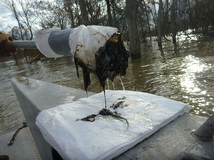
Even following these tips, accidents can still happen. When they do, it’s important that boaters manage them effectively. Spills should immediately be contained and cleaned up with absorbent pads or boomed to prevent their spread. Notify the Coast Guard and your state spill response office, per federal law, and let the marina or fuel dock staff know about the incident, so they can assist. To report an oil spill, call the U.S. Coast Guard National Response Center at 800-424-8802.

Marina with recreational boats. Image credit: NOAA.
Recreational boaters and other small vessel operators can help protect marine life with a few simple precautions aimed at preventing oil from getting into the water. Image credit: NOAA
Node Weight: 
10

Using Dogs to Find Oil During Spill Response

Short title: 
Using Dogs to Find Oil During Spill Response

This project was to validate and better understand the capabilities of trained oil detection canines to locate and delineate subsurface stranded oil. The results of the study have a high probability of immediate, short-term applications and long-term real benefits in the design and implementation of shoreline cleanup assessment technique surveys for stranded oil.

Usually, teams of people trained in the shoreline assessment cleanup techniques, called SCAT, comb for oil buried along shorelines and other areas affected by oil spills. The technique has been an integral part of oil spill response since the Exxon Valdez spill in 1989. It is a systematic approach to describing the “where” and “how much” for spilled oil, and directs cleanup activities during moderate and larger spill incidents.

The SCAT process is labor-intensive and time-consuming, and requires trained personnel to survey areas possibly impacted by an oil spill. In certain habitats—like gravel or sand beaches—oil either penetrates deeply below the surface or becomes buried by material deposited on top, making oil assessment even more difficult. In these cases, SCAT teams must dig pits to determine the existence and extent of buried oil that would require excavation and other more complicated cleanup approaches. The limitations of human-centric SCAT surveys led one of the originators of the first SCAT programs during Exxon Valdez, Ed Owens of Owens Coastal Consultants, to begin discussions with Paul Bunker’s K2 Solutions to determine if the high sensitivity, accuracy and precision of canine noses could be adapted and applied to the task of oil spill shoreline assessment.

This is what led Ed, Paul, Pepper the black lab, her handler Haiden Montgomery, and a host of interested observers from NOAA, the Coast Guard, Exxon-Mobil, Chevron, Polaris Environmental, and the Oil Spill Recovery Institute to make the trip to Prince William Sound, the Alaskan region impacted by Exxon Valdez. The Oil Spill Recovery Institute sponsored the project. Dog teams are already being productively employed for oil assessment in actual spills (Pepper will be traveling to Canada to join her canine colleagues for a river spill assessment).

Scientists from the Office of Response and Restoration observed the trials, assisted in the verification of oil presence, and provided feedback on the use of oil detection dogs in real-time spill situations. Canine detection of buried oil holds real promise for improving the effectiveness and efficiency of oil spill assessment surveys. The methodology will continue to be refined and improved as it is used in real oil spill situations, and as we increase our understanding of how and what the dogs are actually detecting.
 

Gary Shigenaka and Catherine Berg with the Office of Response and Restoration contributed to this article.

Three people on rocky shore with black dog. Image credit: NOAA.
Paul Bunker and Haiden Montgomery assessing the odor of residual Exxon Valdez oil, while Pepper closely supervises the collection of an oil sample by Scott Pegau of the Oil Spill Recovery Institute. Image credit: NOAA.
Catherine Berg, Pepper, and Gary Shigenaka. Image credit: NOAA.
Node Weight: 
6

Preventing and Preparing for Oil Spills in the Arctic

Short title: 
Preventing and Preparing for Oil Spills in the Arctic

May 11, 2017 - As rising temperatures and thinning ice in the Arctic create openings for increased human activities, it also increases the potential for oil spills and chemical releases into the remote environment of the region. Planning emergency response operations for the Arctic falls to the Emergency Prevention, Preparedness and Response working group, an Arctic Council body.

The emergency working group has representatives from each of the member states with expertise in oil spill response, search and rescue, and response to radiological events. NOAA’s Amy Merten, chief of the Spatial Data Branch, will finish her two-year stint as chair of the working group in May 2017. The chair is elected every two years from among the working group’s members including: Canada, Kingdom of Denmark, Finland, Iceland, Norway, Russian Federation, Sweden, the United States and permanent participants.

Merten served on the working group for 5 years before becoming chair. She will leave the position on May 11, 2017. Jens Peter Holst-Andersen, from the Kingdom of Denmark will be the new chair at the next meeting in Vologda, Russia. Merten, who holds a doctorate in marine sciences/environmental chemistry, shared her insights into the complexities of planning for emergencies in the remote regions of the Arctic and about what it’s like working with other nations to protect the Arctic environments.

What are the biggest challenges facing spill response in the Arctic? There are many; remote locations, short windows of open-water and daylight in which to respond, and lack of infrastructure—you can’t send a massive response community to Arctic communities there is not enough food, hotel space, or fuel to sustain larger groups. Lack of communication is another challenge. Things that we take for granted working at moderate temperatures (cameras, GPS), don’t work at cold temperatures. For search and rescue, there is not adequate hospital space or expertise. Therefore, if a large cruise ship gets into trouble in the Arctic, the rescue, triage and sustainability of the passengers will be a major challenge.

Why is it important to have international cooperation when developing response plans? Each country has unique experiences and may have developed a way to respond to oil spills in ice or Arctic conditions that can be shared with other countries facing potential spills in ice. Because of the remoteness of the Arctic, with little to no infrastructure, particularly in the United States and Canada, countries will have to rely on equipment and support from others. Additionally, there are parts of the Arctic Ocean that are international waters, and should a vessel founder there, the countries would collectively respond. We share thoughts on high-risk scenarios, best practices, and identification of research needs. We also share ideas and findings on the latest technologies in communications, oil-in-ice modeling, data management and response technologies.

How does communication with other countries during an emergency work? We have an up-to-date communication list and protocol. This is part of our agreement, the Agreement on Cooperation on Marine Oil Pollution, Preparedness and Response in the Arctic. We also practice our communication connectivity once a year, and conduct an international exercise every two years.

What role do satellites have in preparing for and responding to emergencies in the region? We rely on satellite information for monitoring conditions (weather and ice) and vessel traffic. We would certainly rely on satellite data for an incident in order to plan the response, monitor the extent of the oiling, and understand the weather and ice conditions.

How do the member countries work to share plans so that emergency response is not being duplicated? This is one of the functions of Emergency Prevention, Preparedness and Response working group. It ensures we communicate about domestic projects and plans that may benefit the other nations to maximize the collective effectiveness and avoid duplications.

NOAA’s online environmental mapping tool for the region, Arctic ERMA, now includes polar projections; do the other council countries use Arctic ERMA? They use it during our joint exercises, and we use it to visualize other working group projects, like the Bureau of Safety and Environmental Enforcement-led Pan-Arctic response assets database. We also discuss sharing data across systems and are developing data sharing agreements.

What are the three biggest threats to the Arctic environment? Keeping it a peaceful governance, climate change, and oil spills/chemical spills.

Why is the Arctic environment important to the United States? Arctic weather and climate affects the world’s oceans, weather, and climate, including the Lower 48. The Arctic is replete with energy, mineral, and fishing resources. The Arctic is inhabited by indigenous communities with unique lifestyles that are threatened and need protection. The Arctic is also home to unique flora and fauna that are important for biodiversity, ecological services, and overall healthy environments. As the Arctic becomes more accessible, national security pressures increase.

What would be the worst types of oil spills in the Arctic? This is a hard question to answer but I’d say a spill of a persistent oil that occurs in broken ice during freeze up or thawing periods. During freeze up because it will be difficult to respond, and difficult to track the oil. During thawing because it’s the emergence of primary production for the food web, hunting subsistence practices would be threatened and it could be unsafe to respond due to of the changing ice conditions. It all depends on how far away and difficult it is to get vessels, aircraft, people, and skimmers onsite, and in a way they can operate safely in a meaningful way. A “worst spill” doesn’t have to be a “large” spill if it impacts sensitive resources at key reproductive and growth cycles, or if it impacts Arctic communities’ food security, subsistence activities, and ways of life.

How has being chair added to your understanding of the emergency response in the Arctic? I think it’s increased my concern that it’s not a matter of “if” but a matter of “when” a spill will happen. The logistics of a response will be complicated, slow, and likely, fairly ineffective. The potential for long-term impacts on stressed communities and stressed environments is high. I do have a good feeling that international cooperation will be at its best, but the challenges are daunting for all of us.

Fjord off the coast of Longyearbyen, Svalbard, Norway. Image credit: NOAA.
View off the coast of Longyearbyen, Svalbard, Norway. Taken during a search and rescue demonstration for an Arctic Council’s Emergency Prevention, Preparedness and Response working group meeting. Image Credit: NOAA
Amy Merten on boat with Arctic ice in background. Image credit: NOAA.
NOAA scientist Amy Merten in the Arctic. Merten is chief of the Spatial Data Branch of the Office of Response and Restoration and served as chair of the Arctic Council’s Emergency Prevention, Preparedness and Response working group. Image credit: NOAA.
Node Weight: 
5

Restoration of Industrial Waste Sites

NOAA Ocean Podcast, Episode 05 — 13:49 minutes

May 4, 2017 — An unfortunate by product of some industrial activities is the release of hazardous chemicals and heavy metals into the environment. NOAA Ocean Podcast talked with Reyhan Meharn, NOAA Regional Resource Coordinator with the Assessment and Restoration Division, about moving towards restoration at hazardous industrial waste sites.

Node Weight: 
1
Resources: 

NOAA Corps: 100 Years of Service

Short title: 
NOAA Corps: 100 Years of Service

By Ensign Matthew Bissell, NOAA Corps

May 22, 2017 — Can you name the seven uniformed services of the United States?

Most likely, you can name five—Army, Navy, Marine Corps, Air Force, and Coast Guard. You may even get to six if you know that the U.S Public Health Service has a uniformed division.

What is that seventh uniformed service?

Don’t feel bad if you can’t come up with it, you are not alone, even some members of the military haven’t heard of the NOAA Corps, despite the service approaching its 100-year anniversary.

I experienced the Corps’ low profile first hand when I showed up for my physical screening at the military’s processing station in Los Angeles, California. I was denied entry because the security guard didn’t believe the NOAA Corps was a uniformed service. I only gained entry after proving its existence by pulling up a Wikipedia entry on my phone.

My NOAA Corps affiliation didn’t get me much further once inside. All the other recruits received nametags that read Air Force, Coast Guard, or Marines, mine read XXX. I got more than a few questions about my Xs that day and my responses varied greatly—some more creative than others.

At that early stage in my NOAA Corps career, even I was largely unaware of the rich history and incredibly valuable service I was to become part of.

The Civil War to World War I

NOAA Corps officially began on May 22, 1917 (46 days after the nation entered World War I). To understand the origins of NOAA, and its commissioned Corps, we need to go even further back in history, to 1807 when President Thomas Jefferson signed a bill initiating the first survey of the nation’s coast. The result was the formation of the U.S. Survey of the Coast, later named the U.S. Coast Survey—the nation’s oldest scientific federal agency.

Initially consisting of civilian surveyors, cartographers, and engineers, as well as commissioned officers from the Army and Navy, the agency charted the nation’s waterways.

Once the Civil War erupted in 1861 the Army and Navy officers in the Coast Survey were recalled to their respective services. The survey’s remaining civilians volunteered their skills in support of the Union, serving in both the Army and Navy. In addition to providing valuable mapping and charting services to the Union forces, these civilian surveyors participated in naval blockades and other major offensive actions.

Army commands gave Coast Surveyors military rank while the Navy refused, leaving some coast surveyors in jeopardy of being hung as spies if captured.

When the war ended, the civilian surveyors and Naval officers returned to their charting mission. The scope of this work had now expanded to include a survey of the nation’s interior. In 1878 the U.S. Coast Survey was renamed the U.S. Coast and Geodetic Survey to reflect this new responsibility.

Naval officers were again withdrawn for the Spanish-American War, never to return to the survey. For the next two decades, civilians were in command of the survey ships.

Then in 1915, Ernest Lester Jones, referred to as the father of the NOAA Corps, became director of the organization. With the nation’s involvement in World War I looming, one of Jones’s first actions as director was to publish the coast survey’s contributions to the Civil War. A step that eventually led to establishing the organization as a commissioned service.

NOAA Ship Rainer on ocean. Image credit: NOAA.
NOAA Ship Rainier is a hydrographic survey vessel that maps the ocean to aid maritime commerce, improve coastal resilience, and understand the marine environment. Rainier’s officers, technicians, and scientists log the data that NOAA cartographers use to create and update the nation’s nautical charts with ever-increasing data richness and precision. Image credit: NOAA.
Historical photo of NOAA ship. Image credit: NOAA.
Coast and Geodetic Survey Ship SURVEYOR off Norfolk, Virginia, in 1919, showing Star and Chevron on stack for having taken part in WWI combat operations in the North Atlantic. Image credit: NOAA Photo Library.
Node Weight: 
7

NOAA Adding Polar Projections to Arctic ERMA Mapping Tool

Short title: 
Polar Projections in Arctic ERMA Mapping Tool
Two Steller sea lions. Image credit: NOAA.
Mapping where Steller sea lions gather out of the water is one of the layers that can be added to a map in Arctic ERMA. Image credit: NOAA
Polar projections in Arctic ERMA. Image credit: NOAA.
Polar projection map in Arctic ERMA. The ability to choose several polar projections will improve data and mapping accuracy and will increase communications and data sharing with other Arctic nations. Image credit: NOAA
Node Weight: 
6

Sea Grant Reports: Dolphins, Sea Turtles and the Impacts from Deepwater Horizon

Short title: 
Sea Grant Dolphins, Sea Turtles and Impacts from Deepwater Horizon

April 25, 2017 — Two popular marine animals—dolphins and sea turtles—are the focus of new publications from the Sea Grant Oil Spill Science Outreach Team. In the aftermath of the largest oil spill in history, many expressed concern about its impact on these long-lived, slow-to-mature creatures. Now, almost seven years after the spill, scientists have a better understanding of how they fared. The team examined this research, synthesizing peer-reviewed findings into two easy-to-understand outreach bulletins.

Starting in 2010 a month before the Macondo blowout, scientists documented more than 1,000 stranded dolphins and whales along the northern Gulf of Mexico. From 2010 until 2014, they examined the health and stranding patterns of dolphins along the coasts of Louisiana, Mississippi, Alabama, and Florida, discovering that oiled areas had more sick and dead dolphins. Scientists also found many sick and stranded pre-term and newborn dolphins. Overall, young dolphins in the study area were eight times more likely to have pneumonia or inflamed lungs and 18 times more likely to show signs of fetal distress than those from areas outside the Gulf. The Deepwater Horizon’s impact on bottlenose dolphins report examines all of the factors, including oil that scientists think contributed to dolphin populations’ drop in numbers during this time.

The Sea turtles and the Deepwater Horizon oil spill report details 2010’s impacts on threatened or endangered sea turtles species in the Gulf. In total, scientists estimate that the oil spill and related response activities killed between 95,000 and 200,000 sea turtles. Lasting impacts of these losses may take time to become clear. For example, scientists do not fully understand how oil exposure affects sea turtles’ ongoing reproductive abilities. They continue to monitor sea turtle populations by counting numbers of nests, hatchlings, and adult females on beaches.

More articles about the impacts of Deepwater Horizon on marine mammals:

Tara Skelton is the Oil Spill Science Outreach Team Communicator for the Mississippi-Alabama Sea Grant Consortium. TheSea Grant Oil Spill Science Outreach Program is a joint project of the four Gulf of Mexico Sea Grant College Programs, with funding from partner Gulf of Mexico Research Initiative. The team’s mission is to collect and translate the latest peer-reviewed research for those who rely on a healthy Gulf for work or recreation. To learn more about the team’s products and presentations, visit Sea Grant in the Gulf of Mexico.

A bottlenose dolphin calf in the Gulf of Mexico. Image credit: NOAA
Node Weight: 
6

8 Ways to Keep the Earth Clean

Short title: 
8 Ways to Keep the Earth Clean

By: Amanda Laverty, Knauss fellow with NOAA’s Marine Debris Program

April 18, 2017 — Here at the NOAA Marine Debris Program, Earth Day is every day and we are always encouraging others to get involved and support efforts working toward a clean environment and healthy planet.

Our oceans are filled with items that do not belong there. Huge amounts of consumer plastics, metals, rubber, paper, textiles, derelict fishing gear, vessels, and other lost or discarded items enter the marine environment every day, making marine debris one of the most widespread pollution problems facing the world's ocean and waterways.The ultimate solution to the problem lies with every single one of us—preventing marine debris in the first place.

First, consider how you might personally contribute to marine debris and follow the “4Rs” whenever possible. Refuse unnecessary single-use items, like plastic straws or cutlery when possible. Reduce the amount of waste you produce by choosing products with less packaging. Reuse items when you can and choose reusable items over disposable ones. And, Recycle as much as possible — bottles, cell phones, ink cartridges, and many other items can be recycled.

Next, spread the word to others! Tell your family, friends, community, and more about this important issue and what they can do to help.

Here are a few easy and effective ways you can choose to reduce your daily impact and make a world of difference:

  1. Bring a bag. Remember to bring reusable bags to the grocery store or for any other shopping activities to reduce consumption of disposable bags.
  2. Invest in a reusable water bottle. Acquiring a reusable water bottle would not only greatly reduce the amount of single-use plastic you use, but it would also save you money in the long run! If you’re concerned about the quality of your tap water, consider using a water filter.
  3. Bring your own reusable cup. Think about how many disposable cups are used every day in just your local coffee shop. Bringing a mug for your morning coffee can reduce the amount of waste you produce annually. Imagine how much waste we could reduce if we all made this simple daily change!
  4. Refuse single-use items. Take note on how often you rely on single-use items and choose to replace them with more sustainable versions. Refusing plastic straws and disposable cutlery when you go out and bringing your own containers for leftovers are a few ways you can start today.
  5. Avoid products with microbeads. Facial scrubs and beauty products containing plastic microbeads were banned in the United States in 2015, but won’t be fully phased out until 2019. Read the labels when purchasing products and opt for ones that contain natural scrubbing ingredients like salt or sugar.
  6. Shop in bulk. Consider the product-to-packaging ratio when purchasing items and choose larger containers instead of multiple smaller ones. When you have the option, also consider purchasing package-free foods and household goods.
  7. Make sure your waste goes to the right place. Do your best to ensure that the waste you dispose of ends up where it should. Recycle the materials that are recyclable in your area and make sure to reduce the likelihood of your garbage ending up in the environment by keeping a lid on your trash can when it’s outside.
  8. Compost. Composting at home reduces the volume of garbage sent to landfills and reduces the chance of some products becoming marine debris.

These are just a few ways that we can incorporate taking care of our ocean and Great lakes into our everyday lives. By doing our part to work toward a sustainable and debris-free planet, we’ll also be providing others with inspiration and a good example to follow. As individuals we have the potential to make a big difference and together we can change the world. 

Learn more about NOAA’s Marine Debris Program and its mission to investigate and prevent the adverse impacts of marine debris.

Litter on beach. Image credit: NOAA.
Litter such as plastic detergent bottles, crates, buoys, combs, and water bottles blanket Kanapou Bay, on the Island of Kaho'olawe in Hawaii. This region is a hot-spot for marine debris accumulation. Image credit: NOAA
Site Themes: 
Node Weight: 
12

How to Test for Toxicity

Short title: 
How to Test for Toxicity

April 19, 2017 — What is toxicity? Most definitions would explain it as the degree to which a substance is poisonous.

Knowing a substance’s toxic levels is particularly important to federal agencies that use the information to test potential risks posed to people’s health and to the environment.

So how do scientists know how toxic something is and whether or not that substance—be it oil, chemical treating agents or toxic metals—will be toxic when introduced into marine or coastal waters?

The basic tool for determining toxicity of substances to marine and aquatic organisms is the toxicity test. In its simplest form, toxicity testing is taking healthy organisms from a container of clean water and placing into one containing the same water with a known concentration of a pollutant. The observer then watches to see if, and when, it appears to become lethargic, sick or dies, and comparing those results to the organisms left in the clean water.

Complexities of toxicity testing

The testing process for determining toxicity in marine environments is detailed, rigorous, and time consuming. There must be containers of both the uncontaminated (clean) water (called a control) and the pollutant-treated water; a bare minimum is five containers of each.

The reason for the replications is the concept of variability. Given five test organisms, such as a fish species, there will be a range of sensitivity among them.

Having multiple testing samples allows scientists to determine the level toxic to the average organism and the level toxic to the most sensitive organism. Having more than one of the same organism in each test container is required; ten is standard.

It’s easy to see how a toxicity test grows in complexity: 50 specimens for the controls (10 in each of five replicate containers) and 50 more in the five treated containers (10 in each of five replicate treatment containers). That’s 100 organisms.

But then, to find out what concentrations of the toxicant are safe and which are not, there needs to be at least five different treatment concentrations, each with five containers and each container with 10 test organisms. Now we’re dealing with 600 test organisms and 60 test containers.

Small shore wave with spilled oil.
Oil washes onto the beach on the day of the spill at Refugio State Beach, May 19, 2015. Image credit: NOAA
Node Weight: 
9

Meet the New CAMEO Chemicals Mobile App

Short title: 
Meet the New CAMEO Chemicals Mobile App

April 6, 2017 - The joint NOAA-Environmental Protection Agency hazardous chemicals database is now available as a mobile app.

Named CAMEO Chemicals, the database has information on thousands of chemicals and hazardous substances, including response recommendations and predictions about explosions, toxic fumes, and other hazards. Firefighters and emergency planners around the world use CAMEO Chemicals to help them prepare for and respond to emergencies.

CAMEO Chemicals was already available as a desktop program, website, and mobile-friendly website. You can download the new app to view key chemical and response information on smartphones and tablets. Once downloaded, you can look up chemicals and predict reactivity without an internet connection—making it a valuable tool for emergency responders on the go. With an internet connection, you can access even more resources, like the National Institute for Occupational Safety and Health Pocket Guide to Chemical Hazards and International Chemical Safety Cards.

The app is packed with features, including:

  • Search by name, Chemical Abstracts Service number, or United Nations/North American number to find chemicals of interest in the database of thousands of hazardous substances.
  • Find physical properties, health hazards, air and water hazards, recommendations for firefighting, first aid, and spill response, and regulatory information.
  • Predict potential hazards that could arise if chemicals were to mix.
  • Quickly access additional resources like the U.S. Coast Guard Chemical Hazards Response Information System manual, the National Institute for Occupational Safety and Health Pocket Guide, and International Chemical Safety Cards.
  • Find response information from the Emergency Response Guidebook and shipping information from the Hazardous Materials Table. Emergency Response Guidebook PDFs are available in English, Spanish, and French.
  • Save and share information with colleagues.

The mobile app is part of the CAMEO® software suite, a set of programs offered at no cost by NOAA's Office of Response and Restoration and EPA's Office of Emergency Management. This suite of programs was designed to assist emergency planners and responders to anticipate and respond to chemical spills.

You can download the new CAMEO Chemicals app in the Apple App store or Google Play Store.

Kristen Faiferlick of NOAA's Office of Response and Restoration contributed to this article.

Man in chemical protective mask with fire in background.
Used by firefighters and other emergency responders, our hazardous chemicals database, CAMEO Chemicals, is now available as a mobile app. Image credit: U.S. Air Force
Image of smartphones and tablets.
Our hazardous chemicals database, CAMEO Chemicals, is now available as a mobile app. Image credit: NOAA
Site Themes: 
Node Weight: 
8

Closing Down Damage Assessment After Deepwater Horizon

Short title: 
Closing Down Damage Assessment After Deepwater Horizon

Repurposing samples and equipment: the work goes on

Shutting down the assessment operations involved clearing out laboratories and warehouses filled with samples, field equipment, and supplies. In most instances, only a portion of each sample was needed for analysis and by the end of 2015, NOAA had an extensive trove of environmental samples. Recognizing that many research scientists might put these samples to good use, NOAA made the materials available by publishing announcements in professional society newsletters.

After receiving about one hundred inquiries, staff and contractors began distributing more than 5,000 samples. Additionally, some sample collections were archived in publicly available repositories, with other historical and scientifically valuable collections. Thousands of samples of plankton, fish, and other organisms collected during post-spill trawls in Gulf waters went to a NOAA archive in Stennis, Mississippi. The Smithsonian Institution in Washington, D.C. received rare deep-sea corals.

Later this year the National Marine Mammal Tissue Bank will host thousands of samples from species of dolphins and other marine mammals found dead after the oil spill. Universities across the United States received samples for research. Sediment samples sent to Florida State University in Tallahassee are supporting studies on the long-term fate of Deepwater Horizon oil deposited on Gulf beaches and in nearshore environments. Researchers at Jacksonville University in Florida are using samples to compare the weathering of tar balls found submerged to tar balls those stranded on land. Additionally, researchers at Texas A&M University obtained samples of the spilled oil for studies of bacteria that biodegrade oil.

Finding new homes for scientific instruments and other equipment

Field samples were not the only items distributed to advance oil spill science. NOAA shipped hundreds of large and small pieces of equipment to universities and other research partners to aid ongoing investigations about the effects of oil spills on the environment, and the ongoing monitoring of the Gulf environment. Repurposed supplies and equipment found a second life at many institutions including the:

  • University of Miami
  • NOVA Southeastern University
  • Dauphin Island Sea Lab
  • University of Southern Mississippi
  • University of South Florida
  • Louisiana State University
  • Texas A & M
  • Smithsonian Institution

In addition to laboratory equipment, some university researchers received practical items such as anchors, battery packs, buoys, forceps, freezer packs, glassware, preservatives such as alcohol and formalin, and thermometers. NOAA coordinated with BP to recover and repurpose thousands of items BP purchased for the assessment. While clearing out office buildings and trailers, NOAA staff identified and requested valuable pieces of laboratory and field equipment, and other supplies. Some of these items, such as microscopes, initially cost tens of thousands of dollars. First responders from NOAA and the U.S. Coast Guard also received field safety equipment including:

  • Personal floatation devices
  • Safety goggles
  • Pallets of nitrile gloves
  • Lightning detectors
  • Sorbent boom

All of which support preparedness for future incidents. Countless NOAA staff rose to the enormous challenges of responding to, assessing impacts from, and restoring the natural resources injured by the Deepwater Horizon incident. This work continues, assisted by the creative reuse and repurposing of materials across the country to support ongoing efforts to advance oil spill science and improve preparedness for future spills. Read more about Deepwater Horizon and the work of NOAA’s Office of Response and Restoration and partners in responding to the spill, documenting the environmental damage, and holding BP accountable for restoring injured resources:

Greg Baker, Rob Ricker, and Kathleen Goggin of NOAA’s Office of Response and Restoration contributed to this article.

Shelves of samples in jars.
The plankton archive contains over 130,000 samples from 19 different surveys conducted as part of the natural resources damage assessment. Plankton archive located at the Stennis Space Center in Mississippi. Image credit: NOAA
Graphic with gloved hands pouring liquid from sample jar into beaker and numbers
Image credit: NOAA
Node Weight: 
21

Deepwater Horizon: Response in the Midst of an Historic Crisis

Short title: 
Deepwater Horizon Response of an Historic Crisis

April 3, 2017 — The Deepwater Horizon oil spill began on April 20, 2010, with a blowout of BP's Macondo drilling platform in the Gulf of Mexico. In addition to the death of 11 men, the spill resulted in the largest mobilization of resources addressing an environmental emergency in the history of the United States.

The size of the spill required the Emergency Response Division to refine tracking subsurface oil, flowrate calculations, and long-term oil transport modeling. Data and information management became a paramount issue. NOAA’s web-based environmental management mapping tool proved invaluable in tracking and sharing data across the many teams and command posts.

With only 12 full time responders and about 120 NOAA staff nationally, the size and complexity of the incident taxed the spill team’s capacity to respond. NOAA recruited retired staff and contractors to provide additional emergency support, along with scientists from across the nation and internationally.

Other NOAA programs provided critical services in the field, on ships, aircraft, and in regional laboratories, weather forecast offices, and regional command posts. As the response grew, staffing the various missions required extraordinary interagency coordination.

Overall, several thousand NOAA staff worked on spill response and damage assessment activities. Seven NOAA ships—39 percent of the NOAA fleet—conducted cruises with missions as diverse as seafood safety monitoring, wellhead monitoring, and detecting subsurface oil. Five NOAA aircraft flew over 773 flight hours to track the oil spill and to measure air quality impacts.

Challenges faced with Deepwater Horizon

Forecasting the oil’s movement: How would the Loop Current effect the oil’s potential to spread to the Florida Keys and beyond? To answer that staff worked 24-7 modeling where the oil might spread in an effort to help defuse the public’s concern that oil would rapidly travel around Florida and oil shorelines along the Atlantic seaboard. After more than a month of daily mapping, overflights, and satellite analyses, our data showed no recoverable oil in the area, and the threat of oil spreading by the Loop Current diminished.

Calculating how much oil spilled and where it went: Estimating the size of an oil spill is difficult, and determining the volume spilled from this leaking wellhead over a mile deep was even more challenging. Federal scientists and engineers worked with experts from universities on interagency teams to calculate the flow rate and total volume of oil spilled.

Another interagency team, led by the U. S. Geological Survey, NOAA, and the National Institute of Standards and Technology developed a tool called the Oil Budget Calculator to determine what happened to the oil. Working with these experts and agencies, NOAA was able to estimate the amount spilled, and how much oil was chemically dispersed, burned, and recovered by skimmers.

NOAA scientists also studied how much oil naturally evaporated and dispersed, sank to the sea floor, or trapped in shoreline sediments. Other studies determined how long it took the oil to degrade in those different environments.

While dispersant use reduced the amount of surface and shoreline oiling, and reduced marsh impacts, dispersants likely did increase impacts to some species during sensitive life stages that live in the water column and the deep ocean. The use of dispersants is under review.

Quickly communicating the science of the situation including: The public demanded answers fast, and social media rapidly took over as a primary tool to voice their concerns. We responded with continual updates through social media and on our website and blog. Still, keeping ahead of misconceptions and misinformation about the spill proved challenging. The lesson learned is that we can't underestimate social media interest.

In addition to responding to the public’s need for accurate information, NOAA had to coordinate with universities and other academics to and quickly leverage existing research on an active oil spill. The size and multi-month aspect of the spill generated huge academic interest, but also meant that scientists were mobilizing and conducting field activities in the middle of an active response.

Tractor with trailers on beach.
Cleanup crews in Pensacola Beach, Florida, try to remove oil from the sand in November 2010. The Deepwater Horizon oil spill that severely injured the environment also directly affected the seafood trade and tourism economies of five Gulf states. Image Credit: NOAA
Infographic about Deepwater Horizon.
Statistical information about Deepwater Horizon. Image Credit: NOAA
Node Weight: 
8

Assessing the Impacts from Deepwater Horizon

Short title: 
Assessing the Impacts from Deepwater Horizon

Evaluating impacts from the spill

Considering these interdependencies during the assessment process was important. At the same time, it was impossible to test or examine every injured bird, every sickened dolphin, or every area contaminated with oil. That was cost prohibitive and scientifically impossible. Instead, NOAA scientists evaluated representative samples of natural resources, habitats, ecological communities, ecosystem processes and linkages. To do that, scientists made 20,000 trips to the field, to obtain 100,000 environmental samples that yielded 15 million records. This data collection and subsequent series of scientific studies formed the basis for the natural resources damage assessment that led to the largest civil settlement in federal history.

A short summary of the natural resource injuries: Marshes Injured

  • Plant cover and vegetation mass reduced along 350 to 720 miles of shoreline.
  • Amphipods, periwinkles, shrimp, forage fish, red drum, fiddler crabs, insects killed.

Harvestable oysters lost

  • 4 – 8.3 billion harvestable oysters lost

Birds, fish, shellfish, sea turtles, and dolphins killed

  • Between 51,000 to 84,000 birds killed
  • Between 56,000 to 166,000 small juvenile sea turtles killed
  • Up to 51% decrease in Barataria Bay dolphin population
  • An estimated 2 – 5 trillion newly hatched fish were killed

Rare corals and red crabs impacted

  • Throughout an area about 400 to 700 square miles around the wellhead

Recreational opportunities lost

  • About $527 - $859 million in lost recreation such as boating, fishing, and beach going

What we shared

Those studies not only documented the injuries, but also helped the entire scientific community understand the effects of oil spills on nature and our communities. All of the scientific studies, including over 70 peer-reviewed journal articles, as well as all the data collected for the studies, are available to the public and the scientific community. Additionally, our environmental response management software allows anyone to download the data from a scientific study, and then see that data on a map. We will be publishing new guidance documents regarding sea turtles and marine mammals by the end of 2017. These guides compile best practices and lessons learned and will expedite natural resources damage assessment procedures in the future. Read more about Deepwater Horizon and the work of NOAA and partners in responding to the spill, documenting the environmental damage, and holding BP accountable for restoring injured resources:

Tom Brosnan, Lisa DiPinto, and Kathleen Goggin of NOAA’s Office of Response and Restoration contributed to this article.

Beach with oats and grass.
Beach habitat was part of the Deepwater Horizon oil spill settlement. Image Credit: NOAA
Top fish without oil, bottom fish with oil.
The top picture is a red drum control fish that was not exposed to oil, while the bottom red drum fish was exposed to Deepwater Horizon oil for 36 hours. The bottom fish developed excess fluid around the heart and other developmental deformities. This is an example of the many scientific studies conducted for the natural resources damage assessment. Image Credit: NOAA/Abt
Node Weight: 
6

High Water and Sunken Oil on the Great Mississippi

Short title: 
High Water and Sunken Oil on the Great Mississippi

March 29, 2017 - If you can’t see spilled oil, how do you find it and clean it up?

That’s the situation emergency responders faced in two oil spills on the Mississippi River that challenged their understanding of how to approach evaluating oil spill conditions.

The first incident was Sept. 3, 2015 when two tow barges collided on the Lower Mississippi River near Columbus, Kentucky. The second was Jan. 21, 2016 when a barge towed by the UTV Amy Frances struck the Natchez Bridge on the Lower Mississippi River. The Lower Mississippi is the most traveled and commercially important portion of the river’s system.

In both instances, the U.S. Coast Guard requested assistance from the National Oceanic and Atmospheric Administration. NOAA’s Office of Response and Restoration has scientific support coordinators stationed throughout the country to respond to spill emergencies.

The two incidents also spilled slurry oil—a byproduct of the oil refining process, which is denser than water and so, sinks instead of floating on the water’s surface. Despite understanding the scientific attributes of the oil, the responders needed to know where it was and how it would react to the river’s high water conditions.

“Just because you know the physical properties doesn’t tell you it will stay in one piece or get torn to bits and scattered all over the river bottom,” said Adam Davis, NOAA scientific support coordinator in the Gulf of Mexico who responded to both spills. “What we didn’t know was how it would interact with the river bottom and whether the best practice assessment tools would work given the river conditions at the time.”

In other words, would the oil sink and go straight to the bottom as one coherent mass or, would the currents tear it into pieces and take it downstream over a larger area? Or, would the oil be rapidly buried and evade the ability to locate and recover it?

Damaged barge.
A view of the damaged barge Apex 3508, whose tug boat collided with another on Sept. 2, 2015, causing an oil spill on the Mississippi River near Columbus, Kentucky. The rest of the oil on board the barge was removed. Credit: U.S. Coast Guard

Locating sunken oil in a large, dynamic river like the Lower Mississippi can be daunting. Fortunately, In the case of the Apex 3508 barge collision in Kentucky, the response team was able to use sophisticated side scan sonar and multibeam sonar to locate the oil and map the river bottom. Additionally, a novel dredging technique using an environmental clamshell-dredging device proved effective in recovery.

By the time of the Natchez Bridge incident, the river had moved from its low water condition typical of late summer to the extreme high water associated with seasonal spring flooding. Measurements showed the river raged from 8-13 knots (9-14 miles per hour) and was discharging about 1.8 million cubic feet of water per second. The response team again used side scan and multibeam sonar, but in this instance more to understand how the high flow conditions would affect what was going on along the river bottom. The multibeam imagery showed 30-50 foot tall sand waves were moving along the river bottom at a rate of about 30 feet in about two hours.

“Given the immense amount of sediment being transported rapidly downstream as evidenced by the multibeam imagery, we immediately knew that any oil that had found its way to the bottom near mid channel had been rapidly buried by the next massive sand wave and was unlikely to be recovered any time soon,” Davis said.

When the river is moving swiftly, the safest place for a damaged barge that can't be transported to a fixed facility is often along the riverbank. The problem with a leaking barge pushed in along a flooded riverbank is that it is hard and often dangerous to assess the leakage. This was certainly the case in the Natchez incident.

"We knew the side scan and multibeam tools simply wouldn't work well up close to the barge, Davis said. “There was just too much interference caused by the barge and the flooded trees along the bank to be able to see what was going on.”

The typical snare drag or probing for oil would not work in the high water conditions either. The equipment would snag on debris and vegetation below the water’s surface, and operating a vessel in a flooded tree line was unsafe.

 Makeshift cotton-swab tool.
The makeshift “cotton swab” tool created to collect oil samples from the submerged trees along the flooded riverbank during the response to the Amy Frances incident. Credit: NOAA

“In order to probe we needed an object that could be easily and quickly fabricated from items on-hand,” Davis said. “The right tool didn’t exist, the solution called for a little ingenuity and quick action.”

With the barge pushed in to the bank, securely tied off, and under the control of the tow, it offered a stable and safe enough platform for the response team to take a long pole with its ends wrapped in sorbent material and probe along the shore side. The new tool looked like a giant cotton swab and proved effective in quickly confirming the presence of sunken oil along the bank. “Often I find that people are quite surprised that oil spill response strategies can be pretty low-tech sometimes and still be effective,” Davis said. “In the ‘NCIS’ age of ‘isn’t there a high tech gadget that can just easily fix your complex and dynamic problem’? Sometimes it is hard to convey that to people.”

Despite standards for evaluating oil spills, every spill has its unique challenges that require a deep understanding of science and an ability to think creatively.

Man in orange uniform looking at wrecked barge on river.
USCG conducting initial damage survey of barge from the UTV Amy Frances. Credit: U.S. Coast Guard
Node Weight: 
9

Consent Decree Approved to Restore an Urban Dump Near Baltimore

Short title: 
Restoring an Urban Dump Near Baltimore
Brown reeds along creek bank.
Reeds cover large portions of the wetlands. These areas will be restored through proposed methods such as changing the water flow and using chemical control. (Credit: NOAA)
Aerial view of Baltimore with rivers.
68th Street Dump site was once the site of seven landfills. The blue outlined area shows the site. This aerial view was created using NOAA’s Environmental Response Management Application® (Credit NOAA).
Node Weight: 
1

Life at Sea or Scientist on Land: NOAA Corps Offers Both

Short title: 
Life at Sea or Scientist on Land: NOAA Corps Offers Both

By Cmdr. Jesse Stark, NOAA Corps

March 14, 2017 - A life at sea, or a career conserving natural resources?

That was the choice I was contemplating while walking along the docks in Port Angeles, Washington, back in 1998. A chance encounter that day with the chief quartermaster of National Oceanic and Atmospheric Administration Ship Rainer showed me I could do both.

Growing up in the Pacific Northwest I spent my time exploring the woods, beaches, and tide pools. Every summer I reread Jack London's “The Sea Wolf”, and Herman Melville's “Moby Dick.” My first job was a as a deck hand on charter fishing boats out of Port Angeles.

So, when Quartermaster Bernie Greene invited me aboard that day and told me stories with a sense of adventure, I signed onto the Rainer as an able-bodied seaman, and we headed to Alaska. That first voyage had me hooked and I joined NOAA Corps, leading to my current assignment as the Northwest scientific support coordinator.

NOAA has a long history of supplying scientific support to oil spills, starting with the Argo Merchant incident in 1976, and NOAA Corps history stretches back even farther to President Thomas Jefferson’s order for the first survey of the nation’s coast.

Today, the corps’ commissioned officers command NOAA's fleet of research and survey vessels and aircraft, and also rotate to serve within each of NOAA's other divisions. That combination of duties offers a breadth of experience that I draw upon in my current post in NOAA's Office of Response and Restoration's Emergency Response Division.

In the event of an oil spill or chemical release, the U.S. Coast Guard has the primary responsibility for managing clean-up activities; the scientific support coordinator’s role is to provide scientific expertise and to communicate with other affected agencies or organizations to reach a common consensus on response actions.

During my 18-year career as a corps officer, I’ve had eight permanent assignments, four on ships and four on land in three different NOAA divisions. Those different assignments allowed me to develop skills in bringing resources and differing perspectives together to work toward a common goal. Often, operating units get stagnant and stove-piped, and having new blood with new perspective and outlook rotating through alleviates some of that.

It’s also enabled me to build relationships across different divisions and tie together processes and practices among the different operating units, and sometimes, competing ideologies.

As an example, my first land assignment was with NOAA Fisheries’ Protected Resources Division in Portland, Oregon. While there, I produced a GIS-based distribution map of each recorded ocean catch of salmon and steelhead by watershed origin. While this project involved mainly technical aptitude and data mining, I was also involved with writing biological opinions on research authorizations of endangered salmon species.

This required coordination of many competing and differing viewpoints on management of these species. Consensus had to be reached and often an impasse had to be broken among people with deep passions on these issues.

One of my most challenging assignments was in 2010 when I was executive officer of NOAA Ship Pisces that responded to the Deepwater Horizon oil spill.

During the Deepwater Horizon response, the normal collecting of living marine resource data was replaced with a new process of collecting water and sediment samples better suited to the situation. The incident also showed how industry and government can, and must, work side by side for the good of the public and natural resources.

All of these skills together are proving to come in handy as a science coordinator, where in any given situation there can be as many as five different federal agencies, three state agencies, and several private companies with differing opinions. I’m happy to put my skills and experiences to good use in teamwork building and consensus for the greater good.

Commander Stark joined NOAA’s Emergency Response Division in August 2016. Stark’s previous assignment was commanding officer of the NOAA ship Oscar Dyson in Alaska. Stark started in NOAA as a seaman on the NOAA Ship Rainer in 1998 and was commissioned into the NOAA Corps in 1999.

Large white ship with green hills in background.
NOAA Ship Rainier is a hydrographic survey vessel that maps the ocean to aid maritime commerce, improve coastal resilience, and understand the marine environment. Credit: NOAA
Uniformed man holding little girl.
Commander Jesse Stark holding daughter Izzie on NOAA Ship Pisces after a ceremony in Pascagoula, Mississippi at a ceremony donating an anchor to the city for its “Anchor Village,” a retail park constructed near the ship’s homeport after Hurricane Katrina. Credit: NOAA
Node Weight: 
6

Hold on to Those Balloons: They Could End Up in the Ocean

Short title: 
Hold on to Those Balloons: They Could End Up in the Ocean
Sea turtle being held with string in mouth.
Balloon debris can be harmful for wildlife, which may ingest or get entangled in it. Here, a sea turtle was found after ingesting balloon debris, likely mistaking it for food. (Photo Credit: Blair Witherington, Florida Fish and Wildlife Conservation Commission)
Blue and white mylar balloon on beach.
Balloons that are intentionally or accidentally released have to come down somewhere! Unfortunately, they often find their way into our waterways or ocean. (Photo Credit: Russ Lewis)
Node Weight: 
6

Pages

Subscribe to response.restoration.noaa.gov RSS