Back to top

Texas City "Y" Incident: Aftermath of the Oil Spill in Galveston Bay, Texas

Short title: 
Texas City "Y" Incident: Aftermath of the Oil Spill

Surveying Oiled Shorelines

After an oil spill like this one happens along the coast, spill responders need to figure out and document where oil has come ashore, what habitats have been affected, and how to clean up the shoreline. NOAA helped develop a systematic method for surveying an affected shoreline after an oil spill. This method, known as Shoreline Cleanup Assessment Technique (SCAT), is designed to support decision-making for shoreline cleanup. We have SCAT experts helping coordinate these shoreline surveying efforts for the oiled beaches in Texas. In general, SCAT surveys begin early in the response to assess initial shoreline conditions (including even before oil comes ashore, as a reference) and ideally continue to work in advance of cleanup. Surveys continue during the response to verify shoreline oiling, cleanup effectiveness, and eventually, to conduct final evaluations of shorelines to ensure they meet standards for ending cleanup. SCAT teams include people trained in the techniques, procedures, and terminology of shoreline assessment. Members of a SCAT team may come from federal agencies (usually from the NOAA Scientific Support Team or U.S. Coast Guard), state agencies, a representative of the organization responsible for the spill, and possibly the landowner or other local stakeholders. While out walking the shoreline, SCAT team members prepare field maps and forms detailing the area surveyed and make specific cleanup recommendations. Later, they go back to the areas surveyed to verify cleanup effectiveness, modifying guidelines as needed if conditions change. The data they collect informs a shoreline cleanup plan that maximizes the recovery of oiled habitats and resources, while minimizing the risk of injury from cleanup efforts. This means, for example, determining whether active cleanup is necessary or whether certain limitations on cleanup are needed to protect ecological, economic, or cultural concerns.

photo of people removing oil-contaminated sand from beach.
Task force members remove oil-contaminated sand from the beach on Matagorda Island, Texas, March 30, 2014. Cleanup operations are being directed by a unified command comprised of personnel from the Texas General Land Office, U.S. Coast Guard and Kirby Inland marine. (U.S. Coast Guard)
Photo of two people locating oil on a beach.
Two members of the Shoreline Assessment Team locate oiled impact points on Matagorda Island, March 29, 2014. The Unified Command in Port O'Connor is overcoming logistical challenges posed by the remote island in order to clean up the migrating oil from the Texas City collision. (U.S. Coast Guard)
Node Weight: 
2

Oil Seeps, Shipwrecks, and Surfers Ride the Waves in California

Short title: 
Oil Seeps, Shipwrecks, and Surfers Ride the Waves in California

APRIL 1, 2014 -- What do natural oil seeps, shipwrecks, and surfers have in common? The quick answer: tarballs and oceanography. The long answer: It's a longer story ...

A rash of tarballs, which are thick, sticky, and small pieces of partially broken-down oil, washed ashore at Half Moon Bay, Calif., south of San Francisco back in mid-February.

This isn't an unusual occurrence this time of year, but several of those involved in spill response, including NOAA Scientific Support Coordinator Jordan Stout, still received phone calls about them and decided to check things out.

Winds and ocean currents are the primary movers of floating oil. A quick look at conditions around that time indicated that floating stuff (like oil) would have generally been moving northwards up the coast.

Off of Monterey Bay, there had been prolonged winds out of the south several times since December, including just prior to the tarballs' arrival. Coastal currents at the time also showed the ocean's surface waters moving generally up the coast. Then, just hours before their arrival, winds switched direction and started coming out of the west-northwest, pushing the tarballs ashore.

Seeps and Shipwrecks

It's common winter conditions like that, combined with the many natural oil seeps of southern California, that often result in tarballs naturally coming ashore in central and northern California. Wintertime tarballs are not unheard of in this area and people weren't terribly concerned. Even so, some of the tarballs were relatively "fresh" and heavy weather and seas had rolled through during a storm the previous weekend. This got some people thinking about the shipwreck S/S Jacob Luckenbach, a freighter which sank near San Francisco in 1953 and began leaking oil since at least 1992.

When salvage divers were removing oil from the Luckenbach back in 2002, they reported feeling surges along the bottom under some wave conditions. The wreck is 468 feet long, lying in about 175 feet of water and is roughly 20 miles northwest of Half Moon Bay. Could this or another nearby wreck have been jostled by the previous weekend’s storm and produced some of the tarballs now coming ashore?

Tarball on beach with ruler.
A tarball which washed up near California's Half Moon Bay in mid-February 2014. (Credit: Beach Watch volunteers with the Farallones Marine Sanctuary Association)
Node Weight: 
3

Looking for Information about Oil Spills?

Short title: 
Information about Oil Spills

Spill Response and Cleanup

Oil and Oil Spills

A cleanup worker uses a rake to gather oil on the shore of the Texas City Dike.
A cleanup worker gathers oil on the shore of the Texas City Dike, March 24, 2014, in response to the oil spill that occurred March 22, after a bulk carrier and a barge collided in the Houston Ship Channel near Texas City, Texas. (U.S. Coast Guard)
Node Weight: 
2

Kirby Barge Oil Spill, Houston/Texas City Ship Channel, Port Bolivar, Texas

Short title: 
Kirby Barge Oil Spill

Expected Behavior of the Spilled Oil

Intermediate fuel oils are produced by blending heavy residual oils with a light oil to meet specifications for viscosity and pour point. Their behavior can be summarized as follows:

  • IFO-380 will usually spread into thick slicks which can contain large amounts of oil. Oil recovery by skimmers and vacuum pumps can be very effective, particularly early in the spill.
  • Very little of this is likely to mix into the water column. It can form thick streamers or, under strong wind conditions, break into patches and tarballs.
  • IFO-380 is a persistent oil; only a relatively small amount is expected to evaporate within the first hours of a spill. Thus, spilled oil can be carried long distances by winds and currents.
  • IFO-380 can be very viscous and sticky, meaning that stranded oil tends to remain on the surface rather than penetrate sediments. Light accumulations usually form a “bath-tub ring” at the high-water line; heavy accumulations can pool on the surface.
  • Floating oil could potentially sink once it strands on the shoreline, picks up sediment, and then is eroded by wave action.
Trajectory Summary

The incident occurred just inside the entrance of Galveston Bay. Northeasterly winds are expected to carry the oil out of the Bay, but onshore winds expected midweek could bring the oil back along the ocean beaches. The oil, likely in the form of tarballs, could be spread over a large section of ocean beaches.

Photo of oil on the beach following the oil spill in Galveston Bay.
Oil on the beach following the oil spill in Galveston Bay. (U.S. Fish and Wildlife Service)
Photo of tugs and barge in water.
A Coast Guard response boat patrols the Kirby Barge 27706 during cleanup efforts near TexasCity Dike, March 23, 2014. The oil spill occurred, Saturday, after a collision between a bulk carrier and the barge. (U.S. Coast Guard)
Node Weight: 
5

25 Years Later: Timeline of Recovery from Exxon Valdez Oil Spill

Short title: 
25 Years Later: Timeline of Recovery from Exxon Valdez Oil Spill

Twenty-five years after what used to be the largest oil spill in U.S. waters, we show the timeline of recovery for marine life and habitats following the Exxon Valdez oil spill.

Above is a timeline showing when natural resources appear to be recovered, as determined by the National Oceanic and Atmospheric Administration (NOAA). NOAA made this determination with data taken from the Exxon Valdez Oil Spill Trustee Council's 2010 Update on Injured Resources and Services (www.evostc.state.ak.us), U.S. Geological Survey, and NOAA's Office of Response and Restoration. This infographic was produced by NOAA.

Read a report by Gary Shigenaka summarizing information about the Exxon Valdez oil spill and response along with NOAA's role and research on its recovery over the past 25 years.

Node Weight: 
2

Remembering the Exxon Valdez: Collecting 25 Years of Memories and Memorabilia

Short title: 
Remembering the Exxon Valdez: Collecting 25 Years of Memories and Memorabilia
A man in a tyvek suit stands on a ship next to a life preserver in Alaska.
NOAA marine biologist Gary Shigenaka in 1989 aboard the tanker Exxon Valdez itself. In retrospect, Shigenaka joked that he should have made off with the ship's life preserver for his eventual collection of artifacts related to the ship and spill. (NOAA)
Calendar for March 1989 with image of Exxon Valdez ship.
In an ironic twist of fate, the Exxon Shipping Company’s safety calendar featured the tanker Exxon Valdez in March 1989, the same month the ship ran aground. Image: From the collection of Gary Shigenaka.
Node Weight: 
6

Detecting Changes in a Changing World: 25 Years After the Exxon Valdez Oil Spill

Short title: 
Detecting Change in a Changing World: 25 Years After the Exxon Valdez Oil Spill

MARCH 21, 2014 -- Life between high and low tide along the Alaskan coast is literally rough and tumble. The marine animals and plants living there have to deal with both crashing sea waves at high tide and the drying heat of the sun at low tide. Such a life can be up and down, boom and bust, as favorable conditions come and go quickly and marine animals and plants are forced to react and repopulate just as quickly. But what happens when oil from the tanker Exxon Valdez enters this dynamic picture—and 25 years later, still hasn't completely left? What happens when bigger changes to the ocean and global climate begin arriving in these waters already in flux?

Telling the Difference

In the 25 years since the Exxon Valdez oil spill hit Alaska’s Prince William Sound, NOAA scientists, including marine biologist Gary Shigenaka and ecologist Alan Mearns, have been studying the impacts of the spill and cleanup measures on these animals and plants in rocky tidal waters. Their experiments and monitoring over the long term revealed a high degree of natural variability in these communities that was unrelated to the oil spill. They saw large changes in, for example, numbers of mussels, seaweeds, and barnacles from year to year even in areas known to be unaffected by the oil spill. This translated into a major challenge. How do scientists tell the difference between shifts in marine communities due to natural variability and those changes caused by the oil spill? Several key themes emerged from NOAA's long-term monitoring and subsequent experimental research:

  • impact. How do we measure it?
  • recovery. How do we define it?
  • variability. How do we account for it?
  • subtle connection to large-scale oceanic influences. How do we recognize it?

What NOAA has learned from these themes informs our understanding of oil spill response and cleanup, as well as of ecosystems on a larger scale. None of this, however, would have been apparent without the long-term monitoring effort. This is an important lesson learned from the Exxon Valdez experience: that monitoring and research, often viewed as an unnecessary luxury in the context of a large oil spill response, are useful, even essential, for framing the scientific and practical lessons learned.

Left, gold-brown seaweed. Right, a sea snail grazes on seaweed on a rock.
Left, this gold-brown seaweed, known as rockweed (Fucus distichus), is abundant on the shorelines of Alaska’s Prince William Sound. Right, a sea snail known as a limpet (Lottia scutum) grazes its way across the seaweed buffet on a rock in the intertidal zone. (NOAA)

Remote Possibilities

As NOAA looks ahead to the future—and with the Gulf of Mexico's Deepwater Horizon oil spill in our recent past—we can incorporate and apply lessons of the Exxon Valdez long-term program into how we will support response decisions and define impact and recovery. The Arctic is a region of intense interest and scrutiny. Climate change is opening previously inaccessible waters and dramatically shifting what scientists previously considered "normal" environmental conditions. This is allowing new oil production and increased maritime traffic through Arctic waters, increasing the risk of oil spills in remote and changing environments. If and when something bad happens in the Arctic, how do scientists determine the impact and what recovery means, if our reference point is a rapidly moving target? What is our model habitat for restoring one area impacted by oil when the "unimpacted" reference areas are undergoing their own major changes?

Listening in

NOAA marine biologist Gary Shigenaka explores these questions as he reflects on the 25 years since the Exxon Valdez oil spill in the following Making Waves podcast from the National Ocean Service: [NARRATOR] This all points back at what Gary says is the main take-away lesson after 25 years of studying the aftermath of this spill: the natural environment in Alaska and in the Arctic are rapidly changing. If we don't understand that background change, then it's really hard to say if an area has recovered or not after a big oil spill.

[GARY SHIGENAKA] "I think we need to really keep in mind that maybe our prior notions of recovery as returning to some pre-spill or absolute control condition may be outmoded. We need to really overlay that with the dynamic changes that are occurring for whatever reason and adjust our assessments and definitions accordingly. I don't have the answers for the best way to do that. We've gotten some ideas from the work that we've done, but I think that as those changes begin to accelerate and become much more marked, then it's going to be harder to do."

Listen to the full interview with Gary. Read a report by Gary Shigenaka summarizing information about the Exxon Valdez oil spill and response along with NOAA's role and research over the past 25 years.

Two people wearing chest waders sift for marine life in shallow rocky waters.
In 2011 NOAA marine biologist Gary Shigenaka (right) sifts through the sediments of Alaska’s Lower Herring Bay, looking for the tiny marine life that live there. (Photo by Gerry Sanger/Sound Ecosystem Adventures)
Pacific blue mussels (Mytilus trossulus) line a rocky shoreline.
Pacific blue mussels (Mytilus trossulus) line the rocks which are alternately submerged and exposed by the changing tides. (NOAA)
Node Weight: 
4

Report: The Exxon Valdez Oil Spill Revisited 25 Years Later

Short title: 
25 Year Report on Exxon Valdez Oil Spill

March 24, 2014 marks the 25th anniversary of the Exxon Valdez oil spill.

NOAA's Office of Response and Restoration (OR&R) remembers the fateful spill, its devastating impacts, and the many challenges that the spill response presented—geographic remoteness, rugged shorelines, severe weather, sensitive habitats, and threatened commercial and subsistence fisheries.

OR&R's new report, Twenty-Five Years After the Exxon Valdez Oil Spill, describes the accident, the multi-agency response, and the catastrophic toll that this spill had on the Alaskan environment.

Authored by NOAA marine biologist Gary Shigenaka, the report revisits the details of the spill, tells the story of NOAA's role in spill response from its beginnings in the mid-1970s, and then explains how the two came together during the Exxon Valdez oil spill in a technical effort that would span a quarter century and outlive the ship itself.

Download the report: Twenty-Five Years After the Exxon Valdez Oil Spill: NOAA's Scientific Support, Monitoring, and Research [PDF, 11MB]

The early spill response support that NOAA provided in 1989 includes the same general products and services that it offers today—although the current versions boast advanced scientific underpinnings. These included:

  • oil overflights and mapping.
  • modeling the spill's trajectory.
  • identifying plants, animals, habitats, and other resources initially at risk from the spill.

As the spill and its response grew in magnitude and complexity, NOAA worked with other government agencies to provide technical expertise on a broad range of issues, such as:

  • evaluating the feasibility and effectiveness of cleanup methods.
  • chemically determining the sources of oil found in the environment.
  • assessing the safety of subsistence seafood.
  • estimating the quantity and modeling the fate of the spilled oil.
  • managing the enormous volumes of information that the response generated.

Monitoring the Shoreline

During the first year of the response, aggressive shoreline cleanup included the widespread use of high-pressure hot water to remove persistent oil from the beaches. Recognizing that the use of methods like this might itself inflict harm to treated intertidal communities independent of that from oil, NOAA began a decade-long shoreline monitoring program that yielded a number of insights into oil and cleanup impacts and the nature of recovery on the intertidal shorelines of Prince William Sound.

Although the early results of the monitoring confirmed that aggressive cleanup did inflict a greater degree of impact on shoreline communities than oil alone, the affected organisms appeared to compensate for the deficit within a two- to three-year period. Within three to six years, biological communities on oiled shorelines were comparable to those on unoiled reference beaches. Life in the intertidal zone is literally rough and tumble, and the organisms that favor that niche have life cycles and employ reproductive and competitive strategies that can quickly repopulate disturbed areas—such as those caused by oil spills and cleanup.

However, monitoring over the long term revealed a high degree of natural variability in intertidal communities that was unrelated to the oil spill, as large changes were documented from year to year even at those sites known to have been unaffected by the oil spill. This translated into a substantial monitoring challenge: i.e., distinguishing between shifts in biological communities attributable to inherent natural variability from changes caused by the spill. How the NOAA research team accomplished this is explained in the report.

Experimental Investigations

After a decade, NOAA's long-term monitoring program wound down and the scientific team transitioned to a set of experimental investigations focusing on questions that arose from the 10 years of study of Exxon Valdez shoreline impacts. For example: Would an intense pulse of disturbance like an oil spill and cleanup set in motion a series of successional "waves" in the biological communities that would recede only slowly with time? Would aggressive cleanup on a gravel beach physically alter the habitat to the extent that biological recovery would be delayed?

In 1999 and 2000, two experiments were launched in Kasitsna Bay (Cook Inlet) and Lower Herring Bay (Prince William Sound) to specifically address these questions. The answers would both match anticipated outcomes—and surprise us. The experiments and their results are summarized in the 25-year report.

What We Observed

The themes that emerged from NOAA's long-term monitoring and the subsequent experimental research were the following:

  • impact.
  • recovery.
  • variability.
  • subtle connection to large-scale oceanic influences that may help to explain at least a portion of the variability.

None of this, however, would have been apparent in the absence of the long-term monitoring effort. This in itself is an important lesson learned from the Exxon Valdez experience: that monitoring and research, often viewed as an unnecessary luxury in the context of a large spill response, are useful, even essential, for framing the scientific and practical lessons learned.

Implications for the Present and Future

As we look forward, to the future, and with the Deepwater Horizon experience in our recent past, we can incorporate and apply lessons of the Exxon Valdez long-term program into how we will support response decisions and define impact and recovery.

The Arctic is a region of intense interest and scrutiny as oil production becomes a reality, and climate change opens previously inaccessible waters and dramatically shifts baselines of environmental normality there. If and when something bad happens, how do we discern the impact and determine what recovery means, if our reference point is a rapidly moving target? To what do we restore an impacted habitat when the unimpacted reference ... is not?

In a sad and somehow fitting footnote to the recounting of the science and monitoring that have transpired over the last 25 years, and why it is still relevant to the future of oil spill response and assessment, the tale of the fate of the Exxon Valdez, the tanker itself, is provided as the coda to the story.

Aerial view of the Exxon Valdez, surrounded by oil boom.
Node Weight: 
2

After the Big Spill, What Happened to the Ship Exxon Valdez?

Short title: 
After the Big Spill, What Happened to the Ship Exxon Valdez?

MARCH 19, 2014 -- A popular myth exists that it is bad luck to rename a boat.

It is unclear whether this applies to "boats" as big as a 987-foot-long oil tanker, but it is possible that the ship originally known as the Exxon Valdez might be used to argue that the answer is "yes."

When the Exxon Valdez was delivered to Exxon on December 11, 1986, it was the largest vessel ever built on the west coast of the U.S.

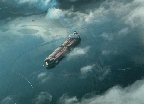
On July 30, 1989, four months after it ran aground in Alaska’s Prince William Sound and caused the then-largest oil spill in U.S. waters, the crippled Exxon Valdez entered dry dock at National Steel and Shipbuilding in San Diego—its original birthplace.

The trip south from Prince William Sound had not been without incident. Divers discovered hull plates hanging from the frame 70 feet below the surface that had to be cut away, and a 10 mile oil slick trailing behind the ship for a time prevented it from entering San Diego Bay.

New Law, New Name

Nearly a year and $30 million later, the ship emerged for sea trials as the Exxon Mediterranean. The Exxon Valdez had suffered the ignominy—and corporate hardship—of effectively being singled out in U.S. legislation (the Oil Pollution Act of 1990 [PDF]) and banned from a specific U.S. body of water:

SEC. 5007.
LIMITATION. Notwithstanding any other law, tank vessels that have spilled more than 1,000,000 gallons of oil into the marine environment after March 22, 1989, are prohibited from operating on the navigable waters of Prince William Sound, Alaska.
(33 U.S.C. § 2737)

With this banishment institutionalized in U.S. law, Exxon Shipping Company shifted the operational area for the ship to the Mediterranean and the Middle East and renamed it accordingly. In 1993, Exxon spun off its shipping arm to a subsidiary, Sea River Maritime, Inc., and the Exxon Mediterranean became the Sea River Mediterranean. This was shortened to S/R Mediterranean.

In 2002, the ship was re-assigned to Asian routes and then temporarily mothballed in an undisclosed location.

A Ship Singled Out?

Exxon filed suit in federal court challenging the provisions of the Oil Pollution Act of 1990 that had banned its tanker from the Prince William Sound trade route. In November 2002, the Ninth Circuit Court of Appeals upheld the Oil Pollution Act and its vessel prohibition provision (the Justice Department noting that to that time, 18 vessels had been prevented from entering Prince William Sound). While Sea River had argued that the law unfairly singled out and punished its tanker, and that there was no reason to believe that a tanker guilty of spilling in the past would spill in the future, the three-judge panel disagreed unanimously.

The Oil Pollution Act of 1990, the landmark law resulting from the Exxon Valdez oil spill, legislated the phase-out of all single-hulled tankers from U.S. waters by 2015. On October 21, 2003, single-hulled tankers carrying heavy oils were banned by the European Union. A complete ban on single-hulled tankers was to be phased in on an accelerated schedule in 2005 and 2010. There remains pressure to eliminate single-hulled tankers from the oil trade worldwide, so their days are clearly numbered.

In 2005, the S/R Mediterranean was reflagged under the Marshall Islands after having remained a U.S.-flagged ship for 20 years (reportedly in the hopes that it eventually would have been permitted to re-enter the Alaska – U.S. West Coast – Panama route for which it had been designed). The ship's name became simply Mediterranean.

In 2008, ExxonMobil and its infamous tanker finally parted ways when Sea River sold the Mediterranean to a Hong Kong-based shipping company, Hong Kong Bloom Shipping Co., Ltd. The ship was once again renamed, to Dong Fang Ocean, and reflagged under Panamanian registry. Its days as a tanker also came to an end, as the Dong Fang Ocean was converted into a bulk ore carrier at Guangzhou CSSC-Oceanline-GWS Marine Engineering Co., Ltd., China.

The Dong Fang Ocean labored in relative anonymity in its new incarnation until November 29, 2010. On that day, it collided with another bulk carrier, the Aali in the Yellow Sea off Chengshan, China. Both vessels were severely damaged; the Dong Fang Ocean lost both anchors, and the Aali sustained damage to its ballast tanks. The Dong Fang Ocean moved to the port of Longyan with assistance by tugs.

The End Is Near

With this last misfortune, the final countdown to oblivion began in earnest for the vessel-formerly-known-as-Exxon Valdez. In March 2011, the ship was sold for scrap to a U.S.-based company called Global Marketing Systems (GMS). GMS in turn re-sold it to the Chinese-owned Best Oasis, Ltd., for $16 million.

Ship being dismantled on a beach in India.
Exxon Valdez/Exxon Mediterranean/Sea River Mediterranean/S/R Mediterranean/Mediterranean/Dong Fang Ocean/Oriental Nicety being dismantled in Alang, India, 2012. Photo by ToxicsWatch Alliance.

Intending to bring the Oriental Nicety, as it had been renamed yet one last time, ashore at the infamous shipbreaking beaches of Alang, Gujarat, India, Best Oasis was blocked by a petition filed by Delhi-based ToxicsWatch Alliance with the Indian Supreme Court on the grounds that the ship could be contaminated with asbestos and PCBs. ToxicsWatch Alliance invoked the Basel Convention, which restricts the transboundary movements of hazardous wastes for disposal. However, an environmental audit required by the court showed no significant contamination, and in July 2012, the Oriental Nicety was cleared to be brought ashore for its final disposition. The ship was reportedly beached on August 2, 2012. Shanta Barley, writing for Nature, penned a wry obituary as a lead-in to her article about the last days of the ship:

The Oriental Nicety (née Exxon Valdez), born in 1986 in San Diego, California, has died after a long struggle with bad publicity.

Use Twitter to chat directly with NOAA marine biologist Gary Shigenaka about the Exxon Valdez and its impacts on Alaska's marine life and waters on Monday, March 24 at 3:00 p.m. Eastern. Follow the conversation at #ExxonValdez25 and get the details: http://response.restoration.noaa.gov/oil-and-chemical-spills/significant-incidents/exxon-valdez-oil-spill/tweetchat-25-years-exxon-valdez.html.

Close-up of ship's name Exxon Valdez.
The last days of the Exxon Valdez: in the San Diego shipyard before the first name change. Photo from the collection of Gary Shigenaka, NOAA.
Ship Exxon Mediterranean in waters off Trieste, Italy.
Exxon Mediterranean in Trieste, Italy, July 1991. Photo by Arki Wagner, used with permission.
Node Weight: 
10

NOAA and Private Industry Share Data to Improve Our Understanding of the Arctic

Short title: 
NOAA and Private Industry Share Data to Improve Our Understanding of the Arctic

The Rules of Sharing

We recognize that no single agency or organization has enough resources to do this alone. We have to collaborate our research efforts and share data with others working in the Arctic. An innovative agreement between NOAA and industry [PDF] was signed in August 2011 to help identify and pursue data needs in the Arctic. This agreement between NOAA, Shell, ConocoPhilips, and Stat Oil sets up a framework for sharing Arctic data in five areas:

  • meteorology.
  • coastal and ocean currents, circulation, and waves.
  • sea ice studies.
  • biological science.
  • hydrographic services and mapping.

Before we incorporate this data into NOAA products and services, we will conduct stringent quality control on all data provided to us under this agreement. Having access to additional high-quality data will improve NOAA’s ability to monitor climate change and provide useful products and services that inform responsible energy exploration activities in the region. We are committed to openness and transparency in our science. In addition to reviews to ensure the quality of the data that we receive, NOAA will make the data obtained under this agreement available to the public. Exactly what data is shared and how it is shared is laid out in a series of annexes to the overarching agreement. NOAA and the three companies have identified the need for at least three annexes. The first [PDF] and second [PDF] are complete. The third, which covers hydrographic services and mapping, is being drafted now.

Why Sharing (Data) Is Caring

View of sea ice cover from a plane.
Sea ice studies are one of the five areas of data which NOAA and industry partners will be sharing. (NOAA)

This collaboration will leverage NOAA's scientific expertise and these companies' significant offshore experience, science initiatives, and expertise. By establishing this data-sharing agreement and the associated annex agreements, NOAA is better equipped to protect the Arctic's fragile ecosystem. We will be providing the public—including energy companies, mariners, native communities, fishers, and other government agencies—with a stronger scientific foundation, which we believe will better support decision making and safe economic opportunities in this rapidly changing area. NOAA envisions an Arctic where decisions and actions related to conservation, management, and resource use are based on sound science and support healthy, productive, and resilient communities and ecosystems. We are working hard, in an era of shrinking budgets, to make sure that we are good stewards of the natural resources found in the Arctic. We will hold our industry partners to our high standards, and make sure that as we learn more, we also prepare for and minimize the risks involved in Arctic oil and gas development and increased maritime transportation. We look forward to working with these industry partners to implement this data-sharing agreement. This agreement is the type of innovative partnership we'd like to build with other entities willing to share data and work with us—leveraging the best of what we each can bring to the table. Learn more about the work NOAA’s Office of Response and Restoration is doing in the Arctic.

The snowy horizon outside Barrow, Alaska, at sunset.
Ongoing and accelerated changes in the Arctic, including the seasonal loss of sea ice and opening up of the Arctic for navigation and commerce, are creating new opportunities for transportation and resource extraction along with a new venue for accidents, spills, and other environmental hazards. Although the Arctic is warming, it will remain a remote and challenging place to work. (NOAA)
People load a propeller plane while a person approaches on snowmobile.
Travel in the Alaskan Arctic is often by small plane or snowmobile. Accessing the areas we need for research can be difficult and costly. (NOAA)
Node Weight: 
9

What Are Kids Reading About Oil Spills?

Short title: 
What Are Kids Reading About Oil Spills?

An Oil Spill Ecologist Dives into Kids' Books

So far, the eight or so books Mearns has looked at focus on one of the two major oil spills in the American mind: the 1989 Exxon Valdez oil spill in Alaska or the 2010 Deepwater Horizon spill in the Gulf of Mexico. A number are heart-warming stories about wildlife speaking about their experience in oil and the nice people who captured, cleaned, and released them. Birds, especially pelicans, and sea otters often play a starring role in telling these stories. Several present case histories of the oil spills, their causes, and cleanup. Some books place oil spills in the context of our heavy reliance on oil, but many ignore why there's so much oil being transported in the first place. One book's color drawings show oil spill cleanup methods so well you can actually see how they work—and which Mearns thinks could even be used in trainings on oil spill science. Something that may not be top-of-mind for many parents but which he appreciates is the presence of glossaries, indices, and citations for further reading. These resources can help adults and kids evaluate whether statements about these oil spills are supported by reliable information or not.

Reading Recommendations

When reading a book—whether it is about oil spills or not—with kids you know, keep the following recommendations in mind:

  • Make sure the story informs, as well as entertains.
  • Ask where the "facts" in the story came from.
  • Look for reputable, original sources of information.
  • Ask why different sources might be motivated to show information the way they do.
  • Talk to kids about thinking critically about where information comes from.

Learn more about the ocean, pollution, and creatures that live there from our list of resources for teachers and students. Photo: Carolien Dekeersmaeker/Creative Commons Attribution-NonCommercial 2.0 Generic License

Kids reading books in a book store.
Credit: Carolien Dekeersmaeker/Creative Commons Attribution-NonCommercial 2.0 Generic License
Node Weight: 
3

Looking Back: What Led up to the Exxon Valdez Oil Spill?

Short title: 
Looking Back: What Led up to the Exxon Valdez Oil Spill?
March 1989 calendar image of Exxon Valdez ship.
In an ironic twist of fate, the Exxon Shipping Company's safety calendar featured the T/V Exxon Valdez in March 1989. Image: From the collection of Gary Shigenaka.
Calendar for March 1989 with image of Exxon Valdez ship.
A full view of the Exxon Shipping Company's safety calendar, which featured the Exxon Valdez the same month the ship ran aground, in March 1989. Image: From the collection of Gary Shigenaka.
Node Weight: 
8

After an Oil Spill, Why Does NOAA Count Recreational Fishing Trips People Never Take?

Short title: 
After an Oil Spill, Why Does NOAA Count Recreational Fishing Trips People Never Take?

Restoring Nature’s Benefits to People

After a spill, these public lands, waters, and wildlife become cut off from people. At NOAA, we have the responsibility to make sure those lost trips to the beach for fishing or swimming are documented—and made up for—along with the oil spill's direct harm to nature. Why do we collect the number of fishing trips or days of swimming that don't occur during a spill? It's simple. Our job is to work with the organization or person responsible for the oil spill to make sure projects are completed that compensate the public for the time during the spill they could not enjoy nature's benefits. If people did not fish recreationally in the wake of a spill because a fishery was closed or inaccessible, opportunities for them to fish after the spill need to be increased. These opportunities may come in the form of building more boat ramps or new public access points to the water. Working with our partners, NOAA develops restoration plans that recommend possible projects that increase opportunities for and public access to activities such as fishing, swimming, or hiking. We then seek public input to make sure these projects are supported by the affected community. The funding for these finalized restoration projects comes from those responsible for the spill.

What Does This Look Like in Practice?

On April 7, 2000, a leak was detected in a 12-inch underground pipeline that supplies oil to the Potomac Electric Power Company's (PEPCO) Chalk Point generating station in Aquasco, Md. Approximately 140,000 gallons of fuel oil leaked into Swanson Creek, a small tributary of the Patuxent River. About 40 miles of vulnerable downstream creeks and shorelines were coated in oil as a result. We and our partners at the State of Maryland assessed the impacts to recreational fishing, boating, and shoreline use (such as swimming, picnicking, and wildlife viewing). We found that 10 acres of beaches were lightly, moderately, or heavily oiled and 125,000 trips on the river were affected. In order to compensate the public for these lost days of enjoying the river, we worked with our partners to implement the following projects:

  • Two new canoe and kayak paddle-in campsites on the Patuxent River.
  • Boat ramp and fishing pier improvements at Forest Landing.
  • Boat launch improvements to an existing fishing pier at Nan's Cove.
  • Recreational improvements at Maxwell Hall Natural Resource Management Area.
  • An Americans with Disabilities Act (ADA)-accessible kayak and canoe launch at Greenwell State Park.

For more detail, you can learn how NOAA economists count and calculate the amount of restoration needed after pollution is released and also watch a short video lesson in economics and value from NOAA's National Ocean Service.

Families fishing off of a seawall.
A perhaps less obvious impact of an oil spill is that people become unable to enjoy the benefits of the affected natural areas. For example, this could be recreational fishing, boating, swimming, or hiking. (NOAA)
Node Weight: 
2

A Pennsylvania Town Moves Beyond Toxic History of Denuded Mountains and Contaminated Creeks

Short title: 
A Pennsylvania Town Moves Beyond Toxic History of Denuded Mountains and Contaminated Creeks

MARCH 3, 2014 — Palmerton, a small town in eastern Pennsylvania's coal region, had its beginnings largely as a company town. In fact, it was incorporated in 1912 around the area's growing zinc mining industry, which began in 1898. For many years, the New Jersey Zinc Company was the largest U.S. producer of zinc, which is used to make brass and construction materials. The town actually was named after Stephen Palmer, once head of the company. But this company left more than just a name imprinted on this part of Pennsylvania. It also left a toxic legacy on the people and the landscape. The backdrop for this industrial town of just under 5,500 people is Blue Mountain, which the Appalachian Trail runs through, and Aquashicola Creek, which drains into the Lehigh River, used extensively for transporting the region's coal and a tributary of the Delaware River.

As a result of the industrial activities that took place in Palmerton for more than 80 years, the town was left with an enormous smelting residue pile called the "Cinder Bank." The Cinder Bank is what is left of the 33 million tons of slag (rocky waste) left by the New Jersey Zinc Company as a byproduct of their mining operations. According to the U.S. Environmental Protection Agency (EPA), this pile extends for 2.5 miles and is over 100 feet high and 500 to 1000 feet wide. In addition, the smelting operations, a high-heat process that extracts metals from ore, released heavy metals, including cadmium, lead, and zinc, into the air and waters of the surrounding area.

These activities killed off vegetation on 2,000 acres of Blue Mountain and allowed contaminants to flow into the Aquashicola Creek and Lehigh River. According to the EPA, children in this area tested over the years showed elevated levels of lead in their blood. Horses, cattle, and fish were also shown to contain contaminants. Because of a declining market for zinc and increased attention to hazards of environmental contamination, zinc smelting in Palmerton stopped in 1980. The Palmerton site was added to the Superfund National Priorities List on September 8, 1983. Cleanup of the town, Blue Mountain, and the Cinder Bank, overseen by U.S. EPA Region 3, has been going on since 1987. It has included activities such as grading, revegetation, cleaning of residences, cleanup of surface water, and water treatment.

Groups of people standing by a state game lands sign in front of woods.
In August 2013, the Natural Resource Trustee Council members and guests celebrated the acquisition of more than 300 acres for state game lands and the Cherry Valley National Wildlife Refuge. (NOAA)

NOAA and other federal and state agencies, comprising the natural resource trustee council for this Superfund site, reached a settlement for damages to natural resources in 2009. Over $20 million in cash and property have been paid to compensate the United States and the Commonwealth of Pennsylvania for the natural resource damages to the Aquashicola Creek and Lehigh River watershed. Throughout this process, NOAA Office of Response and Restoration's Peter Knight and the National Marine Fisheries Services' John Catena have been providing scientific review and input on the environmental cleanup and restoration plans for this site.

In August of 2013, the Palmerton Natural Resource Trustee Council and its partners announced the acquisition of more than 300 acres for state game lands and the Cherry Valley National Wildlife Refuge, home to the endangered bog turtle, and located just 30 minutes from Palmerton. Other properties designated for restoration include habitats along Aquashicola Creek and its tributaries. Acquiring and protecting these lands and waters are part of the larger restorative effort making up for the loss of both natural areas and their benefits due to Palmerton's mining activities. After many years of collaboration by a number of organizations and individuals, today the Lehigh River is popular with rafters and Blue Mountain is home to a lush 750 acre nature preserve and a 12 lift ski resort. According to its Chamber of Commerce, Palmerton is again a growing town and making incredible progress in moving beyond the once-tainted shadow of its history.

Greek Catholic Church and a road through a Pennsylvania forest.
Left, Saints Peter & Paul Greek Catholic Church in Palmerton. During New Jersey Zinc’s most productive years, many of the workers that settled in town came from Eastern Europe. The company designed the layout of the town to accommodate the growing population and is credited for its regular grid. (Michael Thompson/Creative Commons Attribution-NonCommercial-NoDerivs 2.0 Generic License) Right, outside of Palmerton, Fireline Road winds through a wooded landscape that is home to over 50 species of birds. (Andrew Wertz/Creative Commons Attribution-NonCommercial-NoDerivs 2.0 Generic License)

Agencies represented by the Palmerton Natural Resource Trustee Council include the U.S. Fish and Wildlife Service, National Park Service, National Oceanic and Atmospheric Administration (NOAA), Pennsylvania Game Commission, Pennsylvania Fish and Boat Commission, Pennsylvania Department of Environmental Protection, and the Pennsylvania Department of Conservation and Natural Resources. The Office of Response and Restoration represents NOAA on this council.

Abandoned zinc mining factory in Palmerton, Pennsylvania.
One of the New Jersey Zinc Company's abandoned factories, located on the west side of the site in Palmerton, Penn. (Dennis Hendricks/Creative Commons Attribution-NonCommercial 2.0 Generic License)
Lehigh River runs between a mountain and ridge with Palmerton in the background.
Palmerton and the former zinc smelters are located near the Lehigh River, which flows through a valley between Blue Mountain (left) and Stony Ridge. (Christine McAndrew/Creative Commons Attribution-NonCommercial-NoDerivs 2.0 Generic License)
Node Weight: 
2

Mapping the Problem After Owners Abandon Ship

Short title: 
Mapping the Problem After Owners Abandon Ship

FEBRUARY 26, 2014 -- One of the largest vessel removal efforts in Washington history was a former Navy Liberty Ship, the Davy Crockett.

In 2011 the Davy Crockett, previously abandoned by its owner on the Washington shore of the Columbia River, began leaking oil and sinking due to improper and unpermitted salvage operations.

Its cleanup and removal cost $22 million dollars, and the owner was fined $405,000 by the Washington Department of Ecology and sentenced to four months in jail by the U.S. Attorney, Western District of Washington.

As we have mentioned before, derelict and abandoned vessels like the Davy Crockett are a nationwide problem that is expensive to deal with properly and, if the vessels are left to deteriorate, can cause significant environmental impacts.

Unfortunately Washington's Puget Sound is no exception to this issue.

Agency Collaboration

The NOAA Office of Response and Restoration's LTJG Alice Drury is part of the Derelict Vessel Task Force led by U.S. Coast Guard Sector Puget Sound. Made up of federal, state, and local agencies, this task force aims to identify and remove imminent pollution and hazard-to-navigation threats from derelict vessels and barges within Puget Sound. Among these agencies there are different jurisdictions and enforcement mechanisms related to derelict vessels.

A key player is Washington's Department of Natural Resources (WA DNR), which manages the state Derelict Vessel Removal Program (DVRP). The DVRP has limited funding for removal of priority vessels. Unfortunately, according to WA DNR [PDF], with the growing number and size of problem vessels, program funding can’t keep up with the rising removal and disposal costs. The backlog of vessels in need of removal continues to grow.

Keeping Track

LTJG Drury is working with the NOAA Office of Response and Restoration's Spatial Data Branch to enter this list of derelict vessels into ERMA®. ERMA is a NOAA online mapping tool that integrates both static and real-time data to support environmental planning and response operations. Right now the vessels are primarily tracked in the WA DNR DVRP database. By pulling this data into ERMA, the task force will not only be able to see the vessels displayed on a map but also make use of the various layers of environmental sensitivity data already within ERMA. The hope is that this can help with the prioritizing process and possibly eventually be used as a tool to raise awareness.

Screen capture view of Pacific Northwest ERMA showing a map of Puget Sound with ports and shoreline sensitivity indicated in various colors.
A view of Pacific Northwest ERMA, a NOAA online mapping tool which can bring together a variety of environmental and response data. Here, you can see the black dots where ports are located around Washington's Puget Sound as well as the colors indicating the shoreline's characteristics and vulnerability to oil. (NOAA)

However, there aren't enough resources within the Derelict Vessel Task Force to gather and continue to track (as the vessels can move) all the data needed in order to map the vessels accurately in ERMA. As a result, the task force is turning to local partners in order to help capture data.

Reaching Out

One such partner is the local Coast Guard Auxiliary Flotillas, a group of dedicated civilians helping the Coast Guard promote safety and security for citizens, ports, and waterways. In order to garner support for data-gathering, she recently attended the USCG Auxiliary Flotilla Seattle-Elliott Bay meeting, along with members of the local Coast Guard Incident Management Division who head the Puget Sound Derelict Vessel Task Force.

LTJG Drury spoke about a few local derelict vessel incidents and their impacts to the environment. She also showed how ERMA can be a powerful tool for displaying and prioritizing this information—if we can get the basic data that’s missing. As a result, this Flotilla will follow up with the Coast Guard and start collecting missing information on derelict and abandoned vessels on behalf of the Coast Guard and WA DNR.

Gathering data and displaying derelict vessels graphically is a small, but important, step on the way to solving the massive problem of derelict vessels. Once complete we hope that ERMA will be a powerful aid in displaying the issue and helping make decisions regarding derelict vessels in the Puget Sound. Stay tuned.

You can see a U.S. Coast Guard video of the start-to-finish process of removing the Davy Crockett from the Columbia River along with the Washington Department of Ecology's photos documenting the response.

A piece of the vessel Davy Crockett is lifted out of the water during salvage.
On July 7, 2011, part of one of the cargo holds of the derelict vessel (but one-time Navy Liberty Ship) Davy Crockett is lifted from the waters of the Columbia River. (Washington Department of Ecology)
A worker removing oiled sorbent material from inside the cofferdam around ship
A worker removing oiled sorbent material from inside the cofferdam that surrounded the Davy Crockett during the ship's salvage and removal. September 13, 2011. (Washington Department of Ecology)
Node Weight: 
2

"Gyre: The Plastic Ocean" Exhibit Puts Ocean Trash on Display in Alaska

Short title: 
"Gyre: The Plastic Ocean" Exhibit Puts Ocean Trash on Display in Alaska
Neon sign with the word GYRE.
Gyre: The Plastic Ocean exhibition runs Feb. 7 through Sept. 6, 2014 at the Anchorage Museum at Rasmuson Center. (NOAA)
A pack of dogs leading a sled made entirely of trash.
A pack of dogs leading a sled made entirely from recycled materials gathered from the Los Angeles area by artist Cynthia Minet. The dogs are made principally from laundry detergent bottles and other plastics found in dumpsters, and the sled was made from a rowboat that was put out on the curb for pick up on trash day. (NOAA) Correction: This post originally stated that this exhibit was made from marine debris.
Node Weight: 
3

What Restoration Is in Store for Massachusetts and Rhode Island after 2003 Bouchard Barge 120 Oil Spill?

Short title: 
What Restoration Is in Store for Massachusetts and Rhode Island after 2003 Bouchard Barge 120 Oil Spill?

FEBRUARY 18, 2014 -- The Natural Resource Damages Trustee Council for the Bouchard Barge 120 oil spill have released a draft restoration plan (RP) and environmental assessment (EA) [PDF] for shoreline, aquatic, and recreational use resources impacted by the 2003 spill in Massachusetts and Rhode Island. It is the second of three anticipated plans to restore natural resources injured and uses affected by the 98,000-gallon spill that oiled roughly 100 miles of shoreline in Buzzards Bay. A $6 million natural resource damages settlement with the Bouchard Transportation Co., Inc. is funding development and implementation of restoration, with $4,827,393 awarded to restore shoreline and aquatic resources and lost recreational uses. The draft plan evaluates alternatives to restore resources in the following categories of injuries resulting from the spill:

  • Shoreline resources, including tidal marshes, sand beaches, rocky coast, and gravel and boulder shorelines;
  • Aquatic resources, including benthic organisms such as American lobster, bivalves, and their habitats, and finfish such as river herring and their habitats; and
  • Lost uses, including public coastal access, recreational shell-fishing, and recreational boating.

The plan considers various alternatives to restore these resources and recommends funding for more than 20 projects throughout Buzzards Bay in Massachusetts and Rhode Island. Shoreline and aquatic habitats are proposed to be restored at Round Hill Marsh and Allens Pond Marsh in Dartmouth, as well as in the Weweantic River in Wareham. Populations of shellfish, including quahog, bay scallop, and oyster will be enhanced through transplanting and seeding programs in numerous towns in both states. These shellfish restoration areas will be managed to improve recreational shell-fishing opportunities. Public access opportunities will be created through a variety of projects, including trail improvements at several coastal parks, amenities for universal access, a handicapped accessible fishing platform in Fairhaven, Mass., and acquisition of additional land to increase the Nasketucket Bay State Reservation in Fairhaven and Mattapoisett. New and improved public boat ramps are proposed for Clarks Cove in Dartmouth and for Onset Harbor in Wareham.

An oiled loon on Horseneck Beach.
An oiled loon on Horseneck Beach. Approximately 450 birds were immediately killed by the oil spill, including loons, scoters, mergansers, oyster catchers, terns, common eiders, and piping plovers. (NOAA)

The draft plan also identifies Tier 2 preferred projects; these are projects that may be funded, if settlement funds remain following the selection and implementation of Tier 1 and/or other restoration projects that will be identified in the Final RP/EA to be prepared and released by the Trustee Council following receipt and consideration of input from the public. "We continue to make progress, together with our federal and state partners, in restoring this bay and estuary where I have spent so much of my life," said John Bullard, National Oceanic and Atmospheric Administration (NOAA) Fisheries Northeast Regional administrator. "And, we're eager to hear what members of the public think of the ideas in this plan, which are intended to further this work. We hope to improve habitats like salt marshes and eelgrass beds in the bay. These will benefit river herring, shellfish and other species and support recreational activities for the thousands of people who use the bay." The public is invited to review the Draft RP/EA and submit comments during a 45-day period, extending through Sunday, March 23, 2014. The electronic version of this Draft RP/EA document is available for public review at the following website: http://www.darrp.noaa.gov/northeast/buzzard/index.html Comments on the Draft RP/EA should be submitted in writing to: NOAA Restoration Center Attention: Buzzards Bay RP/EA Review Coordinator 28 Tarzwell Drive Narragansett, R.I. 02882 BuzzardsBay.RP.EA.Review@noaa.gov

A map of the preferred restoration projects in Massachusetts and Rhode Island for the Bouchard Barge 120 spill, as identified in the second draft restoration plan.
A map of the preferred restoration projects for the Bouchard Barge 120 spill, as identified in the second draft restoration plan. (NOAA)
A large barge is being offloaded next to tugboats in the ocean.
On April 27, 2003, Bouchard Barge 120 was being offloaded after initial impact with a submerged object, causing 98,000 gallons of oil to spill into Massachusett's Buzzards Bay. (NOAA)
Top: People point at shellfish on wood. Bottom: Closed beach sign with boat.
Top, Quahog shellfish collected for tissue analysis after the spill of 98,000 gallons of oil contaminated the waters of Massachusetts’ Buzzards Bay in 2003. Bottom, immediately following the spill, signs were posted on beaches advising the public of the ban on shellfishing due to oil contamination. The restoration plan intends to make up for the public's inability to use these resources. (NOAA)
Node Weight: 
4

Happy Valentine's Day from NOAA

Short title: 
Happy Valentine's Day from NOAA

FEBRUARY 14, 2014 -- At NOAA, we put our heart into our work every day of the year—whether we're cleaning up marine debris from beaches or modeling the (at times) curiously shaped paths of spilled oil. But on some days, we take this a little more literally than others. As you can see in the video below, our oceanographers have used the NOAA oil spill forecast model GNOME to show what it looks like when they put their heart into their work for Valentine's Day. Perhaps this hypothetical scenario might be what we should expect if a shipment of candy hearts were to spill off the coast of Washington? Happy Valentine's Day from NOAA!

Man near the ocean with trash bag pointing to wooden heart enscribed with love.
NOAA's Nir Barnea, Marine Debris West Coast Regional Coordinator, finds a bit of marine debris "love" at the 2007 International Coastal Cleanup held in Seattle, Wash. (NOAA)
Node Weight: 
1

Pages

Subscribe to response.restoration.noaa.gov RSS