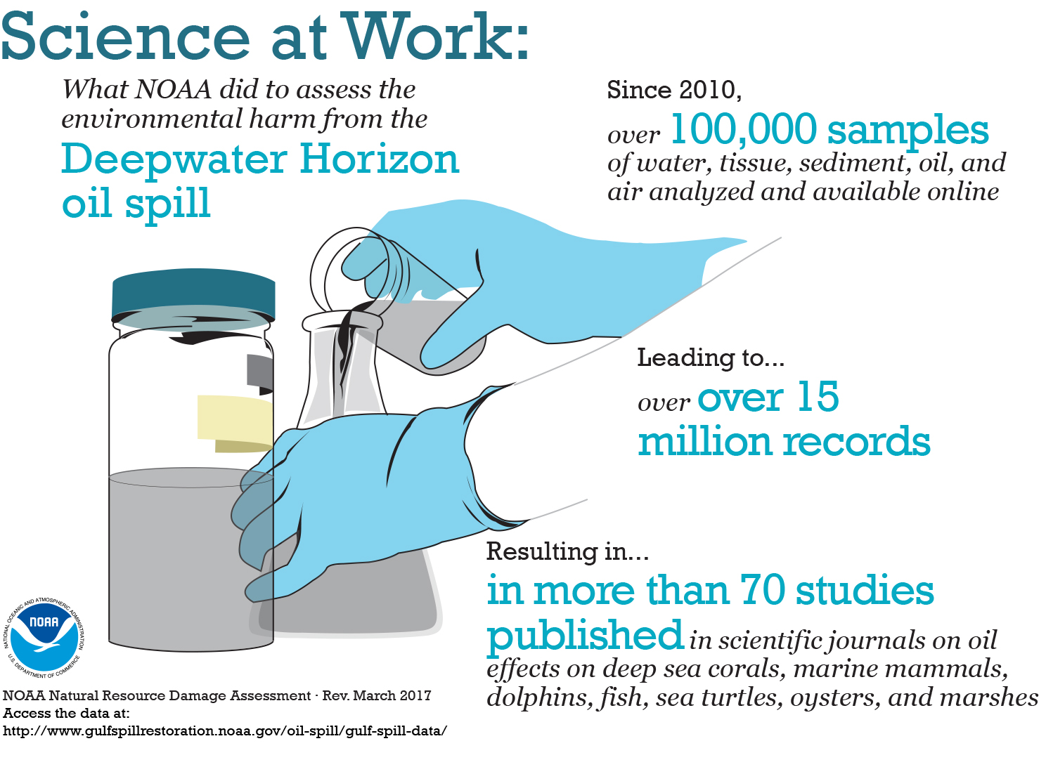
NOAA and Partners Work Quickly to Save Corals Hit by Catamaran in Puerto Rico
An official website of the United States government. Here's how you know we're official.
A .gov website belongs to an official government organization in the United States.
A small lock or https:// means you’ve safely connected to a .gov website. Share sensitive information only on official, secure websites.
POSTED MAY 20, 2015 | UPDATED MAY 21, 2015 -- On May 19, 2015, NOAA was notified of a 24-inch pipeline rupture that occurred earlier in the day near Refugio State Beach in Santa Barbara County, California.
A reported 500 barrels (21,000 gallons) of crude oil flowed from the shore side of Highway 101 into the Pacific Ocean. The source has since been secured.
As of May 21, Office of Response and Restoration oceanographers estimate that forecasted winds and currents in the affected area of the oil spill will move the slick eastward parallel to the shore Thursday night and Friday. The oil consists of patches and streaks of various sizes and thicknesses, broken up and spread over approximately 20 miles of coast and up to 5 miles offshore. The percent of oil floating on the surface in the slicks is low, estimated to be less than 10 percent in the affected area.
Cleanup measures include skimmers, vacuum trucks, absorbent pads, and absorbent boom. Shoreline Cleanup Assessment Technique (SCAT) teams are documenting the level of oil and impacts to the shoreline. 7,777 gallons of an oil and water mixture have been collected from the ocean. Several oiled birds, including pelicans, and an oiled California sea lion were found stranded and are being taken care of by official wildlife rehabilitation teams.
According to the U.S. Coast Guard, a commercial oil spill response company is conducting cleanup operations. Boats are collecting oil offshore. California Department of Fish and Wildlife has ordered beach closures. The U.S. Coast Guard has organized the Incident Management Team and is conducting overflights. The U.S. Environmental Protection Agency is also responding and is focusing on the site of the pipeline break and inland cleanup.
The Office of Response and Restoration's Jordan Stout is on-scene as the NOAA Scientific Support Coordinator as well as an OR&R overflight observation specialist. OR&R has been providing information on fate and effects of the crude oil and potential environmental impacts both in the water and on the shore.
In this preassessment phase scientists are researching what resources may have been exposed to the oil and whether to proceed with a Natural Resource Damage Assessment. Additional scientists will be deployed to the area in the coming days. Also from NOAA, the National Weather Service, the National Marine Fisheries Service, the Restoration Center, and the Office of National Marine Sanctuaries are providing support.
In 1969, a major oil spill occurred in the Santa Barbara area as a result of a well blowout. One of the largest environmental disasters in U.S. waters at that time, the legacy of that incident includes the creation of the National Environmental Policy Act, U.S. Environmental Protection Agency, and National Marine Sanctuaries system (which soon encompassed California’s nearby Channel Islands, which were affected by the 1969 Santa Barbara spill).
For further information, see the Joint Information Center website: Refugio Response Information.
MAY 20, 2015 — What has been causing the alarming increase in dead bottlenose dolphins along the northern Gulf of Mexico since the Deepwater Horizon oil spill in the summer of 2010? Independent and government scientists have found even more evidence connecting these deaths to the same signs of illness found in animals exposed to petroleum products, as reported in the peer-reviewed online journal PLOS ONE. This latest study uncovered that an unusually high number of dead Gulf dolphins had what are normally rare lesions on their lungs and hormone-producing adrenal glands. The timing, location, and nature of the lesions support that oil compounds from the Deepwater Horizon oil spill caused these lesions and contributed to the high numbers of dolphin deaths within this oil spill’s footprint.
"This is the latest in a series of peer-reviewed scientific studies, conducted over the five years since the spill, looking at possible reasons for the historically high number of dolphin deaths that have occurred within the footprint of the Deepwater Horizon spill," said Dr. Teri Rowles, one of 22 contributing authors on the paper, and head of NOAA's Marine Mammal Health and Stranding Response Program, which is charged with determining the causes of unusual mortality events. "These studies have increasingly pointed to the presence of petroleum hydrocarbons as being the most significant cause of the illnesses and deaths plaguing the Gulf's dolphin population," said Dr. Rowles.
In this study, one in every three dead dolphins examined across Louisiana, Mississippi and Alabama had lesions affecting their adrenal glands, resulting in a serious condition known as "adrenal insufficiency." The adrenal gland produces hormones—such as cortisol and aldosterone—that regulate metabolism, blood pressure and other bodily functions. "Animals with adrenal insufficiency are less able to cope with additional stressors in their everyday lives," said Dr. Stephanie Venn-Watson, the study's lead author and veterinary epidemiologist at the National Marine Mammal Foundation, "and when those stressors occur, they are more likely to die." Earlier studies of Gulf dolphins in areas heavily affected by the Deepwater Horizon oil spill found initial signs of this illness in a 2011 health assessment of dolphins living in Barataria Bay, Louisiana.
NOAA scientists Dr. Rowles and Dr. Lori Schwacke spoke about the results of this health assessment in a 2013 interview: "One rather unusual condition that we noted in many of the Barataria Bay dolphins was that they had very low levels of some hormones (specifically, cortisol) that are produced by the adrenal gland and are important for a normal stress response. Under a stressful condition, such as being chased by a predator, the adrenal gland produces cortisol, which then triggers a number of physiological responses including an increased heart rate and increased blood sugar. This gives an animal the energy burst that it needs to respond appropriately. In the Barataria Bay dolphins, cortisol levels were unusually low. The concern is that their adrenal glands were incapable of producing appropriate levels of cortisol, and this could ultimately lead to a number of complications and in some situations even death."
In addition to the lesions on adrenal glands, the scientific team discovered that more than one in five dolphins that died within the Deepwater Horizon oil spill footprint had a primary bacterial pneumonia. Many of these cases were unusual in severity, and caused or contributed to death.
Drs. Rowles and Schwacke previously had observed significant problems in the lungs of dolphins living in Barataria Bay. Again, in 2013, they had noted, "In some of the animals, the lung disease was so severe that we considered it life-threatening for that individual." In other mammals, exposure to petroleum-based polycyclic aromatic hydrocarbons, known as PAHs, through inhalation or aspiration of oil products can lead to injured lungs and altered immune function, both of which can increase an animal's susceptibility to primary bacterial pneumonia. Dolphins are particularly susceptible to inhalation effects due to their large lungs, deep breaths, and extended breath hold times. Learn more about NOAA research documenting the impacts from the Deepwater Horizon oil spill and find more stories reflecting on the five years since this oil spill.
The Caffee Road Landfill at the base's Site 11 was such a mix of soil, waste, and debris that it actually extended the shoreline up to 150 feet into Mattawoman Creek. In addition to serving as a landfill for Indian Head, the military used the site to burn waste, and munitions and explosives potentially lay buried in pockets along the shoreline. Getting this landfill—an ongoing source of pollution—under control needed to accomplish three goals: block contact with the contaminated soil, prevent shoreline erosion, and avoid exposing potential ordnance. The design for remediating this site included placing a protective soil cover over the landfill and stabilizing the shoreline. Historically, shoreline stabilization has been achieved by positioning large rocks and riprap on the edge of the water, which "hardens" the shoreline and would move the wave energy from the protected area to adjacent areas. Instead, NOAA and the trustee agencies responsible for the area's natural resources proposed what is called a "living shoreline." These hybrid shorelines are constructed habitats designed to mimic the functions of natural shoreline habitats and which incorporate both natural habitat and built infrastructure. They aim to provide the same benefits as nature, such as shoreline stabilization, improved water quality, and wildlife habitat. The project was rounded out by planting marsh shrubs and trees along the shoreline and by seeding and mulching the soil cover on top of the landfill. All the while during these construction operations, the cleanup team had a trained professional clearing the munitions and explosives to provide safe working conditions as they transformed this dump into a safe place for fish, birds, and wildlife.
The close partnership among several federal and state agencies, including the Navy, U.S. Environmental Protection Agency, Maryland Department of the Environment, and the trustees, was instrumental in successfully and efficiently converting this former landfill into vibrant habitat, resulting in savings of more than $700,000.
A similar transformation has occurred at a landfill on the base's Site 36. This landfill, most likely originally part of Chickamuxen Creek and a nearby wetland, was used from 1972 to 1974 and has been inactive since that time. The fill material dumped into the creek was believed to contain metal casings from mines, bombs, and torpedoes—not exactly normal working conditions. Cleanup focused on removing scrap metal and potential munitions items from the surface of the landfill and the shoreline. The multi-agency team hauled away more than 57,000 pounds of metal and other materials from the site, with much of it recycled rather than left under the existing soil cover. By taking a common-sense approach to removing this debris, the project managed risk and minimized environmental impacts by maintaining natural habitats, including forests and wetlands, whenever possible, while also ensuring the landfill’s soil cover would control pollution. While there is still work to be done, progress abounds elsewhere on the naval facility. For example, the multi-agency cleanup team removed creek sediments contaminated with mercury and surrounding floodplain soils to protect and enhance restoration of habitat along a tributary to Mattawoman Creek. The tributary has been blocked off from the main channel to prevent mercury from getting to Mattawoman Creek, but with the mercury gone, there is now potential for opening up the tributary and reconnecting it with the creek. Naval Support Facility Indian Head occupies a unique place in military history, and thanks to efficient collaboration among federal and state agencies working to clean it up, this locale again provides valuable and healthy habitat for fish, birds, and wildlife along the Chesapeake Bay.
DIVER is a data management tool initially developed for the damage assessment resulting from the Deepwater Horizon oil spill. The tool serves as a centralized data repository, which you can use to find and download diverse sets of validated environmental data from the Gulf of Mexico and the coastal U.S.
NOAA and its partner agencies often collect and maintain a large amount of data to document the location and extent of injuries to the environment. To determine impacts from an incident, samples may be taken from air, water, sediment, oil, even tissue from wildlife. Field teams may also record environmental conditions (e.g., water temperature, salinity, and oxygen levels) and visual observations (e.g., vegetation density, and wildlife counts, indicators of wildlife heath).
The DIVER (Data Integration, Visualization, Exploration, and Reporting) tool was developed by NOAA to support these natural resource damage assessment (NRDA) efforts.
The DIVER application supports integration and distribution of NRDA assessment and restoration data, as well as historical data collected from hazardous sites around the country. It allows scientists from different organizations and laboratories located across the country to upload field data, analyses, photographs, and other key information related to their environmental impact studies in a standardized format.
You can use the DIVER Explorer query tool, which allows users to search, filter, and download data. Query results are presented in an interactive dashboard, with a map, charts, table of results, metadata (data about the data), and several options for exporting data for mapping or further analysis.
NOAA Builds Tool to Hold Unprecedented Amounts of Data from Studying an Unprecedented Oil Spill: Learn the behind-the-scenes story of how a NOAA team developed DIVER to gather and organize what would become an unprecedented amount of data generated from the Deepwater Horizon oil spill.
NOAA discusses using big data techniques to make environmental datasets accessible to the public and scientific community.
Questions: Contact us with your questions, comments, or suggestions for DIVER.
MAY 4, 2015 — A flexible new data management tool—known as DIVER and developed by NOAA to support the Natural Resource Damage Assessment for the 2010 Deepwater Horizon oil spill—is now available for public use. DIVER stands for "Data Integration, Visualization, Exploration and Reporting," and it can be accessed at dwhdiver.orr.noaa.gov.
DIVER was developed as a digital data warehouse during the Deepwater Horizon oil spill response effort and related damage assessment process, which has required collecting and organizing massive amounts of scientific data on the environmental impacts of the spill. The tool serves as a centralized data repository that integrates diverse environmental data sets collected from across the Gulf of Mexico ecosystem. It allows scientists from different organizations and laboratories located across the country to upload field data, analyses, photographs, and other key information related to their studies in a standardized format. DIVER thus brings together all of that validated information into a single, web-based tool.
In addition, DIVER provides unprecedented flexibility for filtering and downloading validated data collected as part of the ongoing damage assessment efforts for the Gulf of Mexico. The custom query and mapping interface of the tool, "DIVER Explorer," provides both a data filter and review tools, which allow users to refine how they look for data and explore large data sets online. Query results are presented in an interactive dashboard, with a map, charts, table of results, metadata (data about the data), and sophisticated options for exporting the data.
In addition to the DIVER Explorer query tools, this website presents a detailed explanation of our data management approach, an explanation of field definitions and codes used in the data warehouse, and a robust help section. Currently, DIVER provides access to nearly 4 million validated results of analytical chemistry from over 50,000 samples of water, tissue, oil, and sediment collected by federal, state, academic, and nongovernmental organizations to support the Deepwater Horizon damage assessment. As additional data sets become publicly available they will be accessible through the DIVER Explorer tool. Read the announcement of this tool's public launch from the NOAA website.
APRIL 27, 2015 -- The year 2013 saw two major chemical disasters in the United States, which tragically killed 17 people and injured hundreds more.
As a result, President Obama signed Executive Order 13650 (EO 13650) August 1, 2013, followed by a report the next year to improve the safety and security of chemical facilities and to reduce the risks of hazardous chemicals to workers and communities.
As part of this directive, six federal agencies and departments, including the U.S. Environmental Protection Agency (EPA), formed a work group to investigate how to better help local communities plan for and respond to emergencies involving hazardous substances.
Out of these work group discussions came one area needing improvement which might sound surprising to the average person: data sharing.
Specifically, the work group highlighted the need to improve data sharing among the various federal programs that regulate hazardous substances and the state and local communities where those chemicals are produced, stored, and transported.
EPA works with NOAA on the chemical spill planning and response software suite known as CAMEO. These software programs offer communities critical tools for organizing and sharing precisely this type of chemical data.
Many parts of the federal government, including several of the agencies involved in the work group, regulate hazardous chemicals in a number of ways to keep our communities safe. That means collecting information from industry on the presence or usage of hazardous substances in communities across the nation. It also results in a lot of data reported on the hazardous materials manufactured, used, stored, and transported in the United States. Making sure these data are shared with the right people is a key goal for chemical safety.
However, federal agencies do not require industry to report all of this information in consistent formats across agencies. Furthermore, this reported information on hazardous chemicals is generally not available to local emergency planners and responders—the very people who would need quick access to that information during a disaster in their community.
Trying to access, collect, and share all of this information is a challenge for state and local emergency responders trying to prevent the type of chemical disasters that devastated West, Texas, and Geismar, Louisiana, in 2013. Fortunately, however, NOAA and EPA have a suite of software tools—known as CAMEO—that helps make this task a little easier.
This is the ninth and final story in a series of stories over the past month looking at various topics related to the response, the Natural Resource Damage Assessment science, restoration efforts, and the future of the Gulf of Mexico.
APRIL 22, 2015 — When the Exxon Valdez tanker ran aground in Alaska and spilled nearly 11 million gallons of crude oil in 1989, the world was a very different place.
New laws, regulations, and technologies followed that spill, meaning future oil spills—though they undoubtedly would still occur—would do so in a fundamentally different context.
This was certainly the case by 2010 when the Deepwater Horizon oil rig suffered an explosion caused by a well blowout in the Gulf of Mexico. Tankers transporting oil have become generally safer since 1989 (thanks in part to now-required double hulls), and in 2010, the new frontier in oil production—along with new risks—was located at a wellhead nearly a mile under the ocean surface.
Since that fateful April day in 2010, NOAA has responded to another 400 oil and chemical incidents. Keeping up with emerging technologies and changing energy trends helps us become better prepared for the oil spills of tomorrow, whether they stem from a derailed train carrying particularly flammable oil, a transcontinental pipeline of diluted oil sands, or a cargo ship passing through the Arctic's icy but increasingly accessible waters.
So how is NOAA's Office of Response and Restoration preparing for future oil spills?
Crude oil production from North Dakota's Bakken region has more than quadrupled [PDF] since 2010, and responders must be prepared for spills involving this lighter oil (note: not all oils are the same).
Bakken crude oil is highly flammable and evaporates quickly in the open air. Knowing the chemistry of this oil can help guide decisions about how to respond to spills of Bakken oil. As a result, we've added Bakken as one of the oil types in ADIOS, our software program which models what happens to spilled oil over time. Now, responders can predict how much oil naturally disperses, evaporates, or remains on the water's surface using information customized for Bakken's unique chemistry.

We've also been collaborating across the spill response community to boost preparedness for these types of oil spills. Earlier this year, NOAA worked with the National Response Team to teach responders about how to deal with Bakken crude oil spills, with a special emphasis on health and safety.
The increase of Bakken crude poses another challenge to the nation: spills from oil-hauling trains. There are few ways to move Bakken crude from wells in North Dakota to refiners and consumers across the country. To keep up with the demand, producers have turned to rail transport as a quick alternative. In 2010, rail moved less than five million tons of crude petroleum. By 2013, that number had jumped to nearly 40 million.
NOAA typically responds to marine spills, but our scientific experience also proves useful when oil spills into a navigable river, as can happen when a train derails. To help answer response questions for waterways at risk, we’re adding even more data to our tools for spill responders. Ongoing updates to the Environmental Response Management Application (ERMA), our online mapping tool for environmental response data, illustrate the intersection of railroads and sensitive habitats and species, which might be affected by a spill from a train carrying oil.
This is the eighth in a series of stories over the coming weeks looking at various topics related to the response, the Natural Resource Damage Assessment science, restoration efforts, and the future of the Gulf of Mexico.
APRIL 20, 2015 — Five years ago, in the middle of the response to the Deepwater Horizon oil spill, I was thrown into a scientific debate about the role of chemical dispersants in response to the spill.
Dispersants are one of those things that are talked about a lot in the context of oil spills, but in reality used pretty rarely. Over my more than 20 years in spill response, I've only been involved with a handful of oil spills that used dispersants.
But the unprecedented use of chemical dispersants on and below the ocean's surface during the Deepwater Horizon oil spill raised all sorts of scientific, public, and political questions. Questions about both their effectiveness in minimizing impacts from oil as well as their potential consequences for marine life in the Gulf of Mexico.
Did we understand how the ingredients and components of the dispersants behave? How toxic are they? What are the potential risks of dispersants and do they outweigh the benefits?
We knew the flood of questions wouldn't end when the gushing oil well was capped; they would only intensify the next time there was a significant oil spill in U.S. waters. NOAA, as the primary scientific adviser to the U.S. Coast Guard, would need to keep abreast of the surge of new information and be prepared to answer those questions. Five years later, we know a lot more, but many of the scientific, public, and policy questions remain open to debate.
Dispersants are a class of chemicals specifically designed to remove oil from the water surface. One commonly used brand name is Corexit, but there are dozens of different dispersant mixtures.
They work by breaking up oil slicks into lots of small droplets, similar to how dish detergent breaks up the greasy mess on a lasagna pan. These tiny droplets have a high surface area-to-volume ratio, making them easier for oil-eating microbes to break them down (through the process of biodegradation). Their small size also makes the oil droplets less buoyant, allowing them to scatter throughout the water column more easily.
Oil slicks on the water surface are particularly dangerous to seabirds, sea turtles, marine mammals, sensitive early life stages of fish (e.g., fish eggs and embryos), and intertidal resources (such as marshes and beaches and all of the plants and animals that live in those habitats). Oil, in addition to being toxic when inhaled or ingested, interferes with birds' and mammals' ability to stay waterproof and maintain a normal body temperature, often resulting in death from hypothermia. Floating oil can drift long distances and then strand on shorelines, creating a bigger cleanup challenge.
However, applying dispersants to an oil slick instead shifts the possibility of oil exposure to animals living in the water column beneath the ocean surface and on the sea floor. We talk about making a choice between either protecting shorelines and surface-dwelling animals or protecting organisms in the water column.
But during a large spill like the Deepwater Horizon, this is a false choice. No response technology is 100 percent effective, so it's not either this or that; it's how much of each? If responders do use dispersants, some oil will still remain on the surface (or reach the surface in the case of subsurface dispersants), and if they don't use dispersants, some oil will still naturally mix into or remain in the water column.
Cleaning up oil with mechanical response methods like skimmers is preferable because these vessels actually remove the mess from the environment by skimming and collecting oil off the water surface. And in most spills, that is all we use. There are thousands of small and medium-sized spills annually, and mechanical cleanup is the norm for these incidents.
But these methods, known as "mechanical recovery," can only remove some of the oil. Under ideal (rather than normal) circumstances, skimmers can recover—at best—only around 40 percent of an oil spill. During the Deepwater Horizon oil spill response, skimmers only managed to recover approximately 3 percent of the oil released.
Dispersants generally are only considered when mechanical cleanup would be swamped or is considered infeasible. During a big spill, mechanical recovery may only account for a small percentage of the oil. Booms (long floating barriers used to contain or soak up oil) and skimmers don’t work well in rough seas and take more time to deploy. Booms also require constant maintenance or they can become moved around by wind and waves away from their targeted areas. If they get washed onto shore, booms can cause significant damage, particularly in sensitive areas such as marshes and wetlands.
Aircraft spraying dispersant are able to treat huge areas of water quickly while a skimmer moves very slowly, only one to two miles per hour. In the open ocean spilled oil can spread as fast, or faster, than the equipment trying to corral it.
Well, researchers are trying to develop more effective response tools, including safer dispersants. And the questions surrounding the potential benefits and risks of using dispersants in the Gulf of Mexico have led to substantial research in the Gulf and other waters at risk from spills, including the Arctic. That research is ongoing, and answering one question usually leads to several more.
Unfortunately, however, once an oil spill occurs, we don’t have the luxury of waiting for more research to address lingering scientific and technical concerns. A decision will have to be made quickly and with incomplete information, applied to the situation at the moment. And if, during a large spill, mechanical methods become overwhelmed, the question may be: Is doing nothing else better than using dispersants?
That summer of 2010, in between trips to the Gulf and to hearings in DC, we began to evaluate the observations and science conducted during the spill to build a foundation for planning and decision making in future spills. In 2011, NOAA and our partners held a national workshop of federal, state, industry, and academic scientists to discuss what was known about dispersants and considerations for their use in future spills. You can read the reports and background materials from that workshop.
That was not the only symposium focused on dispersant science and knowledge. Almost every major marine science conference over the past five years has devoted time to the issue. I've been involved in workshops and conferences from Florida to Alaska, all wrestling with this issue.
Now, five years later, many questions remain and more research is coming out almost daily, including possible impacts from these chemicals on humans—both those active in the response as well as residents near the sites of oiling. Keeping up with this research is a major challenge, but we are working closely with our state and federal partners, including the U.S. Environmental Protection Agency and Coast Guard, as well as those in the academic community to digest the flow of information.
The biggest lesson learned is one we already knew. Once oil is spilled there are no good outcomes and every response technology involves trade-offs.
Dispersants don't remove oil from the environment, but they do help reduce the concentration of the oil by spreading it out in the water (which ocean currents and other processes do naturally), while also increasing degradation rates of oil. They reduce the amount of floating oil, which reduces the risk for some organisms and environments, but increases the risk for others. We also know that some marine species are even more sensitive to oil than we previously thought, especially for some developmental stages of offshore fish including tuna and mahi mahi.
But we also know, from the Exxon Valdez and other spills, that oil on the shore can persist for decades and create a chronic source of oil exposure for birds, mammals, fish, and shellfish that live near shore. We don't want oil in the water column, and we don't want oil in our bays and shorelines. Basically, we don't want oil spills at all. That sounds like something everyone can agree with.
But until we stop using, storing and transporting oil, we have the risk of spills. The decision to use dispersants or not use dispersants will never be clear cut. Nor will it be done without a lot of discussion of the trade-offs. The many real and heart-felt concerns about potential consequences aren’t dismissed lightly by the responders who have to make tough choices during a spill.
I am reminded of President Harry Truman who reportedly said he wanted a one-handed economist, since his economic advisers would always say, "on the one hand...on the other."
By Doug Helton, NOAA's Office of Response and Restoration Incident Operations Coordinator.
This is the seventh in a series of stories over the coming weeks looking at various topics related to the response, the Natural Resource Damage Assessment science, restoration efforts, and the future of the Gulf of Mexico.
APRIL 17, 2015 — The Deepwater Horizon oil spill was the largest marine oil spill in U.S. history.
In the wake of this massive pollution release, NOAA and other federal and state government scientists need to determine how much this spill and ensuing response efforts harmed the Gulf of Mexico's natural resources, and define the necessary type and amount of restoration.
That means planning a lot of scientific studies and collecting a lot of data on the spill's impacts, an effort beginning within hours of the spill and continuing to this day.
Scientists collected oil samples from across the Gulf Coast. Oil spill observers snapped photographs of oil on the ocean surface from airplanes. Oceanographic sensors detected oil in the water column near the Macondo wellhead. Biologists followed the tracks of tagged dolphins as they swam through the Gulf's bays and estuaries.
Scientists are using this type of information—and much more—to better understand and assess the impacts to the Gulf ecosystem and people's uses of it.
But what is the best way to gather together and organize what would become an unprecedented amount of data for this ongoing Natural Resource Damage Assessment process? Scientists from across disciplines, agencies, and the country needed to be able to upload their own data and download others’ data, in addition to searching and sorting through what would eventually amount to tens of thousands of samples and millions of results and observations.
Early on, it became clear that the people assessing the spill’s environmental impacts needed a single online location to organize the quickly accumulating data. To address this need, a team of data management experts within NOAA began creating a secure, web-based data repository. This new tool would allow scientific teams from different organizations to easily upload their field data and other key information related to their studies, such as scanned field notes, electronic data sheets, sampling protocols, scanned images, photographs, and navigation information.
While this data repository was being set up, NOAA needed an interim solution and turned to its existing database tool known as Query Manager. Query Manager allowed users to sort and filter some of the data types being collected for the damage assessment—including sediment, tissue, water, and oil chemistry results, as well as sediment and water toxicity data—but the scope and scale of the Deepwater Horizon oil spill called for more flexibility and features in a data management tool. When NOAA's new data repository was ready, it took over from Query Manager.
This is the sixth in a series of stories over the coming weeks looking at various topics related to the response, the Natural Resource Damage Assessment science, restoration efforts, and the future of the Gulf of Mexico.
APRIL 15, 2015 -- "Mr. Henry, I'm sorry to wake you, but we have a problem offshore." This was a young U.S. Coast Guard officer calling me during the night of April 20, 2010.
He told me there was an explosion and fire aboard the drilling platform Deepwater Horizon, 50 miles offshore of Louisiana in the Gulf of Mexico.
At this point, there were far more unknowns than facts. What we did know was that the rig had been evacuated and the primary response efforts were focused on rescuing the 126 crewmen still on the rig. Early reports said a fire continued to burn, but we didn't know then if it was due to a well blowout situation or a fire from fuel on the vessel.
I replied that I would start working up an initial oil spill trajectory analysis (which you can see represented on this map [PDF]) and then drive to the Coast Guard office in Morgan City, Louisiana. As the NOAA Scientific Support Coordinator for the western Gulf of Mexico, my role at the time was to serve as a science adviser to the U.S. Coast Guard on the core team responding to spills.
The only thing worse than being woken up in the middle of the night, is calling others and waking them up. My first call was to my colleague Glen Watabayashi, an experienced oceanographer and modeler with NOAA's Office of Response and Restoration, located back in our Seattle spill response "war room." Assessing the ocean currents and wind predictions for the area around the burning rig would provide a foundation for both a prediction of any oil’s path on the surface and might even contribute to the search and rescue activities for missing survivors.
This information soon would assist those people making important response decisions. For everyone that morning, oil pollution some 50 miles offshore was less of a priority than saving lives. If my memory serves, there were more than 60 crew unaccounted for when I was first notified. I could do little else at that point but dress and drive to the Coast Guard office.
This is the fourth in a series of stories over the coming weeks looking at various topics related to the response, the Natural Resource Damage Assessment science, restoration efforts, and the future of the Gulf of Mexico.
APRIL 10, 2015 — When an oil spill takes place, people want to see the coasts, fish, wildlife, and recreational opportunities affected by that spill restored—so they can be as they were before, as quickly as possible.
Fortunately, the Oil Pollution Act of 1990 supports this. After most major oil spills, what routinely happens is the government undertakes a Natural Resource Damage Assessment, a rigorous, scientific process of assessing environmental injuries and, with public input, identifying and implementing the appropriate amount of restoration to compensate for the injuries resulting from this spill (all paid for by those responsible for the pollution).
What is not routine in the wake of an oil spill is the groundswell of support for even more research and restoration, beyond the scope of the usual damage assessment process, to bolster the resilience of the impacted ecosystem and coastal communities.
Yet that is exactly what happened after the Deepwater Horizon well blowout in 2010, which renewed a national interest in the unique environment that is the Gulf of Mexico.
In the wake of this disaster, there have been various additional investments, outside of the Natural Resource Damage Assessment process, in more broadly learning about and restoring the Gulf of Mexico. These distinct efforts to fund research and restoration in the Gulf have been sizable, but keeping track of them can be, frankly, a bit confusing.
The many organizations involved are working to ensure the Gulf's new infusions of funding for restoration and research are well coordinated. However, keep in mind that each effort is independent of the others in funding mechanism, primary mandate, and process.
In one effort, announced while the Macondo well was still gushing oil, BP dedicated up to $500 million dollars to be spent over 10 years "to fund an independent research program designed to study the impact of the oil spill and its associated response on the environment and public health in the Gulf of Mexico." This investment spawned the Gulf of Mexico Research Initiative, or GOMRI, which is governed by an independent, academic research board of 20 science, public health, and research administration experts and independent of BP's influence.
Meanwhile, BP faced both potential criminal and civil penalties under the Clean Water Act, which regulates the discharge of pollutants into U.S. waters. When such penalties are pursued by the government for pollution events, such as an oil spill, a portion of the criminal monetary penalties are usually paid to a local environmental foundation or conservation organization to administer the funds.
Ultimately, BP agreed to a $4 billion criminal settlement in 2013, with the bulk of that money going to North American Wetlands Conservation Fund, National Fish and Wildlife Foundation, and National Academy of Sciences.
That still leaves civil penalties to be determined. Normally, civil penalties under the Clean Water Act are directed to the General Treasury.

However, Congress passed legislation calling for 80 percent of the administrative and civil penalties related to the Deepwater Horizon oil spill to be diverted directly to the Gulf of Mexico for ecological and economic restoration. This legislation, known as the RESTORE Act (Resources and Ecosystems Sustainability, Tourist Opportunities, and Revived Economies of the Gulf Coast States Act of 2012), passed on July 6, 2012.
While the full extent of BP's civil penalties have yet to be determined, in 2013 the Department of Justice finalized a civil settlement with Transocean in the amount of $1 billion. This settlement results in more than $800 million going to the Gulf of Mexico under the RESTORE Act. As to penalties for BP, the court has currently ruled on two of the three trial phases. Based on those rulings, currently under appeal, the penalty cap for BP is $13.7 billion. A third trial phase for factors that are taken into account in establishing the penalty at or under that cap was concluded in February 2015. The court has yet to rule on the third phase of the trial, and the pending appeals have not yet been heard by the appeals court.
This is the fifth in a series of stories over the coming weeks looking at various topics related to the response, the Natural Resource Damage Assessment science, restoration efforts, and the future of the Gulf of Mexico.
APRIL 13, 2015 — After an explosion took place on the Deepwater Horizon drilling platform in the Gulf of Mexico on April 20, 2010, responders sprang into action.
Vessels surveyed the area around the platform, oil booms were deployed, aerial surveying operations were launched, risk assessment and shoreline cleanup teams set out, and many other response activities were underway. Field teams and technical experts from around the country were immediately called to help with the response.
Among our many other responsibilities during this spill, NOAA's Office of Response and Restoration reported to the scene to help manage the data and information being collected to inform spill response decisions occurring across multiple states and agencies.
The process of responding to an oil spill or natural disaster can often be described as "organized chaos." Effectively managing the many activities and influxes of information during a response is crucial. Responders need to be aware of the local environment, equipment, and associated risks at the scene of the spill, and government leaders from the closest town to Washington, DC, need to make informed decisions about how to deal with the event. Data-rich maps are one way to organize these crucial data into one common operational picture that provides consistent "situational awareness" for everyone involved.
The Environmental Response Management Application (ERMA®) was developed by NOAA's Office of Response and Restoration, the U.S. Environmental Protection Agency, and the University of New Hampshire in 2007 as a pilot project, initially focused on the New England coast. ERMA is an online mapping tool that integrates both static and real-time data, such as ship locations, weather, and ocean currents, in a centralized, interactive map for environmental disaster response.
In late March of 2010, ERMA was tested in a special oil spill training drill known as the Spills of National Significance Exercise. The industry representatives, U.S. Coast Guard, and state partners participating in this mock oil spill response recognized ERMA's potential for visualizing large amounts of complex data and for sharing data with the public during an oil spill.
This is the third in a series of stories over the coming weeks looking at various topics related to the response, the Natural Resource Damage Assessment science, restoration efforts, and the future of the Gulf of Mexico.
APRIL 3, 2015 — Dolphins washing up dead in the northern Gulf of Mexico are not an uncommon phenomenon.
What has been uncommon, however, is how many more dead bottlenose dolphins have been observed in coastal waters affected by the Deepwater Horizon oil spill in the five years since. In addition to these alarmingly high numbers, researchers have found that bottlenose dolphins living in those areas are in poor health, plagued by chronic lung disease and failed pregnancies.
Independent and government scientists have undertaken a number of studies to understand how this oil spill may have affected dolphins, observed swimming through oil and with oil on their skin, living in waters along the Gulf Coast. These ongoing efforts have included examining and analyzing dead dolphins stranded on beaches, using photography to monitor living populations, and performing comprehensive health examinations on live dolphins in areas both affected and unaffected by Deepwater Horizon oil.
The results of these rigorous studies, which recently have been and continue to be published in peer-reviewed scientific journals, show that, in the wake of the 2010 Deepwater Horizon oil spill and in the areas hardest hit, the dolphin populations of the northern Gulf of Mexico have been in crisis.
Due south of New Orleans, Louisiana, and northwest of the Macondo oil well that gushed millions of barrels of oil for 87 days, lies Barataria Bay. Its boundaries are a complex tangle of inlets and islands, part of the marshy delta where the Mississippi River meets the Gulf of Mexico and year-round home to a group of bottlenose dolphins.
During the Deepwater Horizon oil spill, this area was one of the most heavily oiled along the coast. Beginning the summer after the spill, record numbers of dolphins started stranding, or coming ashore, often dead, in Barataria Bay (Venn-Watson et al. 2015). One period of extremely high numbers of dolphin deaths in Barataria Bay, part of the ongoing, largest and longest-lasting dolphin die-off recorded in the Gulf of Mexico, persisted from August 2010 until December 2011.
In the summer of 2011, researchers also measured the health of dolphins living in Barataria Bay, comparing them with dolphins in Sarasota Bay, Florida, an area untouched by the Deepwater Horizon oil spill.
Differences between the two populations were stark.
Many Barataria Bay dolphins were in very poor health, some of them significantly underweight and five times more likely to have moderate-to-severe lung disease. Notably, the dolphins of Barataria Bay also were suffering from disturbingly low levels of key stress hormones which could prevent their bodies from responding appropriately to stressful situations. (Schwacke et al. 2014)
"The magnitude of the health effects that we saw was surprising," said NOAA scientist Dr. Lori Schwacke, who helped lead this study. "We've done these health assessments in a number of locations across the southeast U.S. coast and we've never seen animals that were in this poor of condition."
The types of illnesses observed in live Barataria Bay dolphins, which had sufficient opportunities to inhale or ingest oil following the 2010 spill, match those found in people and other animals also exposed to oil. In addition, the levels of other pollutants, such as DDT and PCBs, which previously have been linked to adverse health effects in marine mammals, were much lower in Barataria Bay dolphins than those from the west coast of Florida.
NOAA research following the Deepwater Horizon disaster in the northern Gulf of Mexico examined the potential for the spilled crude oil to damage the developing hearts of fish and thus impact fish populations and commercial fisheries.
Studies found that concentrations of crude oil measured in Gulf spawning habitats could cause cardiac-related deformities in commercially important species including bluefin and yellowfin tuna and mahi mahi.
The research built on earlier findings from the 1989 Exxon Valdez spill indicating that oil-derived chemicals (polycyclic aromatic hydrocarbons, or PAHs) caused developmental abnormalities in the hearts of larval and juvenile fish that could lead to their premature death.
Crude oil from the Deepwater Horizon well rose from the seafloor through open ocean (pelagic) spawning areas for many large predatory fish, including tunas, marlin, mahi mahi, swordfish, and mackerel. In 2010 these commercially and ecologically important fish may have spawned near extensive oil slicks at the sea surface.
Estimating losses to these species from oil-induced heart damage and developmental abnormalities has been a primary objective for the Deepwater Horizon natural resource injury assessment. NOAA scientists collaborated with academic researchers at Stanford University and the University of Miami to address these questions.
First, the team compared the effects of Exxon Valdez and Deepwater Horizon crude oils on zebrafish, a model laboratory species. The two oil types produced nearly identical defects in heart contraction and formation, suggesting that injury to the developing heart was likely the greatest threat for pelagic fish spawned within the Deepwater Horizon spill zone.
Next, researchers used sophisticated methods to monitor the physiology of heart muscle cells isolated from bluefin and yellowfin tunas at the Tuna Research and Conservation Center, operated by Stanford's Hopkins Marine Station and the Monterey Bay Aquarium. The studies revealed that the cellular basis for failure in the developing heart was interference with the heart's normal cycle of excitation and contraction. The team is also evaluating the expression of genes that may be indicators of oil-induced cardiovascular injury.
Researchers then traveled to Australia and Panama to conduct experiments with the fragile embryos and larvae of bluefin and yellowfin tuna, respectively. They found that crude oil concentrations measured post-spill in Gulf spawning habitats could cause the familiar cardiac-related deformities in these species. Additional experiments at a spawning facility at the University of Miami extended these findings to mahi mahi.
Lastly, the team is studying fish exposed to low levels of crude oil as embryos that subsequently grow into juveniles and adults in clean water. Initial research has shown that subtle perturbations of the embryonic heartbeat can produce permanent changes in heart shape that negatively affect swimming performance and other behaviors critical for fish survival. The team has shown similar latent effects on juvenile mahi mahi, and studies are ongoing using zebrafish.
Incardona, J.P., T.H. Swarts, R.C. Edmunds, T.L. Linbo, A. Aquilina-Beck, C.A. Sloan, L.D. Gardner, B.A. Block, and N.L. Scholz. 2013. Exxon Valdez to Deepwater Horizon: comparable toxicity of both crude oils to fish early life stages. Aquatic Toxicology, 142-143:303-316. October 15.
Brette, F., B. Machado, C. Cros, J.P. Incardona, N.L. Scholz, and B.A. Block. 2014. Crude oil impairs cardiac excitation-contraction coupling in fish. Science, 343:772-776. February 14.
Incardona, J.P., Gardner, L.D., Linbo, T.L., Swarts, T.L., Esbaugh, A.J., Mager, E.M., Stieglitz, J.D., French, B.L., Labenia, J.S., Laetz, C.A., Tagal, M., Sloan, C.A., Elizur, A., Benetti, D.D., M. Grosell, B.A. Block, and N.L. Scholz. 2014. Deepwater Horizon crude oil impacts the developing hearts of large predatory pelagic fish [PDF]. Proceedings of the National Academy of Sciences. March 24.
Mager, E.M., A.J. Esbaugh, J.D.Stieglitz, R. Hoenig, C. Bodinier, J.P. Incardona, N.L. Scholz, D.D. Benetti, and M. Grosell. 2014. Acute Embryonic or Juvenile Exposure to Deepwater Horizon Crude Oil Impairs the Swimming Performance of Mahi-Mahi (Coryphaena hippurus). Environmental Science and Technology. doi:10.1021/es501628k. May 23.
This is the second in a series of stories over the coming weeks looking at various topics related to the response, the Natural Resource Damage Assessment science, restoration efforts, and the future of the Gulf of Mexico.
APRIL 1, 2015 — Very little, if any, light from the sun successfully travels to the extreme bottom of the Gulf of Mexico. At these dark depths, the water is cold and the inescapable pressure of thousands of feet of ocean bears down on everything.
Yet life in the deep ocean is incredibly diverse. Here, delicate branches of soft coral are embraced by the curling arms of brittlestars. Slender sea fans, tinged with pink, reach for tiny morsels of food drifting down like snow from above. From minute marine worms to elongated fish, the diversity of the deep ocean is also a hallmark of its health and stability.
However, this picture of health was disrupted on April 20, 2010. Beginning that day and for almost three months after, the Macondo wellhead unleashed an unprecedented amount of oil and natural gas nearly a mile beneath the ocean.
In addition, the response to this oil spill released large amounts of chemical dispersant, both at the source of the leaking oil and on the ocean surface. These actions were meant to break down oil that might have threatened life at the sea surface and on Gulf shores. Nevertheless, the implications for the ocean floor were largely unknown at the time.
In the five years since the Deepwater Horizon oil spill, a number of academic and independent scientists along with state and federal agencies, including NOAA and the Bureau of Ocean Energy Management, have been collaborating to study just how this oil spill and response affected the deep ocean and seafloor of the Gulf.
What they found was the footprint of the oil spill on the seafloor, stamped on sickened deep-sea corals and out-of-balance communities of tiny marine invertebrates.

A part of the world difficult to reach—and therefore difficult to know—the depths of the Gulf of Mexico required a huge collaborative and technological effort to study its inhabitants. Beginning in the fall of 2010, teams of scientists set out on multiple research cruises to collect deep-sea data, armed with specialized equipment, including remotely operated vehicles (ROVs), cameras capable of withstanding the crushing pressure of the deep ocean, and devices that could bore into the ocean bottom and scoop up multiple samples of sediments at a time.
Through these efforts, researchers have uncovered large areas of the Gulf of Mexico seafloor that contain most of the oil spill's notable deep-sea impacts. One area in particular surrounds the damaged wellhead and stretches to the southwest, following the path of the massive underwater plume of Deepwater Horizon oil. At times, up to 650 feet thick and over a mile wide, the oil plume drifted at depths more than 3,500 feet beneath the ocean surface, leaving traces of its presence on the bottom as it went (Camilli et al. 2010).
The Macondo wellhead sits at the center of a bull’s-eye–shaped pattern of harm on the seafloor, with oil-related impacts lessening in intensity farther from the oil's source. Further tying this pattern of injury to the Deepwater Horizon spill, a conservative chemical tracer of petroleum turned up in surface seafloor sediments extending 15 miles from the wellhead (Valentine et al. 2014).